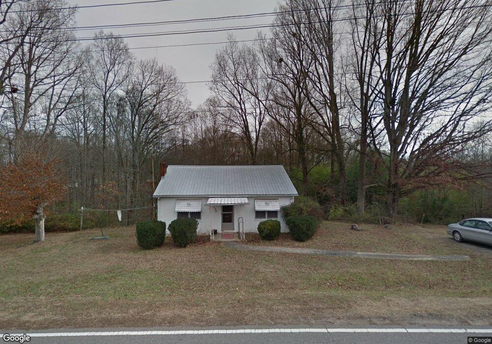
879 Perth Rd Troutman, NC 28166
Estimated Value: $144,727 - $288,000
1
Bed
1
Bath
1,054
Sq Ft
$223/Sq Ft
Est. Value
About This Home
This home is located at 879 Perth Rd, Troutman, NC 28166 and is currently estimated at $235,432, approximately $223 per square foot. 879 Perth Rd is a home located in Iredell County with nearby schools including Troutman Elementary School, Troutman Middle School, and South Iredell High School.
Ownership History
Date
Name
Owned For
Owner Type
Purchase Details
Closed on
Jan 5, 2015
Sold by
Henderson Kitty Morrow
Bought by
Henderson Max Lee
Current Estimated Value
Purchase Details
Closed on
Mar 12, 2010
Sold by
Morrow Marvin Brawley and Morrow Alice G
Bought by
Henderson Kitty Morrow
Purchase Details
Closed on
Sep 1, 1996
Purchase Details
Closed on
May 1, 1988
Purchase Details
Closed on
Oct 1, 1987
Purchase Details
Closed on
Jun 1, 1966
Create a Home Valuation Report for This Property
The Home Valuation Report is an in-depth analysis detailing your home's value as well as a comparison with similar homes in the area
Home Values in the Area
Average Home Value in this Area
Purchase History
| Date | Buyer | Sale Price | Title Company |
|---|---|---|---|
| Henderson Max Lee | -- | None Available | |
| Henderson Kitty Morrow | -- | Chicago Title Insurance Co | |
| -- | -- | -- | |
| -- | -- | -- | |
| -- | $24,000 | -- | |
| -- | -- | -- |
Source: Public Records
Tax History
| Year | Tax Paid | Tax Assessment Tax Assessment Total Assessment is a certain percentage of the fair market value that is determined by local assessors to be the total taxable value of land and additions on the property. | Land | Improvement |
|---|---|---|---|---|
| 2025 | $632 | $95,350 | $38,250 | $57,100 |
| 2024 | $632 | $95,350 | $38,250 | $57,100 |
| 2023 | $632 | $93,750 | $38,250 | $55,500 |
| 2022 | $444 | $60,230 | $30,800 | $29,430 |
| 2021 | $434 | $60,230 | $30,800 | $29,430 |
| 2020 | $434 | $60,230 | $30,800 | $29,430 |
| 2019 | $419 | $60,230 | $30,800 | $29,430 |
| 2018 | $379 | $54,770 | $27,500 | $27,270 |
| 2017 | $379 | $54,770 | $27,500 | $27,270 |
| 2016 | $379 | $54,770 | $27,500 | $27,270 |
| 2015 | $379 | $54,770 | $27,500 | $27,270 |
| 2014 | $370 | $57,880 | $27,500 | $30,380 |
Source: Public Records
Map
Nearby Homes
- 270 Spicewood Cir
- 126 Meadow Glen Dr
- 133 Crestview Ln Unit 15
- 125 Crestview Ln Unit 14
- 122 Valley Glen Dr
- 115 Park Vista Dr
- 170 Meadow Glen Dr
- 161 Fernview Trail Unit 9
- 229 Shenandoah Loop
- 137 Falls Cove Dr
- 140 Meadowfall Ln
- 164 N Hill Ln
- 175 Falls Cove Dr
- 141 Winding Creek Dr
- 177 Falls Cove Dr
- 159 Calvin Creek Dr
- 712 Georgie St
- 141 Way Cross Ln
- 156 Ashmore Cir
- 115 Outrigger Ln
- 869 Perth Rd
- 2 State Park Rd
- 889 Perth Rd
- 3 State Park Rd
- 895 Perth Rd
- 104 Spicewood Cir
- 275 Spicewood Cir
- 105 Spicewood Cir
- 105 Spicewood Cir
- 282 Spicewood Cir
- 294 Spicewood Cir
- 858 Partridge Dr
- 6/7 Spicewood Cir
- 257 Spicewood Cir
- 269 Spicewood Cir
- 276 Spicewood Cir
- 123 Spicewood Cir
- 104 Nutmeg Ln
- 915 Perth Rd
- 1211 Chaska Loop
Your Personal Tour Guide
Ask me questions while you tour the home.