Estimated Value: $432,000 - $1,148,000
3
Beds
3
Baths
2,447
Sq Ft
$354/Sq Ft
Est. Value
About This Home
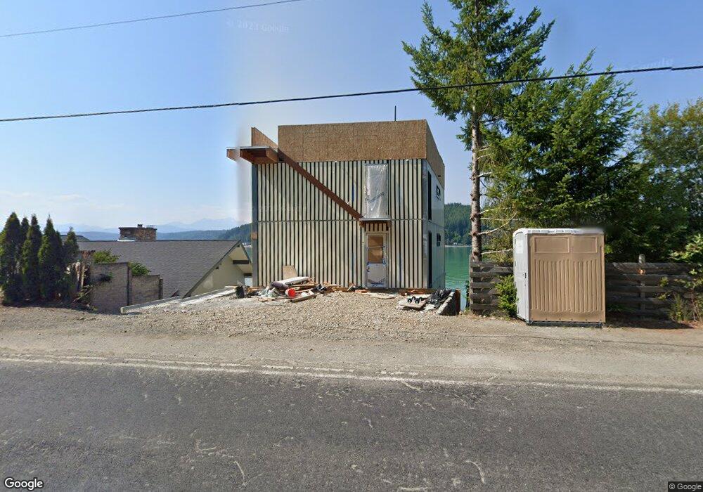
This home is located at 8791 E State Route 106, Union, WA 98592 and is currently estimated at $867,335, approximately $354 per square foot. 8791 E State Route 106 is a home with nearby schools including Hood Canal Elementary/Junior High School.
Ownership History
Date
Name
Owned For
Owner Type
Purchase Details
Closed on
Aug 24, 2020
Sold by
Bayley Joan V
Bought by
Bayley Philip N and Frihet Trust
Current Estimated Value
Purchase Details
Closed on
Dec 13, 2019
Sold by
Bayley Family Hood Canal Llc
Bought by
Bayley Joan V
Purchase Details
Closed on
Feb 1, 2013
Sold by
Bayley Joan V
Bought by
Bayley Family Hood Canal Llc
Purchase Details
Closed on
Oct 23, 2012
Sold by
1995 Bayley Family Lp
Bought by
Bayley Joan
Purchase Details
Closed on
Sep 30, 2011
Sold by
Hudson Darrin L and Hudson Carolyn Ann
Bought by
1995 Vayley Falimy Lp
Create a Home Valuation Report for This Property
The Home Valuation Report is an in-depth analysis detailing your home's value as well as a comparison with similar homes in the area
Home Values in the Area
Average Home Value in this Area
Purchase History
| Date | Buyer | Sale Price | Title Company |
|---|---|---|---|
| Bayley Philip N | -- | None Available | |
| Bayley Joan V | -- | None Available | |
| Bayley Family Hood Canal Llc | -- | -- | |
| Bayley Family Hood Canal Llc | -- | -- | |
| Bayley Joan | -- | None Available | |
| 1995 Vayley Falimy Lp | -- | Masaon County Title Ins Co |
Source: Public Records
Tax History Compared to Growth
Tax History
| Year | Tax Paid | Tax Assessment Tax Assessment Total Assessment is a certain percentage of the fair market value that is determined by local assessors to be the total taxable value of land and additions on the property. | Land | Improvement |
|---|---|---|---|---|
| 2025 | $7,304 | $1,040,765 | $214,160 | $826,605 |
| 2023 | $7,380 | $793,780 | $382,430 | $411,350 |
| 2022 | $6,101 | $666,360 | $381,710 | $284,650 |
| 2021 | $6,752 | $666,360 | $381,710 | $284,650 |
| 2020 | $6,302 | $658,545 | $387,065 | $271,480 |
| 2018 | $5,658 | $538,255 | $283,985 | $254,270 |
| 2017 | $4,798 | $538,265 | $283,995 | $254,270 |
| 2016 | $4,777 | $478,560 | $257,455 | $221,105 |
| 2015 | $4,818 | $488,650 | $265,420 | $223,230 |
| 2014 | -- | $486,525 | $265,420 | $221,105 |
| 2013 | -- | $586,105 | $365,000 | $221,105 |
Source: Public Records
Map
Nearby Homes
- 0 E Windstar Rd Unit NWM2436680
- 40 E Susan Ct
- 80 NE Brook Place
- 50 E Blackberry Ln
- 0 E Blackberry Ln
- 230 E Blackberry Ln
- 11 E Flaggwood Ln
- 161 E Blackberry Ln
- 361 Southridge Dr
- 470 E Country Club Dr E
- 0 E Mason Ave
- 21 E Eastwood Ln
- 121 E Country Club Dr E
- 280 E Laurel Park
- 971 E Manzanita Dr
- 471 E Jack Pine Ln
- 0 Sprague Ave Unit NWM2432045
- 0 Sprague Ave Unit NWM2432096
- 0 NE Hurd Rd Unit NWM2408700
- 91 E Jack Pine Ln
- 8801 E State Route 106
- 9130 E Hwy 106
- 9130 Highway 106
- 9130 E State Route 106
- 8821 E State Route 106
- 8820 Washington 106
- 8831 E State Route 106
- 8851 E State Route 106
- 8850 E State Route 106
- 8910 E State Route 106
- 8870 E State Route 106
- 8931 E State Route 106
- 8960 E State Route 106
- 8980 E State Route 106
- 9000 E State Route 106
- 9021 E State Route 106
- 9000 Washington 106
- 8534 E State Route 106
- 9030 E State Route 106
- 0 E State Route 106 Unit 1221639