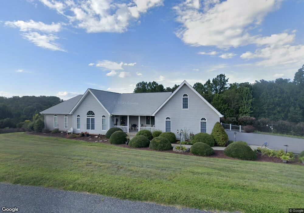
88 Foster Estate Dr Asheville, NC 28806
West Asheville NeighborhoodEstimated Value: $861,000 - $1,205,000
3
Beds
3
Baths
3,036
Sq Ft
$327/Sq Ft
Est. Value
About This Home
This home is located at 88 Foster Estate Dr, Asheville, NC 28806 and is currently estimated at $991,740, approximately $326 per square foot. 88 Foster Estate Dr is a home located in Buncombe County with nearby schools including Clyde A. Erwin High School, West Buncombe Elementary School, and Clyde A. Erwin Middle School.
Ownership History
Date
Name
Owned For
Owner Type
Purchase Details
Closed on
Nov 9, 2022
Sold by
Silvers Joe
Bought by
Joe Silvers Revocable Trust
Current Estimated Value
Purchase Details
Closed on
Jun 8, 2000
Sold by
Kline Jack L and Kline Kirsty A
Bought by
Silvers Joe and Silvers Patricia
Purchase Details
Closed on
Jul 30, 1999
Sold by
Ballard Rex E and Ballard Evelyn M
Bought by
Kline Jack L and Kline Kirsty A
Create a Home Valuation Report for This Property
The Home Valuation Report is an in-depth analysis detailing your home's value as well as a comparison with similar homes in the area
Home Values in the Area
Average Home Value in this Area
Purchase History
| Date | Buyer | Sale Price | Title Company |
|---|---|---|---|
| Joe Silvers Revocable Trust | -- | -- | |
| Silvers Joe | $55,000 | -- | |
| Kline Jack L | $44,500 | -- |
Source: Public Records
Tax History Compared to Growth
Tax History
| Year | Tax Paid | Tax Assessment Tax Assessment Total Assessment is a certain percentage of the fair market value that is determined by local assessors to be the total taxable value of land and additions on the property. | Land | Improvement |
|---|---|---|---|---|
| 2025 | -- | $613,600 | $141,300 | $472,300 |
| 2024 | -- | $613,600 | $141,300 | $472,300 |
| 2023 | $3,884 | $613,600 | $141,300 | $472,300 |
| 2022 | $3,823 | $613,600 | $0 | $0 |
| 2021 | $3,823 | $613,600 | $0 | $0 |
| 2020 | $3,584 | $535,700 | $0 | $0 |
| 2019 | $3,584 | $535,700 | $0 | $0 |
| 2018 | $3,530 | $535,700 | $0 | $0 |
| 2017 | $3,530 | $418,200 | $0 | $0 |
| 2016 | $3,028 | $418,200 | $0 | $0 |
| 2015 | $3,028 | $418,200 | $0 | $0 |
| 2014 | $2,944 | $418,200 | $0 | $0 |
Source: Public Records
Map
Nearby Homes
- 254 Mount Carmel Rd
- 117 Scott Meadows Dr
- 110 Scott Meadows Dr
- 78 Scott Meadows Dr
- 71 Scott Meadows Dr
- 129 Scott Meadows Dr
- 79 Scott Meadows Dr
- 59 Knollview Dr
- 50 Tipperary Dr
- 116 Dix Creek Chapel Rd
- 23 Westmont Dr
- 3 Audrey Ln
- 1024 Bear Creek Rd
- 14 H G Buckner Meadows
- 14 H G Buckner Meadows Rd
- 109 Meadow Run
- 75 Panorama Dr
- 107 Mears Ridge Dr
- 18 Bianca Way
- 88 Lees Creek Rd
- 12 Brookside Dr
- 7 Brookside Dr Unit 13
- 95 Foster Estate Dr
- 114 Foster Estate Dr
- 11 Remington Dr
- 11 Brookside Dr
- 69 Foster Estate Dr
- 70 Foster Estate Dr
- 122 Foster Estate Dr
- 16 Brookside Dr
- 125 Foster Estate Dr
- 28 Foster Estate Dr
- 17 Remington Dr
- 15 Brookside Dr
- 22 Foster Estate Dr
- 29 Sunset Dr
- 18 Foster Estate Dr
- 19 Brookside Dr
- 133 Foster Estate Dr
- 132 Foster Estate Dr