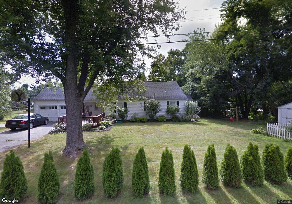
88 Main St Wilbraham, MA 01095
Estimated Value: $386,000 - $478,000
3
Beds
2
Baths
1,894
Sq Ft
$221/Sq Ft
Est. Value
About This Home
This home is located at 88 Main St, Wilbraham, MA 01095 and is currently estimated at $418,410, approximately $220 per square foot. 88 Main St is a home located in Hampden County with nearby schools including Minnechaug Regional High School and Wilbraham & Monson Academy.
Ownership History
Date
Name
Owned For
Owner Type
Purchase Details
Closed on
Feb 29, 2008
Sold by
Matin Arif and Matin Naseem
Bought by
Fogarty Patrick J
Current Estimated Value
Home Financials for this Owner
Home Financials are based on the most recent Mortgage that was taken out on this home.
Original Mortgage
$204,250
Interest Rate
5.8%
Mortgage Type
Purchase Money Mortgage
Purchase Details
Closed on
Feb 18, 1994
Sold by
Baslik Clinton E and Baslik Louise L
Bought by
Matin Arif and Matin Naseem
Purchase Details
Closed on
Jul 31, 1987
Sold by
Blizard Leonard W
Bought by
Baslik Clinton E
Create a Home Valuation Report for This Property
The Home Valuation Report is an in-depth analysis detailing your home's value as well as a comparison with similar homes in the area
Home Values in the Area
Average Home Value in this Area
Purchase History
| Date | Buyer | Sale Price | Title Company |
|---|---|---|---|
| Fogarty Patrick J | $215,000 | -- | |
| Matin Arif | $145,000 | -- | |
| Baslik Clinton E | $138,900 | -- |
Source: Public Records
Mortgage History
| Date | Status | Borrower | Loan Amount |
|---|---|---|---|
| Open | Baslik Clinton E | $207,000 | |
| Closed | Fogarty Patrick J | $204,250 | |
| Previous Owner | Baslik Clinton E | $40,000 |
Source: Public Records
Tax History
| Year | Tax Paid | Tax Assessment Tax Assessment Total Assessment is a certain percentage of the fair market value that is determined by local assessors to be the total taxable value of land and additions on the property. | Land | Improvement |
|---|---|---|---|---|
| 2025 | $5,373 | $300,500 | $79,700 | $220,800 |
| 2024 | $4,830 | $261,100 | $79,700 | $181,400 |
| 2023 | $5,088 | $257,000 | $79,700 | $177,300 |
| 2022 | $5,088 | $248,300 | $79,700 | $168,600 |
| 2021 | $5,028 | $219,000 | $85,500 | $133,500 |
| 2020 | $4,901 | $219,000 | $85,500 | $133,500 |
| 2019 | $4,774 | $219,000 | $85,500 | $133,500 |
| 2018 | $4,616 | $203,900 | $85,500 | $118,400 |
| 2017 | $4,486 | $203,900 | $85,500 | $118,400 |
| 2016 | $4,333 | $200,600 | $95,000 | $105,600 |
| 2015 | $4,189 | $200,600 | $95,000 | $105,600 |
Source: Public Records
Map
Nearby Homes
- 1 Aspen Dr
- 35 Lake Dr
- 104 High Pine Cir
- 16 Maple St
- 4 Hillcrest Dr
- 36 Maple St
- 46 Washington Rd
- 20 Old Orchard Rd
- 474-480 Mountain Rd
- 474 Mountain Rd
- 3076 Boston Rd
- 8 Patriot Ridge Ln
- 80 Elizabeth Dr
- 3 Mohawk St
- 38 King Dr
- 37 Balsam Hill Rd
- 6 Teak Terrace Unit 24
- 44 Balsam Hill Rd
- 6 Hilltop Park
- 103 Sandalwood Dr Unit site 00
Your Personal Tour Guide
Ask me questions while you tour the home.