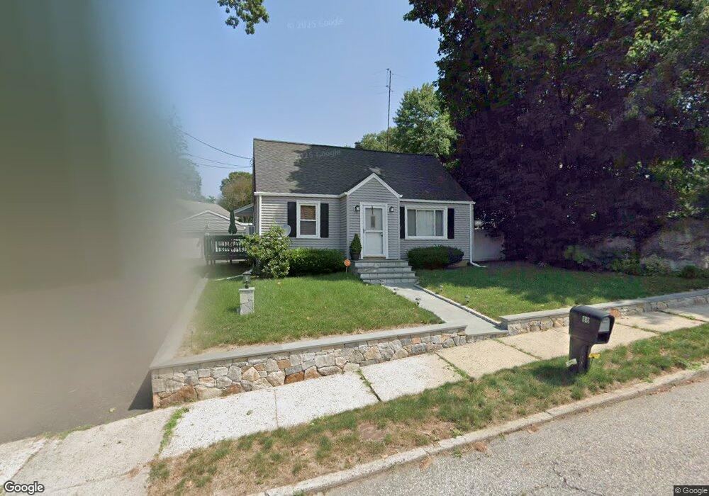
88 Memory Ln Bridgeport, CT 06606
Reservoir-Whiskey Hill NeighborhoodEstimated Value: $427,000 - $470,000
3
Beds
2
Baths
1,267
Sq Ft
$347/Sq Ft
Est. Value
About This Home
This home is located at 88 Memory Ln, Bridgeport, CT 06606 and is currently estimated at $440,141, approximately $347 per square foot. 88 Memory Ln is a home located in Fairfield County with nearby schools including Wilbur L. Cross Elementary School, Central High School, and Northeastern Adventist Academy - Fairfield County.
Ownership History
Date
Name
Owned For
Owner Type
Purchase Details
Closed on
Dec 21, 1993
Sold by
Ford Consumer Finc Co
Bought by
Edwards Sean
Current Estimated Value
Create a Home Valuation Report for This Property
The Home Valuation Report is an in-depth analysis detailing your home's value as well as a comparison with similar homes in the area
Home Values in the Area
Average Home Value in this Area
Purchase History
| Date | Buyer | Sale Price | Title Company |
|---|---|---|---|
| Edwards Sean | $80,000 | -- | |
| Edwards Sean | $80,000 | -- |
Source: Public Records
Mortgage History
| Date | Status | Borrower | Loan Amount |
|---|---|---|---|
| Open | Edwards Sean | $155,300 | |
| Closed | Edwards Sean | $191,250 | |
| Closed | Edwards Sean | $28,000 |
Source: Public Records
Tax History
| Year | Tax Paid | Tax Assessment Tax Assessment Total Assessment is a certain percentage of the fair market value that is determined by local assessors to be the total taxable value of land and additions on the property. | Land | Improvement |
|---|---|---|---|---|
| 2025 | $7,319 | $168,450 | $67,070 | $101,380 |
| 2024 | $7,319 | $168,450 | $67,070 | $101,380 |
| 2023 | $7,319 | $168,450 | $67,070 | $101,380 |
| 2022 | $7,319 | $168,450 | $67,070 | $101,380 |
| 2021 | $7,319 | $168,450 | $67,070 | $101,380 |
| 2020 | $6,931 | $128,370 | $46,730 | $81,640 |
| 2019 | $6,931 | $128,370 | $46,730 | $81,640 |
| 2018 | $6,979 | $128,370 | $46,730 | $81,640 |
| 2017 | $6,979 | $128,370 | $46,730 | $81,640 |
| 2016 | $6,979 | $128,370 | $46,730 | $81,640 |
| 2015 | $6,841 | $162,120 | $59,520 | $102,600 |
| 2014 | $6,841 | $162,120 | $59,520 | $102,600 |
Source: Public Records
Map
Nearby Homes
- 1403 Old Town Rd Unit 1403
- 74 Village Ln
- 563 Lakeside Dr
- 1376 Chopsey Hill Rd
- 1320 Chopsey Hill Rd
- 46 Oakleaf St
- 11 Linda Dr
- 364 Griffin Ave
- 26 Karen Ct Unit A
- 165 Yaremich Dr
- 82 Yaremich Dr
- 45 Frenchtown Rd
- 65 Clearview Dr
- 291 Frenchtown Rd
- 274 Platt St
- 65 Bonnie View Dr
- 181 Cityview Ave
- 365 Platt St
- 410 Alba Ave
- 85 Platt St
- 102 Memory Ln
- 72 Memory Ln
- 69 Memory Ln
- 58 Memory Ln
- 97 Memory Ln
- 85 Memory Ln
- 1978 Chopsey Hill Rd
- 1982 Chopsey Hill Rd
- 1980 Chopsey Hill Rd
- 42 Memory Ln
- 1990 Chopsey Hill Rd
- 1941 Chopsey Hill Rd
- 55 Memory Ln
- 1925 Chopsey Hill Rd
- 41 Memory Ln
- 1953 Chopsey Hill Rd
- 290 Red Oak Ln
- 1913 Chopsey Hill Rd
- 347 Red Oak Ln
- 180 Red Oak Ln
Your Personal Tour Guide
Ask me questions while you tour the home.