Estimated Value: $398,000 - $450,000
5
Beds
3
Baths
2,128
Sq Ft
$199/Sq Ft
Est. Value
About This Home
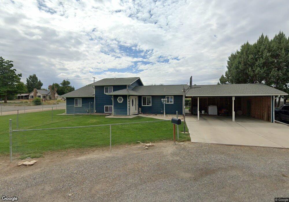
This home is located at 880 Sharpe Cir, Delta, CO 81416 and is currently estimated at $423,463, approximately $198 per square foot. 880 Sharpe Cir is a home located in Delta County with nearby schools including Garnet Mesa Elementary School, Lincoln Elementary School, and Delta Middle School.
Ownership History
Date
Name
Owned For
Owner Type
Purchase Details
Closed on
Oct 23, 2013
Sold by
Fannie Mae
Bought by
Morgan Michael E and Morgan Betty L
Current Estimated Value
Home Financials for this Owner
Home Financials are based on the most recent Mortgage that was taken out on this home.
Original Mortgage
$71,400
Outstanding Balance
$53,776
Interest Rate
4.56%
Mortgage Type
New Conventional
Estimated Equity
$369,687
Purchase Details
Closed on
Feb 15, 2013
Sold by
Scott Beulah M
Bought by
Onewest Bank Fsb
Purchase Details
Closed on
Dec 18, 2012
Sold by
Onewest Bank Fsb
Bought by
Fannie Mae and Federal National Mortgage Association
Purchase Details
Closed on
Dec 18, 2006
Sold by
Vincent Larry D
Bought by
Scott Beulah M
Home Financials for this Owner
Home Financials are based on the most recent Mortgage that was taken out on this home.
Original Mortgage
$50,800
Interest Rate
6.27%
Mortgage Type
Stand Alone Second
Create a Home Valuation Report for This Property
The Home Valuation Report is an in-depth analysis detailing your home's value as well as a comparison with similar homes in the area
Home Values in the Area
Average Home Value in this Area
Purchase History
| Date | Buyer | Sale Price | Title Company |
|---|---|---|---|
| Morgan Michael E | $139,900 | None Available | |
| Onewest Bank Fsb | -- | None Available | |
| Fannie Mae | -- | None Available | |
| Scott Beulah M | $254,000 | Security Title |
Source: Public Records
Mortgage History
| Date | Status | Borrower | Loan Amount |
|---|---|---|---|
| Open | Morgan Michael E | $71,400 | |
| Previous Owner | Scott Beulah M | $50,800 | |
| Previous Owner | Scott Beulah M | $203,200 |
Source: Public Records
Tax History Compared to Growth
Tax History
| Year | Tax Paid | Tax Assessment Tax Assessment Total Assessment is a certain percentage of the fair market value that is determined by local assessors to be the total taxable value of land and additions on the property. | Land | Improvement |
|---|---|---|---|---|
| 2024 | $1,528 | $23,089 | $2,889 | $20,200 |
| 2023 | $1,528 | $23,089 | $2,889 | $20,200 |
| 2022 | $1,311 | $20,313 | $3,128 | $17,185 |
| 2021 | $1,324 | $20,898 | $3,218 | $17,680 |
| 2020 | $1,217 | $18,943 | $2,860 | $16,083 |
| 2019 | $1,205 | $18,943 | $2,860 | $16,083 |
| 2018 | $1,015 | $15,379 | $2,016 | $13,363 |
| 2017 | $986 | $15,379 | $2,016 | $13,363 |
| 2016 | $765 | $13,075 | $2,229 | $10,846 |
| 2014 | -- | $13,536 | $2,428 | $11,108 |
Source: Public Records
Map
Nearby Homes
- 890 Sharpe Cir
- 870 Sharpe Cir
- 1571 Cherry Ln
- 0 Cherry Ln
- 860 Sharpe Cir
- 0 Sharpe Cir Unit 731182
- 0 Sharpe Cir Unit 610080
- 0 Sharpe Cir Unit 677477
- 0 Sharpe Cir Unit 677896
- 0 Sharpe Cir Unit 683969
- 0 Sharpe Cir Unit 698113
- 0 Sharpe Cir Unit 711827
- 0 Sharpe Cir Unit 716865
- 0 Jensen Dr
- 0 Brown St
- 800 Brown St
- 1570 Cherry Ln
- 895 Jensen Dr
- 875 Jensen Dr
- 891 Huff St