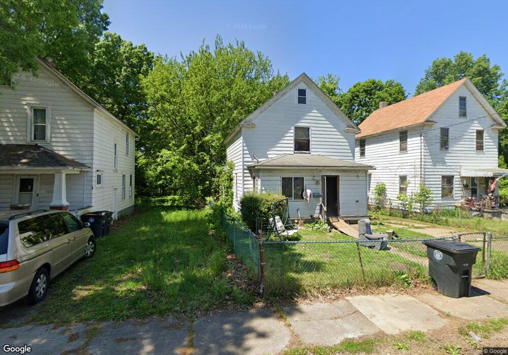
880 Sherman St Akron, OH 44311
South Akron NeighborhoodEstimated Value: $50,000 - $80,966
2
Beds
2
Baths
1,244
Sq Ft
$50/Sq Ft
Est. Value
About This Home
This home is located at 880 Sherman St, Akron, OH 44311 and is currently estimated at $62,742, approximately $50 per square foot. 880 Sherman St is a home located in Summit County with nearby schools including McEbright Elementary School, Kenmore Garfield Community Learning Center, and Main Preparatory Academy.
Ownership History
Date
Name
Owned For
Owner Type
Purchase Details
Closed on
Aug 3, 1998
Sold by
Kufener Daniel K
Bought by
Hayes Paul D
Current Estimated Value
Purchase Details
Closed on
Jul 11, 1995
Sold by
Nutter Clay L
Bought by
Rufener Daniel R and Rufener Meredith L
Home Financials for this Owner
Home Financials are based on the most recent Mortgage that was taken out on this home.
Original Mortgage
$20,200
Interest Rate
7.9%
Mortgage Type
FHA
Create a Home Valuation Report for This Property
The Home Valuation Report is an in-depth analysis detailing your home's value as well as a comparison with similar homes in the area
Home Values in the Area
Average Home Value in this Area
Purchase History
| Date | Buyer | Sale Price | Title Company |
|---|---|---|---|
| Hayes Paul D | $20,000 | -- | |
| Rufener Daniel R | $25,000 | -- |
Source: Public Records
Mortgage History
| Date | Status | Borrower | Loan Amount |
|---|---|---|---|
| Previous Owner | Rufener Daniel R | $20,200 |
Source: Public Records
Tax History Compared to Growth
Tax History
| Year | Tax Paid | Tax Assessment Tax Assessment Total Assessment is a certain percentage of the fair market value that is determined by local assessors to be the total taxable value of land and additions on the property. | Land | Improvement |
|---|---|---|---|---|
| 2025 | $907 | $16,024 | $4,666 | $11,358 |
| 2024 | $907 | $16,024 | $4,666 | $11,358 |
| 2023 | $907 | $16,024 | $4,666 | $11,358 |
| 2022 | $694 | $9,426 | $2,744 | $6,682 |
| 2021 | $695 | $9,426 | $2,744 | $6,682 |
| 2020 | $685 | $9,420 | $2,740 | $6,680 |
| 2019 | $911 | $11,670 | $5,120 | $6,550 |
| 2018 | $899 | $11,670 | $5,120 | $6,550 |
| 2017 | $923 | $11,670 | $5,120 | $6,550 |
| 2016 | $924 | $11,810 | $5,120 | $6,690 |
| 2015 | $923 | $11,810 | $5,120 | $6,690 |
| 2014 | $916 | $11,810 | $5,120 | $6,690 |
| 2013 | $941 | $12,410 | $5,120 | $7,290 |
Source: Public Records
Map
Nearby Homes
- 841 Grant St
- 833 Sherman St
- 848 Kling St
- 841 Kling St
- 1148 Marcy St
- 1044 Grant St
- 917 Clay St
- 687 Allyn St
- 386 E Voris St
- 542 Baird St
- 678 Sumner St Unit 682
- 668 Sherman St
- 546 Baird St
- 448 E Voris St
- 656 Kling St Unit 2
- 685 Brown St
- 253,257,261,263 E Thornton St
- 281 E Thornton St
- 559 Morgan Ave
- 628, 634 & 636 Sumner St Unit 6 units
- 884 Sherman St
- 878 Sherman St
- 892 Sherman St
- 876 Sherman St
- 320 E Crosier St
- 874 Sherman St
- 310 E Crosier St
- 896 Sherman St
- 885 1/2 Grant St
- 304 E Crosier St
- 875 Sherman St
- 889 Sherman St
- 881 Grant St
- 881 Grant St
- 871 Grant St
- 900 Sherman St
- 881 Sherman St
- 879 Sherman St
- 885 Sherman St
- 891 Sherman St