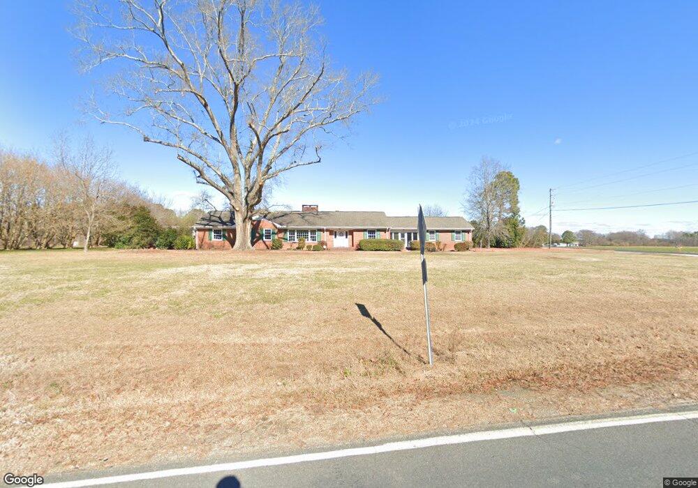
880 Wire Rd Bunnlevel, NC 28323
Estimated Value: $280,000 - $452,000
3
Beds
2
Baths
2,930
Sq Ft
$125/Sq Ft
Est. Value
About This Home
This home is located at 880 Wire Rd, Bunnlevel, NC 28323 and is currently estimated at $365,366, approximately $124 per square foot. 880 Wire Rd is a home located in Harnett County with nearby schools including Lillington-Shawtown Elementary School, Harnett Central Middle School, and Harnett Central High School.
Ownership History
Date
Name
Owned For
Owner Type
Purchase Details
Closed on
Mar 16, 2016
Sold by
Byrd William Bryan
Bought by
Linville Joseph Tyler and Linville Elizabeth Stephens
Current Estimated Value
Home Financials for this Owner
Home Financials are based on the most recent Mortgage that was taken out on this home.
Original Mortgage
$187,500
Outstanding Balance
$148,553
Interest Rate
3.68%
Estimated Equity
$216,813
Create a Home Valuation Report for This Property
The Home Valuation Report is an in-depth analysis detailing your home's value as well as a comparison with similar homes in the area
Home Values in the Area
Average Home Value in this Area
Purchase History
| Date | Buyer | Sale Price | Title Company |
|---|---|---|---|
| Linville Joseph Tyler | $187,500 | -- |
Source: Public Records
Mortgage History
| Date | Status | Borrower | Loan Amount |
|---|---|---|---|
| Open | Linville Joseph Tyler | $187,500 |
Source: Public Records
Tax History
| Year | Tax Paid | Tax Assessment Tax Assessment Total Assessment is a certain percentage of the fair market value that is determined by local assessors to be the total taxable value of land and additions on the property. | Land | Improvement |
|---|---|---|---|---|
| 2025 | $1,887 | $256,992 | $0 | $0 |
| 2024 | $1,861 | $256,992 | $0 | $0 |
| 2023 | $1,861 | $256,992 | $0 | $0 |
| 2022 | $1,679 | $256,992 | $0 | $0 |
| 2021 | $1,679 | $187,530 | $0 | $0 |
| 2020 | $1,679 | $187,530 | $0 | $0 |
| 2019 | $1,664 | $187,530 | $0 | $0 |
| 2018 | $1,664 | $187,530 | $0 | $0 |
| 2017 | $1,627 | $187,530 | $0 | $0 |
| 2016 | $1,231 | $139,930 | $0 | $0 |
| 2015 | $1,220 | $138,570 | $0 | $0 |
| 2014 | $1,220 | $138,570 | $0 | $0 |
Source: Public Records
Map
Nearby Homes
- 444 Sanderfer Rd
- 0 Sanderfer Rd Unit 10126922
- 7111 U S 401
- 3792 McNeill Hobbs Rd
- 6200 U S 401
- 2044 Wire Rd
- 0 Wire Rd
- 2727 Wire Rd
- 1271 Nutgrass Rd
- 2470 Wire Rd
- 2915 McLean Chapel Church Rd
- 1925 Bunnlevel Erwin Rd
- 1655 Bunnlevel Erwin Rd
- 1333 Bunnlevel Erwin Rd
- 3905 McLean Chapel Church Rd
- 0 Walker Rd Unit 752184
- 176 Josey Williams Rd
- 104 Josey Williams Rd
- 687 Brock Rd
- 155 Nectar Ln
- 1060 McLean Chapel Church Rd
- 734 Wire Rd
- 1220 McLean Chapel Church Rd
- 655 Wire Rd
- 621 Wire Rd
- 1286 McLean Chapel Church Rd
- 1334 McLean Chapel Church Rd
- 1311 McLean Chapel Church Rd
- 1410 McLean Chapel Church Rd
- 691 McLean Chapel Church Rd
- 1374 McLean Chapel Church Rd
- 1365 McLean Chapel Church Rd
- 1390 McLean Chapel Church Rd
- 499 Wire Rd
- 486 Wire Rd
- 1428 McLean Chapel Church Rd
- 1448 McLean Chapel Church Rd
- 1464 McLean Chapel Church Rd
- 435 Wire Rd
- 1482 McLean Chapel Church Rd
Your Personal Tour Guide
Ask me questions while you tour the home.