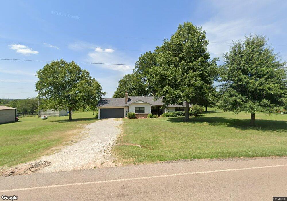
880389 S 3420 Rd Chandler, OK 74834
Estimated Value: $133,114 - $245,000
3
Beds
1
Bath
1,293
Sq Ft
$155/Sq Ft
Est. Value
About This Home
This home is located at 880389 S 3420 Rd, Chandler, OK 74834 and is currently estimated at $200,779, approximately $155 per square foot. 880389 S 3420 Rd is a home located in Lincoln County with nearby schools including East Side Elementary School, Park Road Elementary School, and Chandler Junior High School.
Ownership History
Date
Name
Owned For
Owner Type
Purchase Details
Closed on
Nov 20, 2003
Sold by
Alsip Kathryn D Fka Boon
Bought by
Alsip David Andrew and Alsip Kathr
Current Estimated Value
Purchase Details
Closed on
Aug 31, 1998
Sold by
Alsip Kathryn D Boonthee
Bought by
Alsip David A and Alsip Kathryn D
Purchase Details
Closed on
Jan 18, 1995
Sold by
Miller Wilma
Bought by
Boontheekul Kathryn D
Create a Home Valuation Report for This Property
The Home Valuation Report is an in-depth analysis detailing your home's value as well as a comparison with similar homes in the area
Home Values in the Area
Average Home Value in this Area
Purchase History
| Date | Buyer | Sale Price | Title Company |
|---|---|---|---|
| Alsip David Andrew | -- | -- | |
| Alsip David A | -- | -- | |
| Boontheekul Kathryn D | $52,000 | -- |
Source: Public Records
Tax History Compared to Growth
Tax History
| Year | Tax Paid | Tax Assessment Tax Assessment Total Assessment is a certain percentage of the fair market value that is determined by local assessors to be the total taxable value of land and additions on the property. | Land | Improvement |
|---|---|---|---|---|
| 2024 | $332 | $3,538 | $1,033 | $2,505 |
| 2023 | $332 | $10,038 | $1,033 | $9,005 |
| 2022 | $297 | $4,406 | $444 | $3,962 |
| 2021 | $293 | $4,277 | $472 | $3,805 |
| 2020 | $291 | $4,153 | $516 | $3,637 |
| 2019 | $284 | $4,032 | $496 | $3,536 |
| 2018 | $268 | $3,915 | $491 | $3,424 |
| 2017 | $259 | $3,801 | $506 | $3,295 |
| 2016 | $244 | $3,690 | $435 | $3,255 |
| 2015 | $237 | $3,582 | $428 | $3,154 |
| 2014 | $227 | $3,479 | $342 | $3,137 |
Source: Public Records
Map
Nearby Homes
- 870737 S Tee Ave
- 880014 S Carey Ln
- 880035 S Carey Ln
- 0000 E 890 Rd
- 0 Hope Cir
- 0 S 3430 Rd Unit 1173245
- 343248 E 890 Rd
- 116 Sunny Place
- 0 S 3400 Rd
- 343787 E 870 Rd
- 343679 Round Rock Dr
- Williamette Plan at Round Rock
- Yellowstone Plan at Round Rock
- White River Plan at Round Rock
- Talladega Plan at Round Rock
- Wallowa Plan at Round Rock
- Umatilla Plan at Round Rock
- Sierra Plan at Round Rock
- Rio Grande Plan at Round Rock
- Prescott Plan at Round Rock
- 880417 S 3420 Rd
- 880311 S 3420 Rd
- 880487 S 3420 Rd
- 880295 S 3420 Rd
- 880648 S 3420 Rd
- 880119 S 3420 Rd
- 880600 S 3420 Rd
- 880696 S 3420 Rd
- 930001 S 3480 Rd
- 341883 E 880 Rd
- 2750 N Lake Rd
- 341936 E 880 Rd
- 341864 E 880 Rd
- 341880 E 880 Rd
- 341874 E 880 Rd
- 341675 E 880 Rd
- 870915 S 3420 Rd
- 1204 N Post Rd
- 890025 S 3503 Rd