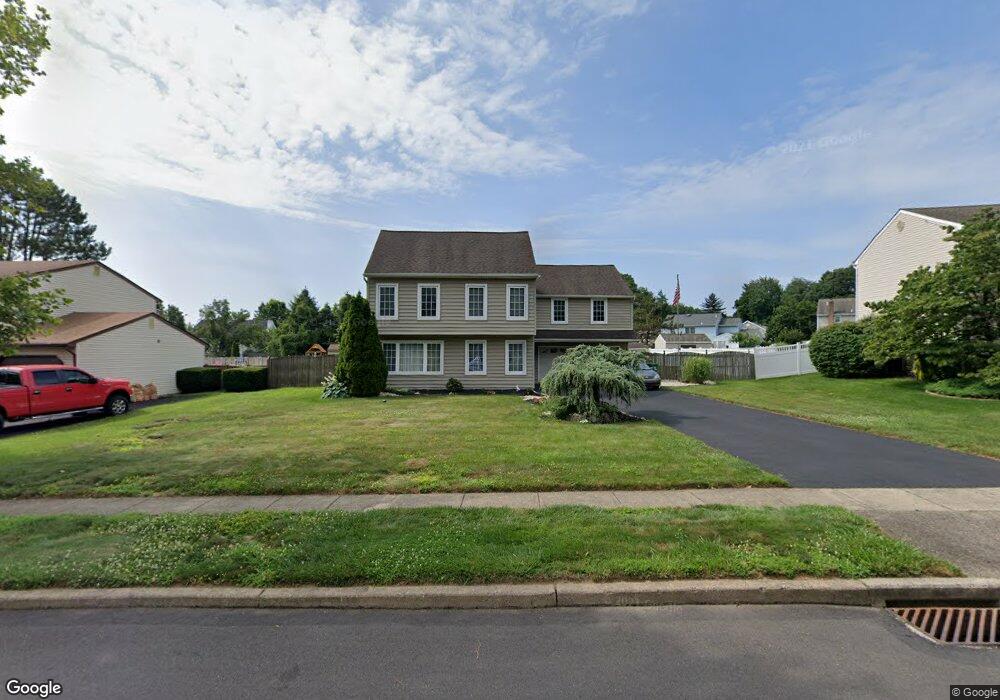
882 Jordan Dr Bensalem, PA 19020
Estimated Value: $562,000 - $639,000
4
Beds
3
Baths
2,172
Sq Ft
$278/Sq Ft
Est. Value
About This Home
This home is located at 882 Jordan Dr, Bensalem, PA 19020 and is currently estimated at $603,887, approximately $278 per square foot. 882 Jordan Dr is a home located in Bucks County with nearby schools including School Lane Charter School, St. Ephrem School, and Holy Ghost Preparatory School.
Ownership History
Date
Name
Owned For
Owner Type
Purchase Details
Closed on
May 5, 2017
Sold by
Green Richard C and Green Donna M
Bought by
Green Richard C
Current Estimated Value
Purchase Details
Closed on
Aug 21, 1998
Sold by
Arone John A and Arone Teriann M
Bought by
Green Richard C and Green Donna M
Home Financials for this Owner
Home Financials are based on the most recent Mortgage that was taken out on this home.
Original Mortgage
$90,000
Interest Rate
6.9%
Purchase Details
Closed on
Nov 4, 1992
Bought by
Arone John A and Arone Teriann M
Create a Home Valuation Report for This Property
The Home Valuation Report is an in-depth analysis detailing your home's value as well as a comparison with similar homes in the area
Home Values in the Area
Average Home Value in this Area
Purchase History
| Date | Buyer | Sale Price | Title Company |
|---|---|---|---|
| Green Richard C | -- | None Available | |
| Green Richard C | $185,000 | -- | |
| Arone John A | -- | -- |
Source: Public Records
Mortgage History
| Date | Status | Borrower | Loan Amount |
|---|---|---|---|
| Closed | Green Richard C | $90,000 |
Source: Public Records
Tax History Compared to Growth
Tax History
| Year | Tax Paid | Tax Assessment Tax Assessment Total Assessment is a certain percentage of the fair market value that is determined by local assessors to be the total taxable value of land and additions on the property. | Land | Improvement |
|---|---|---|---|---|
| 2025 | $7,562 | $34,640 | $8,960 | $25,680 |
| 2024 | $7,562 | $34,640 | $8,960 | $25,680 |
| 2023 | $7,348 | $34,640 | $8,960 | $25,680 |
| 2022 | $7,306 | $34,640 | $8,960 | $25,680 |
| 2021 | $7,306 | $34,640 | $8,960 | $25,680 |
| 2020 | $7,232 | $34,640 | $8,960 | $25,680 |
| 2019 | $7,071 | $34,640 | $8,960 | $25,680 |
| 2018 | $6,907 | $34,640 | $8,960 | $25,680 |
| 2017 | $6,864 | $34,640 | $8,960 | $25,680 |
| 2016 | $6,864 | $34,640 | $8,960 | $25,680 |
| 2015 | -- | $34,640 | $8,960 | $25,680 |
| 2014 | -- | $34,640 | $8,960 | $25,680 |
Source: Public Records
Map
Nearby Homes
- 938 Ashton Rd
- 801 Cliff Rd
- 446 N Mount Vernon Cir Unit 446
- 419 Rutgers Ct
- 389 Rutgers Ct Unit 389
- 435 N Mount Vernon Cir Unit 435
- 953 Farley Rd
- 1100 Wayland Ave
- 5102 Lighthouse Ln
- 5107 Leeward Rd
- 5110 Bay Rd
- 4744 Dunston Rd
- L:15 Dunston Rd
- 0 Newportville Rd Unit PABU487252
- 906 Stephen Ave
- 3300 Newportville Rd
- 209 Clover Ave
- 1719 Dixon Ave
- 1050 Village Dr
- 110 Neshaminy Rd