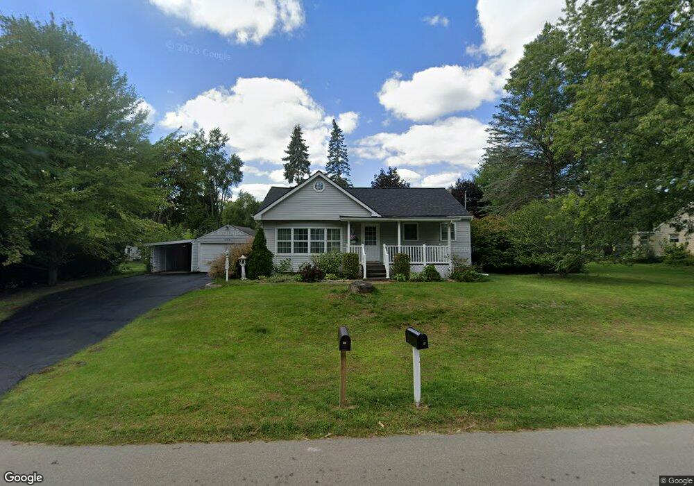
882 Longfellow Ave Jackson, MI 49202
Estimated Value: $143,425 - $181,000
Studio
--
Bath
1,260
Sq Ft
$129/Sq Ft
Est. Value
About This Home
This home is located at 882 Longfellow Ave, Jackson, MI 49202 and is currently estimated at $162,356, approximately $128 per square foot. 882 Longfellow Ave is a home located in Jackson County with nearby schools including Hunt Elementary School, Middle School at Parkside, and Jackson High School.
Ownership History
Date
Name
Owned For
Owner Type
Purchase Details
Closed on
Oct 3, 2005
Sold by
Kuntz Doris A and Kuntz David L
Bought by
Tripp Deborah Sue
Current Estimated Value
Home Financials for this Owner
Home Financials are based on the most recent Mortgage that was taken out on this home.
Original Mortgage
$126,800
Outstanding Balance
$68,382
Interest Rate
5.88%
Mortgage Type
Fannie Mae Freddie Mac
Estimated Equity
$93,974
Purchase Details
Closed on
Oct 1, 1991
Bought by
Kuntz
Create a Home Valuation Report for This Property
The Home Valuation Report is an in-depth analysis detailing your home's value as well as a comparison with similar homes in the area
Home Values in the Area
Average Home Value in this Area
Purchase History
| Date | Buyer | Sale Price | Title Company |
|---|---|---|---|
| Tripp Deborah Sue | $126,800 | At | |
| Kuntz | $48,000 | -- |
Source: Public Records
Mortgage History
| Date | Status | Borrower | Loan Amount |
|---|---|---|---|
| Open | Tripp Deborah Sue | $126,800 |
Source: Public Records
Tax History
| Year | Tax Paid | Tax Assessment Tax Assessment Total Assessment is a certain percentage of the fair market value that is determined by local assessors to be the total taxable value of land and additions on the property. | Land | Improvement |
|---|---|---|---|---|
| 2025 | $2,290 | $69,600 | $0 | $0 |
| 2024 | $14 | $76,950 | $0 | $0 |
| 2023 | $1,351 | $71,200 | $0 | $0 |
| 2022 | $2,079 | $62,800 | $0 | $0 |
| 2021 | $2,041 | $64,100 | $0 | $0 |
| 2020 | $2,015 | $62,200 | $0 | $0 |
| 2019 | $2,155 | $57,500 | $0 | $0 |
| 2018 | $1,984 | $55,900 | $0 | $0 |
| 2017 | $1,734 | $51,000 | $0 | $0 |
| 2016 | $1,002 | $50,309 | $50,309 | $0 |
| 2015 | $1,458 | $49,748 | $49,748 | $0 |
| 2014 | $1,458 | $47,928 | $0 | $0 |
| 2013 | -- | $47,928 | $47,928 | $0 |
Source: Public Records
Map
Nearby Homes
- 923 Wayne St
- 870 Bryant Ave
- 705 Varden Dr
- 1802 W Argyle St
- 2318 Lancaster Blvd
- 0 N Brown St
- 221 N Higby St
- VL Laurence Ave
- 0 VL Laurence Ave
- 534 Barrett Ave
- 718 Center St
- 835 N West Ave
- 831 N West Ave
- 1006 Wildwood Ave
- 836 Lincoln St
- 311 Hibbard Ave
- 0 Laurence Ave Unit 25062864
- 713 Webb St
- 108 N Thompson St
- 121 N Thompson St
- 896 Longfellow Ave
- 896 Longfellow Ave
- 881 Lowell Ave
- 850 Longfellow Ave
- 885 Lowell Ave
- 877 Lowell Ave
- 898 Longfellow Ave
- 898 Longfellow Ave
- 881 Longfellow Ave
- 881 Longfellow Ave Unit LONG FELLOW
- 844 Longfellow Ave
- 851 Longfellow Ave
- 889 Longfellow Ave
- 816 Longfellow Ave
- 811 Lowell Ave
- 844 Lowell Ave
- 1920 W North St
- 812 Longfellow Ave
- 880 Winifred St
- 852 Lowell Ave
Your Personal Tour Guide
Ask me questions while you tour the home.