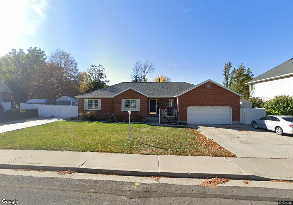
884 E 800 S Springville, UT 84663
East Hobble Creek NeighborhoodEstimated Value: $673,000 - $788,000
5
Beds
3
Baths
3,784
Sq Ft
$189/Sq Ft
Est. Value
About This Home
This home is located at 884 E 800 S, Springville, UT 84663 and is currently estimated at $714,839, approximately $188 per square foot. 884 E 800 S is a home located in Utah County with nearby schools including Brookside School, Springville High School, and Springville Junior High School.
Ownership History
Date
Name
Owned For
Owner Type
Purchase Details
Closed on
Jul 2, 2020
Sold by
Brooks Ashley A and Brooks Patricia A
Bought by
Brooks Ashley and Brooks Patricia A
Current Estimated Value
Purchase Details
Closed on
Mar 20, 2008
Sold by
Brooks Ashley A and Brooks Patricia
Bought by
Brooks Ashley A and Brooks Patricia A
Home Financials for this Owner
Home Financials are based on the most recent Mortgage that was taken out on this home.
Original Mortgage
$205,000
Outstanding Balance
$130,227
Interest Rate
6.11%
Mortgage Type
New Conventional
Estimated Equity
$584,612
Purchase Details
Closed on
Mar 20, 1997
Sold by
Hoban James M and Hoban Vicki L
Bought by
Brooks Ashley A and Brooks Patricia
Home Financials for this Owner
Home Financials are based on the most recent Mortgage that was taken out on this home.
Original Mortgage
$203,000
Interest Rate
7.74%
Create a Home Valuation Report for This Property
The Home Valuation Report is an in-depth analysis detailing your home's value as well as a comparison with similar homes in the area
Home Values in the Area
Average Home Value in this Area
Purchase History
| Date | Buyer | Sale Price | Title Company |
|---|---|---|---|
| Brooks Ashley | -- | None Available | |
| Brooks Ashley A | -- | First American Orem | |
| Brooks Ashley A | -- | Old Republic Title Co Of Uta |
Source: Public Records
Mortgage History
| Date | Status | Borrower | Loan Amount |
|---|---|---|---|
| Open | Brooks Ashley A | $205,000 | |
| Closed | Brooks Ashley A | $203,000 |
Source: Public Records
Tax History
| Year | Tax Paid | Tax Assessment Tax Assessment Total Assessment is a certain percentage of the fair market value that is determined by local assessors to be the total taxable value of land and additions on the property. | Land | Improvement |
|---|---|---|---|---|
| 2025 | $3,593 | $369,985 | -- | -- |
| 2024 | $3,593 | $368,115 | $0 | $0 |
| 2023 | $3,544 | $363,495 | $0 | $0 |
| 2022 | $3,698 | $372,405 | $0 | $0 |
| 2021 | $3,232 | $506,700 | $184,600 | $322,100 |
| 2020 | $3,059 | $464,900 | $160,500 | $304,400 |
| 2019 | $2,902 | $449,000 | $152,900 | $296,100 |
| 2018 | $2,806 | $414,200 | $137,600 | $276,600 |
| 2017 | $2,569 | $201,410 | $0 | $0 |
| 2016 | $2,335 | $179,465 | $0 | $0 |
| 2015 | $2,284 | $179,465 | $0 | $0 |
| 2014 | $2,283 | $178,255 | $0 | $0 |
Source: Public Records
Map
Nearby Homes
- 883 E 700 S
- 949 S 1060 E
- 677 E 800 South St
- 645 Swenson Ave Unit 5
- 645 Swenson Ave Unit 3
- 647 Swenson Ave Unit 3
- 579 E 800 St S
- 629 E 800 St S
- 802 S Brookside Dr
- 805 E 400 S
- 445 E 535 S
- 585 S 400 E
- 1403 S 625 E
- 1121 W 1800 N
- 942 Sage Creek Cir
- 1062 E 350 S
- 1010 S 400 E Unit 39
- 1518 S 600 E
- 511 S 300 E Unit 2
- 1130 Hillcrest Dr
Your Personal Tour Guide
Ask me questions while you tour the home.