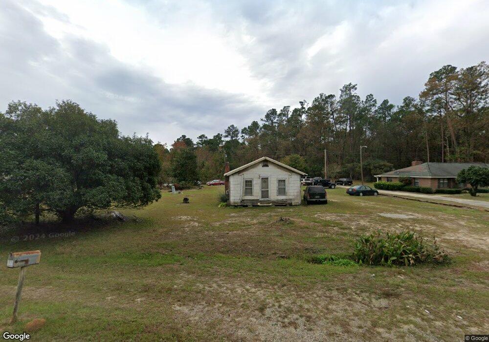
884 Newington Hwy Sylvania, GA 30467
Estimated Value: $66,000 - $249,876
--
Bed
1
Bath
921
Sq Ft
$148/Sq Ft
Est. Value
About This Home
This home is located at 884 Newington Hwy, Sylvania, GA 30467 and is currently estimated at $136,719, approximately $148 per square foot. 884 Newington Hwy is a home located in Screven County with nearby schools including Screven County Elementary School, Screven County Middle School, and Screven County High School.
Ownership History
Date
Name
Owned For
Owner Type
Purchase Details
Closed on
Aug 20, 2009
Sold by
Coles Mary Frances
Bought by
Taylor Ernest Jarald
Current Estimated Value
Purchase Details
Closed on
Aug 18, 2009
Sold by
Taylor Ernest Jarald
Bought by
Coles Mary Frances and Taylor Mosell
Purchase Details
Closed on
Dec 21, 1993
Sold by
Taylor Josie B
Bought by
Taylor Hazel H and James Taylor
Purchase Details
Closed on
Nov 14, 1955
Sold by
Black Mary Cheever
Bought by
Taylor James and Taylor Josie
Create a Home Valuation Report for This Property
The Home Valuation Report is an in-depth analysis detailing your home's value as well as a comparison with similar homes in the area
Home Values in the Area
Average Home Value in this Area
Purchase History
| Date | Buyer | Sale Price | Title Company |
|---|---|---|---|
| Taylor Ernest Jarald | -- | -- | |
| Coles Mary Frances | -- | -- | |
| Taylor Hazel H | -- | -- | |
| Taylor James | -- | -- |
Source: Public Records
Tax History Compared to Growth
Tax History
| Year | Tax Paid | Tax Assessment Tax Assessment Total Assessment is a certain percentage of the fair market value that is determined by local assessors to be the total taxable value of land and additions on the property. | Land | Improvement |
|---|---|---|---|---|
| 2024 | $108 | $3,080 | $2,040 | $1,040 |
| 2023 | $111 | $3,080 | $2,040 | $1,040 |
| 2022 | $106 | $2,920 | $2,040 | $880 |
| 2021 | $107 | $2,800 | $2,040 | $760 |
| 2020 | $83 | $2,760 | $2,040 | $720 |
| 2019 | $86 | $2,840 | $2,040 | $800 |
| 2018 | $80 | $2,800 | $2,040 | $760 |
| 2017 | $80 | $2,800 | $2,040 | $760 |
| 2016 | $192 | $2,932 | $2,040 | $892 |
| 2015 | -- | $3,132 | $2,040 | $1,092 |
| 2014 | -- | $3,092 | $2,040 | $1,052 |
| 2013 | -- | $3,092 | $2,040 | $1,052 |
Source: Public Records
Map
Nearby Homes
- 106 Lawton Place Dr
- LOT 125 Orange Ct
- 378 Lawton Rd
- 254 Country Club Rd
- 938 Rifle Rd
- 0 Friendship Rd Unit 10597657
- 0 Friendship Rd Unit SA339071
- 717 Lawton Rd
- 315 Cork Pond Rd
- 671 Waynesboro Hwy
- 0 Burtons Ferry Hwy Unit 10475688
- 0 Burtons Ferry Hwy Unit 10549042
- 258 Beardsville Rd
- 0 Dune Ln Unit SA331767
- 416 Abram St
- 222 Bridgeton Dr
- 501 N Main St
- 0 Poor Robin Unit 329695
- 850 Buttermilk Rd
- 406 N Main St
- 872 Newington Hwy
- 1029 Newington Hwy
- 1223 Newington Hwy
- 1001 Newington Hwy
- 467 Cedar Cir
- 1217 Newington Hwy
- 1230 Newington Hwy
- 195 Newbridge Rd
- 187 Newbridge Rd
- 106 Lawton Place Extension
- 0 Lawton Place Dr
- 463 Cedar Cir
- 181 Lawton Place Dr
- 1306 Newington Hwy
- 109 Lawton Place Extension
- 216 Lawton Place Dr
- 117 Lawton Place Dr
- 141 Banana Cir
- 1333 Newington Hwy
- 423 Mcbride Cir