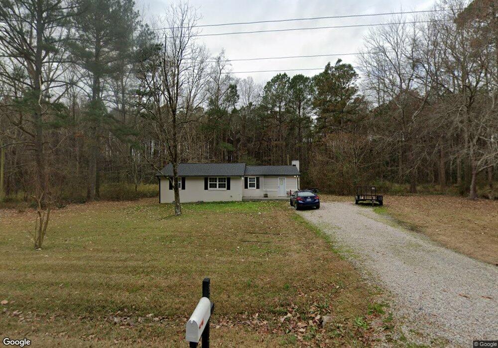
885 Barnes Rd Middlesex, NC 27557
Estimated Value: $240,000 - $271,000
3
Beds
1
Bath
1,156
Sq Ft
$222/Sq Ft
Est. Value
About This Home
This home is located at 885 Barnes Rd, Middlesex, NC 27557 and is currently estimated at $257,087, approximately $222 per square foot. 885 Barnes Rd is a home located in Johnston County with nearby schools including Corinth Holders Elementary School, Archer Lodge Middle School, and Corinth Holders High School.
Ownership History
Date
Name
Owned For
Owner Type
Purchase Details
Closed on
May 11, 2020
Sold by
State Employees Credit Union
Bought by
Secu Re Inc
Current Estimated Value
Purchase Details
Closed on
Aug 8, 2012
Sold by
Griggs Ronald J and Griggs Kathy A
Bought by
Narron Stephanie B and Narron Brandon L
Home Financials for this Owner
Home Financials are based on the most recent Mortgage that was taken out on this home.
Original Mortgage
$103,500
Interest Rate
3.55%
Mortgage Type
New Conventional
Create a Home Valuation Report for This Property
The Home Valuation Report is an in-depth analysis detailing your home's value as well as a comparison with similar homes in the area
Home Values in the Area
Average Home Value in this Area
Purchase History
| Date | Buyer | Sale Price | Title Company |
|---|---|---|---|
| Secu Re Inc | $70,500 | None Available | |
| Narron Stephanie B | $115,000 | None Available |
Source: Public Records
Mortgage History
| Date | Status | Borrower | Loan Amount |
|---|---|---|---|
| Previous Owner | Narron Stephanie B | $103,500 |
Source: Public Records
Tax History
| Year | Tax Paid | Tax Assessment Tax Assessment Total Assessment is a certain percentage of the fair market value that is determined by local assessors to be the total taxable value of land and additions on the property. | Land | Improvement |
|---|---|---|---|---|
| 2025 | $1,533 | $241,430 | $74,340 | $167,090 |
| 2024 | $945 | $116,620 | $35,680 | $80,940 |
| 2023 | $921 | $116,620 | $35,680 | $80,940 |
| 2022 | $945 | $116,620 | $35,680 | $80,940 |
| 2021 | $945 | $116,620 | $35,680 | $80,940 |
| 2020 | $812 | $96,620 | $35,680 | $60,940 |
| 2019 | $812 | $96,620 | $35,680 | $60,940 |
| 2018 | $710 | $82,520 | $32,710 | $49,810 |
| 2017 | $710 | $82,520 | $32,710 | $49,810 |
| 2016 | $710 | $82,520 | $32,710 | $49,810 |
| 2015 | $710 | $82,520 | $32,710 | $49,810 |
| 2014 | $710 | $82,520 | $32,710 | $49,810 |
Source: Public Records
Map
Nearby Homes
- 35 Chester Ln
- 6570 N Carolina 231
- 6571 N Carolina 231
- 0 Highway 231 Unit Off
- 216 Bullseye Ct
- 211 Bullseye Ct
- 197 Bullseye Ct
- 186 Bullseye Ct
- 126 Arrow Ln
- 248 Bullseye Ct
- 232 Bullseye Ct
- 174 Arrow Ln
- 144 S Sunny Dale Dr
- 54 Cupid Ct
- 70 Cupid Ct
- 55 Cupid Ct
- 258 Northview Dr Unit Lot 26
- 287 Northview Dr
- 64 Doughty Ln Unit E
- 11022 N Carolina 222
- 920 Barnes Rd Unit B
- 920 Barnes Rd Unit A
- 920 Barnes Rd Unit C
- 920 Barnes Rd
- 908 Barnes Rd
- 198 Rock River Ln
- 200 Rock River Ln
- 100 Rock River Ln
- 940 Barnes Rd
- 964 Barnes Rd
- 810 Barnes Rd
- 133 Rock River Ln
- 170 Brooke Ln
- 997 Barnes Rd
- 968 Barnes Rd
- 45 Chester Ln
- 1030 Barnes Rd
- 45 Barnes Rd
- 996 Barnes Rd
- 145 Brooke Ln
Your Personal Tour Guide
Ask me questions while you tour the home.