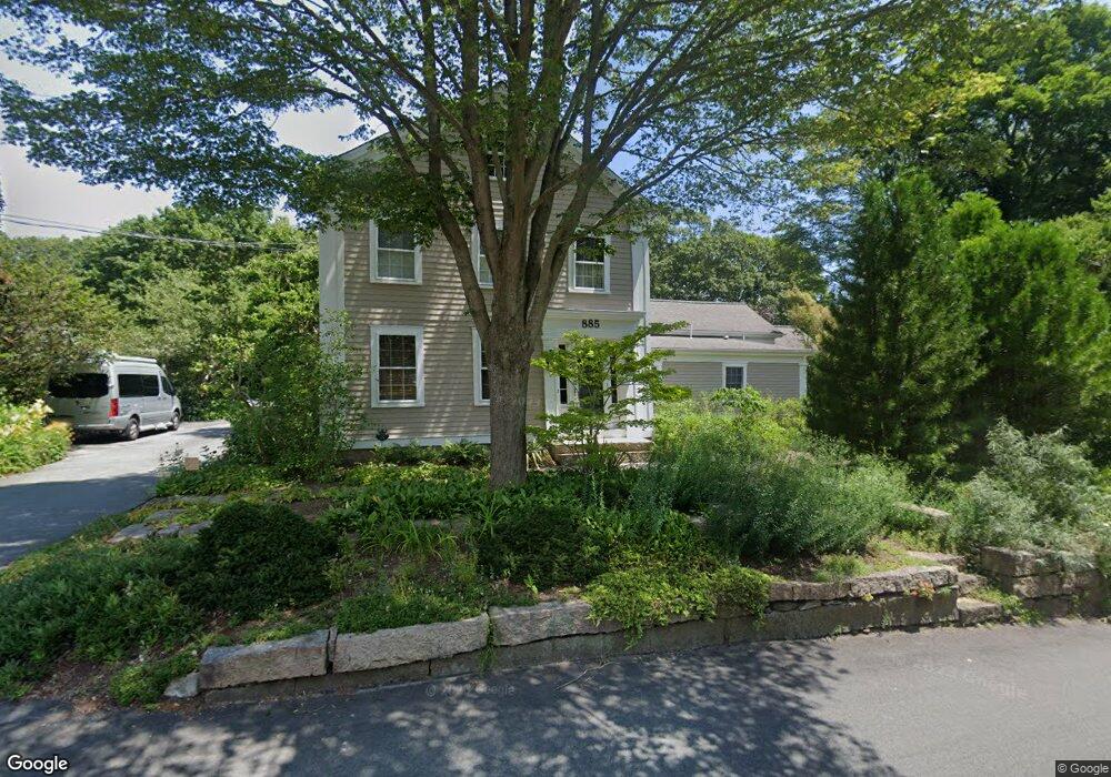
885 Rock Odundee Rd South Dartmouth, MA 02748
Cow Yard/Nonquitt NeighborhoodEstimated Value: $1,348,000 - $1,404,665
4
Beds
3
Baths
3,609
Sq Ft
$384/Sq Ft
Est. Value
About This Home
This home is located at 885 Rock Odundee Rd, South Dartmouth, MA 02748 and is currently estimated at $1,385,555, approximately $383 per square foot. 885 Rock Odundee Rd is a home located in Bristol County with nearby schools including Dartmouth High School.
Ownership History
Date
Name
Owned For
Owner Type
Purchase Details
Closed on
May 23, 2019
Sold by
Louise S Shwartz Ft
Bought by
Shwartz Larry T
Current Estimated Value
Purchase Details
Closed on
Apr 8, 2019
Sold by
Shwartz Larry T
Bought by
Larry T Shwartz Ft
Purchase Details
Closed on
Aug 30, 2013
Sold by
Shawartz Louise S and Shwartz Louis S
Bought by
Louise S Shwartz Ft and Shwartz Louis S
Purchase Details
Closed on
Apr 4, 2003
Sold by
Est Straus Charles B and Straus Gwyned F
Bought by
Shwartz Louise S
Home Financials for this Owner
Home Financials are based on the most recent Mortgage that was taken out on this home.
Original Mortgage
$320,000
Interest Rate
5.88%
Mortgage Type
Purchase Money Mortgage
Create a Home Valuation Report for This Property
The Home Valuation Report is an in-depth analysis detailing your home's value as well as a comparison with similar homes in the area
Home Values in the Area
Average Home Value in this Area
Purchase History
| Date | Buyer | Sale Price | Title Company |
|---|---|---|---|
| Shwartz Larry T | -- | -- | |
| Larry T Shwartz Ft | -- | -- | |
| Louise S Shwartz Ft | -- | -- | |
| Shwartz Louise S | $615,000 | -- |
Source: Public Records
Mortgage History
| Date | Status | Borrower | Loan Amount |
|---|---|---|---|
| Previous Owner | Shwartz Louise S | $320,000 | |
| Previous Owner | Shwartz Louise S | $170,000 | |
| Previous Owner | Shwartz Louise S | $170,000 | |
| Previous Owner | Shwartz Louise S | $175,000 |
Source: Public Records
Tax History Compared to Growth
Tax History
| Year | Tax Paid | Tax Assessment Tax Assessment Total Assessment is a certain percentage of the fair market value that is determined by local assessors to be the total taxable value of land and additions on the property. | Land | Improvement |
|---|---|---|---|---|
| 2025 | $10,467 | $1,135,300 | $415,200 | $720,100 |
| 2024 | $9,798 | $1,058,100 | $415,200 | $642,900 |
| 2023 | $9,310 | $940,400 | $346,000 | $594,400 |
| 2022 | $8,601 | $800,100 | $306,800 | $493,300 |
| 2021 | $8,885 | $799,000 | $291,300 | $507,700 |
| 2020 | $8,501 | $760,400 | $275,600 | $484,800 |
| 2019 | $8,044 | $721,400 | $264,400 | $457,000 |
| 2018 | $7,660 | $697,000 | $264,400 | $432,600 |
| 2017 | $7,478 | $687,300 | $249,600 | $437,700 |
| 2016 | $6,986 | $633,900 | $243,400 | $390,500 |
| 2015 | $7,047 | $640,600 | $245,600 | $395,000 |
| 2014 | $6,719 | $608,600 | $222,700 | $385,900 |
Source: Public Records
Map
Nearby Homes
- 1150 Russells Mills Rd
- 2 Slades Farm Ln
- Lot 2E Horseneck Rd
- 61 Pardon Hill Rd
- 248 Bakerville Rd
- Lot 1 Rafael Rd
- 24 White Alder Way
- 105 Rock Odundee Rd
- 34 Country Way
- 73 White Oak Run
- 75 Country Way Unit 75
- Lot 2 Horseneck Rd
- 14 Westview Dr
- 360 Russells Mills Rd
- 738 Smith Neck Rd
- 10 Westview Dr
- 482 Smith Neck Rd
- 99 Sylvia Ln
- 3 Mishawum Dr
- 5 Samosett Dr
- 889 Rock Odundee Rd
- 1228 Russells Mills Rd
- 893 Rock Odundee Rd
- 887 Rock Odundee Rd
- Lot 5-1 Horseneck
- 1200 Russells Mills Rd
- 4 Tannery Ln
- 2000 Fisher Rd
- 1219 Russells Mills Rd
- 7 Horseneck Rd
- 7 Horseneck Rd
- 1202 Russells Mills Rd
- 13 Horseneck Rd
- Lot 3A Yena Way
- Lot 5 Yena Way
- Lot 28 the Enclave
- Lots 7&14 Faunce Corner Rd
- 00 Confidential
- Lot 4 Yena Way
- Lot 3 Yena Way