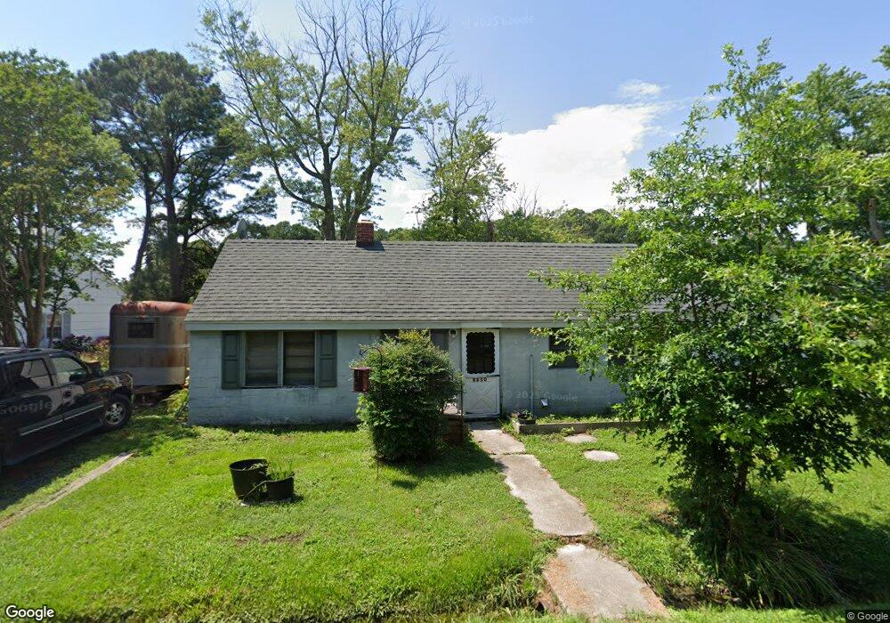
8850 Howeth Rd Wittman, MD 21676
Estimated Value: $140,941 - $296,000
Studio
--
Bath
964
Sq Ft
$246/Sq Ft
Est. Value
About This Home
This home is located at 8850 Howeth Rd, Wittman, MD 21676 and is currently estimated at $236,985, approximately $245 per square foot. 8850 Howeth Rd is a home located in Talbot County with nearby schools including Tilghman Elementary School, St. Michaels Middle/High School, and Easton High School.
Ownership History
Date
Name
Owned For
Owner Type
Purchase Details
Closed on
May 12, 1989
Sold by
Effinger Jeffrey K and Effinger Dorothy P
Bought by
Effinger Kenneth C and Effinger Marlene G
Current Estimated Value
Purchase Details
Closed on
Jun 15, 1983
Sold by
Effinger Kenneth C
Bought by
Effinger Jeffrey K and Effinger Dorothy P
Home Financials for this Owner
Home Financials are based on the most recent Mortgage that was taken out on this home.
Original Mortgage
$25,000
Interest Rate
12.82%
Create a Home Valuation Report for This Property
The Home Valuation Report is an in-depth analysis detailing your home's value as well as a comparison with similar homes in the area
Purchase History
| Date | Buyer | Sale Price | Title Company |
|---|---|---|---|
| Effinger Kenneth C | $19,400 | -- | |
| Effinger Jeffrey K | $25,000 | -- |
Source: Public Records
Mortgage History
| Date | Status | Borrower | Loan Amount |
|---|---|---|---|
| Previous Owner | Effinger Jeffrey K | $25,000 |
Source: Public Records
Tax History
| Year | Tax Paid | Tax Assessment Tax Assessment Total Assessment is a certain percentage of the fair market value that is determined by local assessors to be the total taxable value of land and additions on the property. | Land | Improvement |
|---|---|---|---|---|
| 2025 | $918 | $95,400 | $42,900 | $52,500 |
| 2024 | $882 | $91,800 | $0 | $0 |
| 2023 | $808 | $88,200 | $0 | $0 |
| 2022 | $726 | $84,600 | $42,900 | $41,700 |
| 2021 | $705 | $84,600 | $42,900 | $41,700 |
| 2020 | $688 | $84,600 | $42,900 | $41,700 |
| 2019 | $749 | $92,700 | $51,500 | $41,200 |
| 2018 | $711 | $90,700 | $0 | $0 |
| 2017 | $666 | $88,700 | $0 | $0 |
| 2016 | $617 | $86,700 | $0 | $0 |
| 2015 | $563 | $86,700 | $0 | $0 |
| 2014 | $563 | $86,700 | $0 | $0 |
Source: Public Records
Map
Nearby Homes
- 22582 Pot Pie Rd
- 8805 Cummings Rd
- 8915 Palmer Ln
- 22314 Pot Pie Rd
- 22707 Marshall Ln
- 22349 Cooper Ln
- 8781 Tilghman Island Rd
- 9262 Macks Ln
- 8620 Bozman Neavitt Rd
- 9681 Macks Ln
- 8034 Bozman Neavitt Rd
- 21869 Albie Rd
- 7651 Main St
- 23869 Mount Misery Rd
- 7508 Cooper Point Rd
- 23961 Lynnewood Dr
- 0 Cooper Point Rd Unit MDTA2013120
- 23857 Ebb Point Rd
- 9180 Saint Michaels Rd
- 24354 Widgeon Place Unit 20
- 8848 Howeth Rd
- 8844 Howeth Rd
- 0 Sewell Pt Rd Unit TA7806550
- 22580 Pot Pie Rd
- 22569 Pot Pie Rd
- 22561 Pot Pie Rd
- 8847 Howeth Rd
- 22597 Pot Pie Rd
- 22585 Pot Pie Rd
- 22555 Pot Pie Rd
- 22581 Pot Pie Rd
- 22595 Pot Pie Rd
- 8837 Howeth Rd
- 22590 Pot Pie Rd
- 0 Sewell Pt Rd Unit TA9616693
- PARCEL A Sewell Point Rd
- 22601 Pot Pie Rd
- 22572 Pot Pie Rd
- 22588 Pot Pie Rd
- 22600 Pot Pie Rd
Your Personal Tour Guide
Ask me questions while you tour the home.