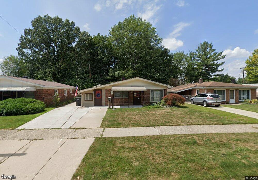
8850 Mason St Taylor, MI 48180
Estimated Value: $155,147 - $185,000
Studio
--
Bath
1,263
Sq Ft
$137/Sq Ft
Est. Value
About This Home
This home is located at 8850 Mason St, Taylor, MI 48180 and is currently estimated at $172,787, approximately $136 per square foot. 8850 Mason St is a home located in Wayne County with nearby schools including Clarence Randall Elementary School, Robert J. West Middle School, and Taylor Preparatory High School.
Ownership History
Date
Name
Owned For
Owner Type
Purchase Details
Closed on
May 22, 2023
Sold by
Rivera Patricia
Bought by
Aspenwall Noel-Charles and Aspenwall Annalyse
Current Estimated Value
Home Financials for this Owner
Home Financials are based on the most recent Mortgage that was taken out on this home.
Original Mortgage
$86,400
Outstanding Balance
$83,998
Interest Rate
6.39%
Estimated Equity
$88,789
Purchase Details
Closed on
Nov 1, 1990
Sold by
Przybyla Donna L
Bought by
Przybyla Donna L and Rivera Patricia J
Create a Home Valuation Report for This Property
The Home Valuation Report is an in-depth analysis detailing your home's value as well as a comparison with similar homes in the area
Home Values in the Area
Average Home Value in this Area
Purchase History
| Date | Buyer | Sale Price | Title Company |
|---|---|---|---|
| Aspenwall Noel-Charles | $108,000 | Michigan Title Insurance Agenc | |
| Przybyla Donna L | -- | None Listed On Document |
Source: Public Records
Mortgage History
| Date | Status | Borrower | Loan Amount |
|---|---|---|---|
| Open | Aspenwall Noel-Charles | $86,400 |
Source: Public Records
Tax History
| Year | Tax Paid | Tax Assessment Tax Assessment Total Assessment is a certain percentage of the fair market value that is determined by local assessors to be the total taxable value of land and additions on the property. | Land | Improvement |
|---|---|---|---|---|
| 2025 | $1,717 | $83,600 | $0 | $0 |
| 2024 | $1,663 | $80,100 | $0 | $0 |
| 2023 | $1,846 | $70,200 | $0 | $0 |
| 2022 | $1,587 | $60,000 | $0 | $0 |
| 2021 | $1,746 | $52,700 | $0 | $0 |
| 2020 | $1,728 | $49,200 | $0 | $0 |
| 2019 | $172,789 | $45,800 | $0 | $0 |
| 2018 | $1,362 | $34,800 | $0 | $0 |
| 2017 | $738 | $34,800 | $0 | $0 |
| 2016 | $1,684 | $33,800 | $0 | $0 |
| 2015 | $3,078 | $32,100 | $0 | $0 |
| 2013 | $3,060 | $31,800 | $0 | $0 |
| 2012 | $1,351 | $31,300 | $8,500 | $22,800 |
Source: Public Records
Map
Nearby Homes
- 8953 William St
- 21059 Wick Rd
- 20812 Wick Rd
- 8944 William St
- 20548 Lockwood St
- 9444 Polk St
- 8281 Huron St
- 9134 Weddel St
- 9127 Weddel St
- 9223 Roosevelt St
- 7972 Hipp St
- 22137 Haskell St
- 9640 Dudley St
- 22134 Wick Rd
- 8245 Roosevelt St
- 8711 Jackson St
- 22185 Wick Rd
- 7882 Campbell St
- 8935 Lincoln St
- 20234 Champaign St
- 8840 Mason St
- 8860 Mason St
- 8900 Mason St
- 8830 Mason St
- 8845 Mason St
- 8861 Mason St
- 8820 Mason St
- 8917 Mortenview Dr
- 8920 Mason St
- 9005 Mason St
- 20999 Millard St
- 20993 Millard St
- 21048 Lockwood St
- 20985 Millard St
- 8932 Mason St
- 9019 Mason St
- 8805 Mortenview Dr
- 21036 Lockwood St
- 8935 Mortenview Dr
- 20977 Millard St
Your Personal Tour Guide
Ask me questions while you tour the home.