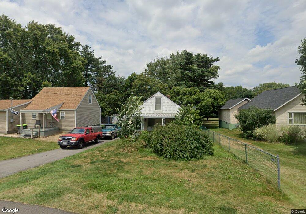
8885 Scott St Louisville, OH 44641
Estimated Value: $92,000 - $125,000
2
Beds
1
Bath
836
Sq Ft
$127/Sq Ft
Est. Value
About This Home
This home is located at 8885 Scott St, Louisville, OH 44641 and is currently estimated at $105,767, approximately $126 per square foot. 8885 Scott St is a home located in Stark County with nearby schools including Louisville High School and St. Thomas Aquinas High School & Middle School.
Ownership History
Date
Name
Owned For
Owner Type
Purchase Details
Closed on
Apr 9, 2004
Sold by
Hud
Bought by
Frame Catherine S
Current Estimated Value
Home Financials for this Owner
Home Financials are based on the most recent Mortgage that was taken out on this home.
Original Mortgage
$42,097
Outstanding Balance
$19,810
Interest Rate
5.66%
Mortgage Type
FHA
Estimated Equity
$85,957
Purchase Details
Closed on
Feb 28, 2003
Sold by
Smith Robert L and Shuster Debra L
Bought by
Hud
Purchase Details
Closed on
May 2, 2002
Sold by
Smith Robert L
Bought by
Hud
Purchase Details
Closed on
Jul 19, 1999
Sold by
Smith Robert L and Nims Tracy M
Bought by
Smith Robert L
Home Financials for this Owner
Home Financials are based on the most recent Mortgage that was taken out on this home.
Original Mortgage
$60,800
Interest Rate
7.54%
Mortgage Type
FHA
Purchase Details
Closed on
Mar 9, 1998
Sold by
Smith Robert L
Bought by
Nims Robert L Smith Tracy M
Home Financials for this Owner
Home Financials are based on the most recent Mortgage that was taken out on this home.
Original Mortgage
$47,853
Interest Rate
7.08%
Mortgage Type
FHA
Create a Home Valuation Report for This Property
The Home Valuation Report is an in-depth analysis detailing your home's value as well as a comparison with similar homes in the area
Home Values in the Area
Average Home Value in this Area
Purchase History
| Date | Buyer | Sale Price | Title Company |
|---|---|---|---|
| Frame Catherine S | $41,000 | -- | |
| Hud | $38,000 | -- | |
| Hud | $38,000 | -- | |
| Smith Robert L | -- | -- | |
| Nims Robert L Smith Tracy M | $48,105 | -- |
Source: Public Records
Mortgage History
| Date | Status | Borrower | Loan Amount |
|---|---|---|---|
| Open | Frame Catherine S | $42,097 | |
| Previous Owner | Smith Robert L | $60,800 | |
| Previous Owner | Nims Robert L Smith Tracy M | $47,853 |
Source: Public Records
Tax History Compared to Growth
Tax History
| Year | Tax Paid | Tax Assessment Tax Assessment Total Assessment is a certain percentage of the fair market value that is determined by local assessors to be the total taxable value of land and additions on the property. | Land | Improvement |
|---|---|---|---|---|
| 2025 | -- | $22,480 | $5,850 | $16,630 |
| 2024 | -- | $22,480 | $5,850 | $16,630 |
| 2023 | $959 | $19,250 | $4,130 | $15,120 |
| 2022 | $964 | $19,250 | $4,130 | $15,120 |
| 2021 | $967 | $19,250 | $4,130 | $15,120 |
| 2020 | $827 | $17,330 | $3,750 | $13,580 |
| 2019 | $831 | $17,330 | $3,750 | $13,580 |
| 2018 | $828 | $17,330 | $3,750 | $13,580 |
| 2017 | $773 | $15,440 | $3,500 | $11,940 |
| 2016 | $757 | $15,440 | $3,500 | $11,940 |
| 2015 | $759 | $15,440 | $3,500 | $11,940 |
| 2014 | $715 | $13,450 | $3,050 | $10,400 |
| 2013 | $361 | $13,450 | $3,050 | $10,400 |
Source: Public Records
Map
Nearby Homes
- 2015 E Main St
- 5495 Meese Rd NE
- 1413 Washington Blvd
- 0 Michigan Blvd
- 1812 E Broad St
- 6052 N Nickelplate St
- 910 Crosswyck Cir
- 308 Superior St
- 2110 Edmar St
- 344 E Reno Dr
- 520 S Silver St
- 316 E Reno Dr
- 325 Lincoln Ave
- 728 E Broad St
- 5765 Maplegrove St
- 428 Honeycrisp Dr NE
- 3047 Mcintosh Dr NE
- 432 Honeycrisp Dr NE
- 2962 Mcintosh Dr NE
- 2963 Mcintosh Dr NE