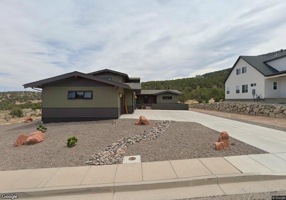
889 S 1600 Parowan, UT 84761
Estimated Value: $735,093 - $2,266,000
--
Bed
--
Bath
--
Sq Ft
0.44
Acres
About This Home
This home is located at 889 S 1600, Parowan, UT 84761 and is currently estimated at $1,397,364. 889 S 1600 is a home located in Iron County with nearby schools including Parowan School, Parowan High School, and Cedar City High School.
Ownership History
Date
Name
Owned For
Owner Type
Purchase Details
Closed on
May 30, 2024
Sold by
Hill Marx David and Lynn Marx Brenna
Bought by
Marx David H and Marx Brenna L
Current Estimated Value
Home Financials for this Owner
Home Financials are based on the most recent Mortgage that was taken out on this home.
Original Mortgage
$691,000
Outstanding Balance
$682,316
Interest Rate
7.1%
Mortgage Type
New Conventional
Estimated Equity
$715,048
Purchase Details
Closed on
Jul 19, 2022
Sold by
Old Spanish Trail Estate Llc
Bought by
Marx David Hill and Marx Brenna Lynn
Create a Home Valuation Report for This Property
The Home Valuation Report is an in-depth analysis detailing your home's value as well as a comparison with similar homes in the area
Home Values in the Area
Average Home Value in this Area
Purchase History
| Date | Buyer | Sale Price | Title Company |
|---|---|---|---|
| Marx David H | -- | Security Escrow & Title | |
| Marx David Hill | -- | Southern Utah Title |
Source: Public Records
Mortgage History
| Date | Status | Borrower | Loan Amount |
|---|---|---|---|
| Open | Marx David H | $691,000 |
Source: Public Records
Tax History Compared to Growth
Tax History
| Year | Tax Paid | Tax Assessment Tax Assessment Total Assessment is a certain percentage of the fair market value that is determined by local assessors to be the total taxable value of land and additions on the property. | Land | Improvement |
|---|---|---|---|---|
| 2025 | $3,980 | $494,028 | $64,625 | $429,403 |
| 2023 | $3,477 | $124,350 | $124,350 | $0 |
| 2022 | $1,082 | $113,040 | $113,040 | $0 |
| 2021 | $503 | $52,575 | $52,575 | $0 |
| 2020 | $447 | $41,255 | $41,255 | $0 |
| 2019 | $469 | $41,255 | $41,255 | $0 |
| 2018 | $416 | $35,875 | $35,875 | $0 |
| 2017 | $427 | $35,875 | $35,875 | $0 |
| 2016 | $451 | $35,875 | $35,875 | $0 |
| 2015 | $454 | $34,145 | $0 | $0 |
| 2014 | $476 | $34,145 | $0 | $0 |
Source: Public Records
Map
Nearby Homes
- 1521 W 950 S
- 701 S Heritage Hills Dr
- 704 S Heritage Hills Dr
- 680 S Heritage Hills Dr
- 0 W Old Highway 91 Unit 24-253616
- 0 W Old Highway 91 Unit 108031
- 403 & 404 Kari
- 1025 W Old Highway 91
- 377 1375 W
- 6 Acres Commercial Land
- 1435 W 200 S Unit 315
- 0 Pine Canyon Dr Unit 25-260421
- 1144 375 South St
- 1112 W 275 S
- 2239 W 475 S
- 257 S 1175 W
- 2228 W 450 S
- 2246 W 450 S
- 0 Lot 2 Blk 8 Plat C Unit 108795
- 6.81 ACFT Water Right: 75-251 Unit 1915 Priority
- 889 S 1600 Unit 27
- 871 S 1600 W Unit 1
- 871 S 1600 Unit 26
- 871 S 1600 W Unit Lot 26
- 871 S 1600 W
- 871 S 1600
- 907 S 1600 W
- 921 S 1600 W Unit 1
- 921 S 1600 W Unit Lot 29
- 921 S 1600 W
- 921 S 1600
- 921 S 1600 Unit 29
- 859 S 1600
- 859 S 1600 Unit 25
- 841 S 1600
- 841 S 1600 Unit 24
- 939 S 1600
- 939 S 1600 Unit 30
- 1200 S 1600 W
- 975 S 1600 W