Estimated Value: $442,000 - $578,908
3
Beds
1
Bath
962
Sq Ft
$523/Sq Ft
Est. Value
About This Home
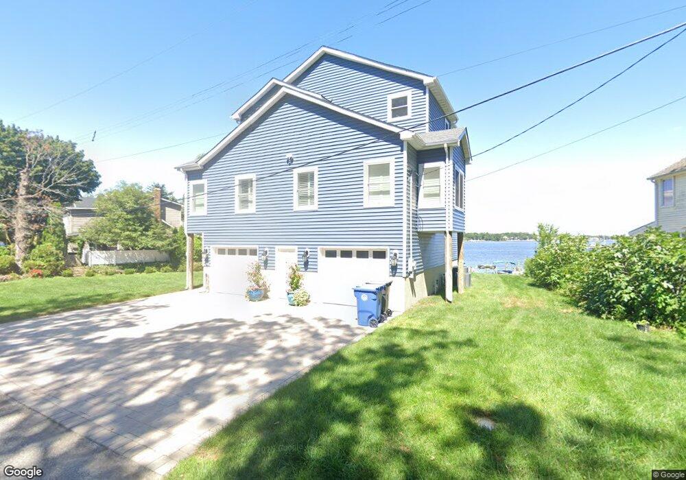
This home is located at 89 Edwards Rd, Brick, NJ 08723 and is currently estimated at $502,727, approximately $522 per square foot. 89 Edwards Rd is a home located in Ocean County with nearby schools including Emma Havens Young Elementary School, Lake Riviera Middle School, and Brick Township High School.
Ownership History
Date
Name
Owned For
Owner Type
Purchase Details
Closed on
Dec 14, 2023
Sold by
Kallos Joan A
Bought by
Joan A Kallos Revocable Trust and Kallos
Current Estimated Value
Purchase Details
Closed on
Dec 23, 2020
Sold by
Roshak David E and Roshak Arlene M
Bought by
Kallos Peter C and Kallos Joan A
Purchase Details
Closed on
Feb 20, 2019
Sold by
Law Purwin Investment Group
Bought by
Roshak David E and Roshak Arlene M
Purchase Details
Closed on
Apr 13, 2015
Sold by
Geddes John
Bought by
Law Purwin Investment Group
Purchase Details
Closed on
Jun 7, 1995
Sold by
Bertrand Donald
Bought by
Geddes John
Home Financials for this Owner
Home Financials are based on the most recent Mortgage that was taken out on this home.
Original Mortgage
$100,000
Interest Rate
8.24%
Create a Home Valuation Report for This Property
The Home Valuation Report is an in-depth analysis detailing your home's value as well as a comparison with similar homes in the area
Home Values in the Area
Average Home Value in this Area
Purchase History
| Date | Buyer | Sale Price | Title Company |
|---|---|---|---|
| Joan A Kallos Revocable Trust | -- | None Listed On Document | |
| Joan A Kallos Revocable Trust | -- | None Listed On Document | |
| Kallos Peter C | $185,000 | None Listed On Document | |
| Roshak David E | $150,000 | Stewart Title Insurance Co | |
| Law Purwin Investment Group | $183,702 | Attorney | |
| Geddes John | $100,000 | -- |
Source: Public Records
Mortgage History
| Date | Status | Borrower | Loan Amount |
|---|---|---|---|
| Previous Owner | Geddes John | $100,000 |
Source: Public Records
Tax History
| Year | Tax Paid | Tax Assessment Tax Assessment Total Assessment is a certain percentage of the fair market value that is determined by local assessors to be the total taxable value of land and additions on the property. | Land | Improvement |
|---|---|---|---|---|
| 2025 | $12,039 | $466,100 | $117,200 | $348,900 |
| 2024 | $11,443 | $466,100 | $117,200 | $348,900 |
| 2023 | $2,840 | $117,200 | $117,200 | $0 |
| 2022 | $2,840 | $117,200 | $117,200 | $0 |
| 2021 | $2,780 | $117,200 | $117,200 | $0 |
| 2020 | $2,745 | $117,200 | $117,200 | $0 |
| 2019 | $2,699 | $117,200 | $117,200 | $0 |
| 2018 | $2,637 | $117,200 | $117,200 | $0 |
| 2017 | $2,566 | $117,200 | $117,200 | $0 |
| 2016 | $2,553 | $117,200 | $117,200 | $0 |
| 2015 | $3,811 | $179,700 | $117,200 | $62,500 |
| 2014 | $3,781 | $179,700 | $117,200 | $62,500 |
Source: Public Records
Map
Nearby Homes
- 35 Hampton Rd
- 592 Kingfisher Cir
- 683 Mantoloking Rd
- 638 Ivanhoe Rd
- 4 Mayfair Ct
- 580 Kingfisher Cir
- 578 Kingfisher Cir
- 11 Cedar Rd
- 19 Moholo Ct Unit 19
- 9 Bayberry Ave
- 24 Unity Dr
- 458 E End Ave
- 307 Drum Point Rd
- 3 Metedeconk Rd
- 23 Island Dr
- 0 Island Ct
- 230 Drum Point Rd
- 10 Riverside Dr W
- 299 Huppert Dr
- 353 Arrowhead Dr
Your Personal Tour Guide
Ask me questions while you tour the home.