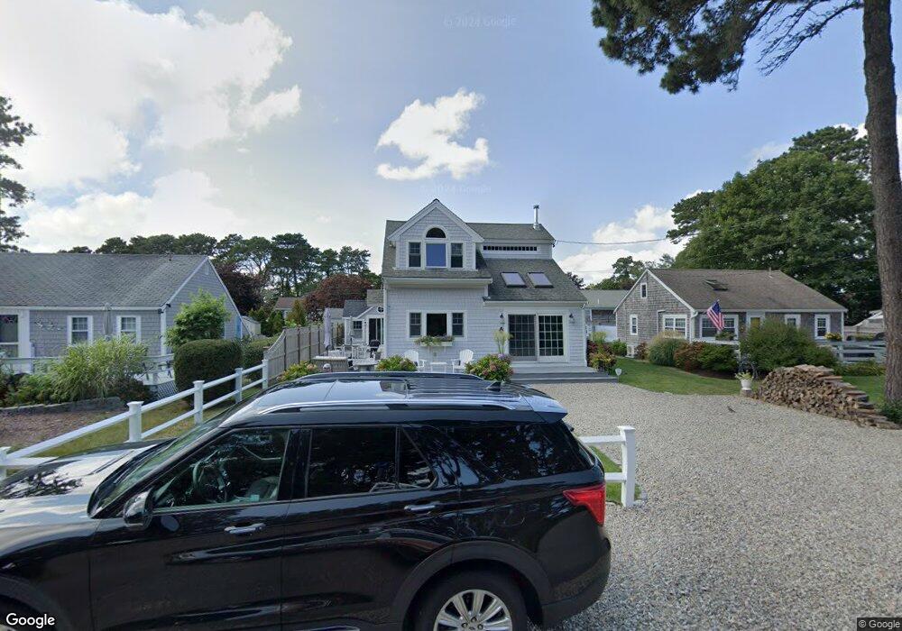
89 Siasconset Ave Dennis Port, MA 02639
Dennis Port NeighborhoodEstimated Value: $582,000 - $767,000
2
Beds
1
Bath
800
Sq Ft
$890/Sq Ft
Est. Value
About This Home
This home is located at 89 Siasconset Ave, Dennis Port, MA 02639 and is currently estimated at $712,367, approximately $890 per square foot. 89 Siasconset Ave is a home located in Barnstable County with nearby schools including Dennis-Yarmouth Regional High School and St. Pius X. School.
Ownership History
Date
Name
Owned For
Owner Type
Purchase Details
Closed on
Jul 26, 2021
Sold by
Oconnor James F and Oconnor Janice M
Bought by
Oconnor Nt 2021 and Oconnor
Current Estimated Value
Purchase Details
Closed on
May 5, 1998
Sold by
Rutteman Marten H and Rutteman Marie T
Bought by
Oconnor James F and Oconnor Janice M
Home Financials for this Owner
Home Financials are based on the most recent Mortgage that was taken out on this home.
Original Mortgage
$67,500
Interest Rate
7.04%
Mortgage Type
Purchase Money Mortgage
Create a Home Valuation Report for This Property
The Home Valuation Report is an in-depth analysis detailing your home's value as well as a comparison with similar homes in the area
Home Values in the Area
Average Home Value in this Area
Purchase History
| Date | Buyer | Sale Price | Title Company |
|---|---|---|---|
| Oconnor Nt 2021 | -- | None Available | |
| Oconnor James F | $75,000 | -- |
Source: Public Records
Mortgage History
| Date | Status | Borrower | Loan Amount |
|---|---|---|---|
| Previous Owner | Oconnor James F | $67,500 |
Source: Public Records
Tax History Compared to Growth
Tax History
| Year | Tax Paid | Tax Assessment Tax Assessment Total Assessment is a certain percentage of the fair market value that is determined by local assessors to be the total taxable value of land and additions on the property. | Land | Improvement |
|---|---|---|---|---|
| 2025 | $2,789 | $644,000 | $191,800 | $452,200 |
| 2024 | $2,735 | $623,100 | $184,400 | $438,700 |
| 2023 | $2,647 | $566,800 | $167,700 | $399,100 |
| 2022 | $2,425 | $433,000 | $151,000 | $282,000 |
| 2021 | $2,489 | $412,800 | $169,200 | $243,600 |
| 2020 | $2,322 | $380,600 | $148,100 | $232,500 |
| 2019 | $2,172 | $352,100 | $145,200 | $206,900 |
| 2018 | $2,144 | $338,100 | $138,200 | $199,900 |
| 2017 | $2,018 | $328,200 | $128,300 | $199,900 |
| 2016 | $2,015 | $308,500 | $138,200 | $170,300 |
| 2015 | $1,974 | $308,500 | $138,200 | $170,300 |
| 2014 | $1,799 | $283,300 | $118,500 | $164,800 |
Source: Public Records
Map
Nearby Homes
- 31 Easy St
- 80 Michaels Ave
- 22 Wixon Rd
- 19 Standish Way
- 37 Ocean Dr Unit 2
- 64 Beaten Rd
- 154 Old Wharf Rd Unit 26
- 154 Old Wharf Rd Unit 14
- 112 Old Wharf Rd Unit E4
- 112 Old Wharf Rd Unit E1
- 37 Beach Hills Rd
- 262 Old Wharf Rd Unit 67
- 262 Old Wharf Rd Unit 5
- 262 Old Wharf Rd Unit 5
- 262 Old Wharf Rd Unit 20
- 262 Old Wharf Rd Unit 87
- 4 Coffey Ln
- 37-A Beach Hills Rd
- 120 Old Wharf Rd Unit 11
- 217 Old Wharf Rd Unit 64
- 85 Siasconset Ave
- 91 Siasconset Ave
- 98 Cynthia Ln
- 83 Siasconset Ave
- 93 Siasconset Ave
- 104 Cynthia Ln
- 81 Siasconset Ave
- 95 Siasconset Ave
- 103 Cynthia Ln
- 97 Cynthia Ln
- 97-A Cynthia Ln
- 92 Cynthia Ln
- 79 Siasconset Ave
- 97 Siasconset Ave
- 112 Cynthia Ln
- 111 Cynthia Ln
- 77 Siasconset Ave
- 99 Siasconset Ave
- 81 Captain Chase Rd
- 79 Captain Chase Rd