Estimated Value: $88,000 - $122,000
3
Beds
2
Baths
1,300
Sq Ft
$81/Sq Ft
Est. Value
About This Home
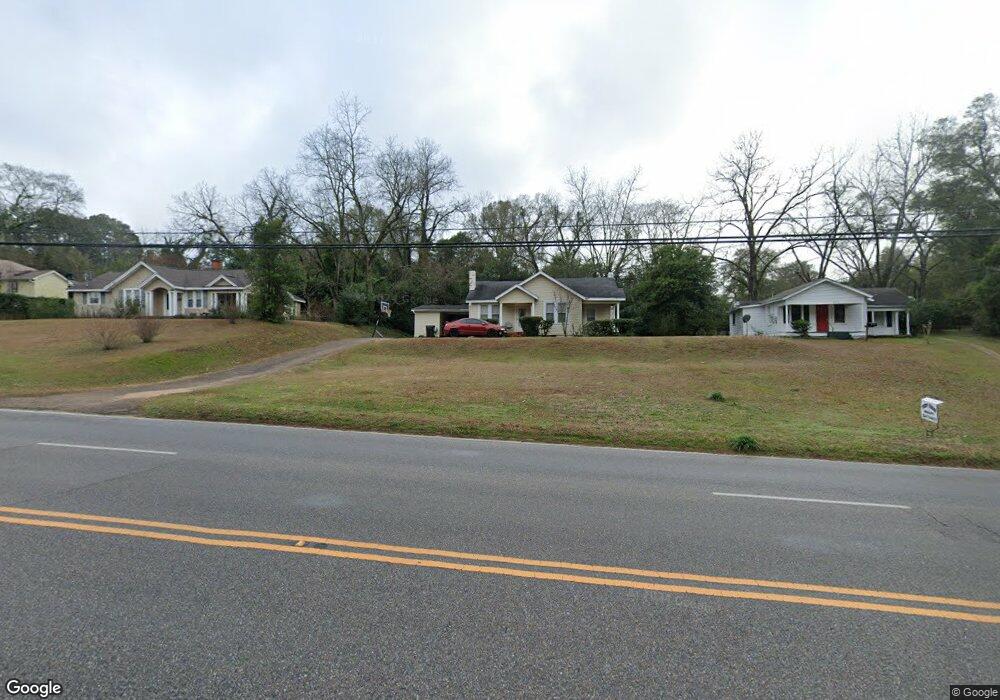
This home is located at 890 S Union Ave, Ozark, AL 36360 and is currently estimated at $104,780, approximately $80 per square foot. 890 S Union Ave is a home located in Dale County with nearby schools including Lisenby Primary School, Mixon Intermediate School, and D. A. Smith Middle School.
Ownership History
Date
Name
Owned For
Owner Type
Purchase Details
Closed on
Aug 5, 2021
Sold by
Sect Real Estate Holdings Llc
Bought by
Gaud German
Current Estimated Value
Purchase Details
Closed on
Jan 20, 2021
Sold by
Watson Deanna
Bought by
Sect Real Estate Holdings Llc
Home Financials for this Owner
Home Financials are based on the most recent Mortgage that was taken out on this home.
Original Mortgage
$65,000
Interest Rate
2.7%
Mortgage Type
New Conventional
Purchase Details
Closed on
Dec 21, 2020
Sold by
Flinn Joanna
Bought by
Olive Frederick E
Home Financials for this Owner
Home Financials are based on the most recent Mortgage that was taken out on this home.
Original Mortgage
$65,000
Interest Rate
2.7%
Mortgage Type
New Conventional
Purchase Details
Closed on
Nov 18, 2019
Sold by
Wood Marsha and Olive Fredrick Ernest
Bought by
Flinn Joann
Create a Home Valuation Report for This Property
The Home Valuation Report is an in-depth analysis detailing your home's value as well as a comparison with similar homes in the area
Home Values in the Area
Average Home Value in this Area
Purchase History
| Date | Buyer | Sale Price | Title Company |
|---|---|---|---|
| Gaud German | $46,000 | None Available | |
| Sect Real Estate Holdings Llc | $28,750 | None Available | |
| Olive Frederick E | -- | None Available | |
| Flinn Joann | -- | None Available |
Source: Public Records
Mortgage History
| Date | Status | Borrower | Loan Amount |
|---|---|---|---|
| Previous Owner | Olive Frederick E | $65,000 |
Source: Public Records
Tax History Compared to Growth
Tax History
| Year | Tax Paid | Tax Assessment Tax Assessment Total Assessment is a certain percentage of the fair market value that is determined by local assessors to be the total taxable value of land and additions on the property. | Land | Improvement |
|---|---|---|---|---|
| 2024 | $414 | $8,200 | $600 | $7,600 |
| 2023 | $414 | $7,160 | $600 | $6,560 |
| 2022 | $297 | $5,880 | $1,000 | $4,880 |
| 2021 | $554 | $10,980 | $1,200 | $9,780 |
| 2020 | $223 | $5,900 | $600 | $5,300 |
| 2019 | $244 | $5,900 | $600 | $5,300 |
| 2018 | $224 | $5,500 | $600 | $4,900 |
| 2017 | $224 | $5,500 | $600 | $4,900 |
| 2016 | $224 | $5,500 | $600 | $4,900 |
| 2015 | $224 | $5,500 | $600 | $4,900 |
| 2014 | $220 | $5,420 | $600 | $4,820 |
| 2013 | $218 | $5,420 | $600 | $4,820 |
Source: Public Records
Map
Nearby Homes
- 166 Garner Dr
- 236 Choctaw Ave
- 129 Jackson St
- 00 Lot 9 & 10 Sandy Hill
- 729 Pine Ave
- 0 Briar Cliff Dr Lot 1 Blk D
- 152 Short Pine Ave
- 00
- 0 Briar Cliff Rd Lot 5 Bk E
- 0000 Magnolia St
- 252 Del Rio Terrace
- 00 Fairview Street Oak Ave
- 0 Del Rio Terrace
- 216 Ketcham St
- 471 Magnolia St
- 124 Sandy Hills Ct
- Harry Walker Rd
- 254 Newton Ave
- 446 W College St
- 179 Dixie Dr
- 878 S Union Ave
- 910 S Union Ave
- 413 Tanyard St
- 413 Tanyard St
- 413 Tanyard Ave
- 926 S Union Ave
- 944 S Union Ave
- 421 Tanyard St
- 146 Tanyard Ave
- 00 Hwy 33 at Mary McClendon Rd
- 0 Briarcliff Rd Lots 12-13 Unit 187783
- N/A Hampton Place
- 419 Tanyard St
- 417 Tanyard St
- 2373 S Us Highway 231
- 120 Tanyard Ave
- 972 S Highway 123 Unit C0
- 928 S Union Ave
- 153 Tanyard Ave
- 965 Newton Ave