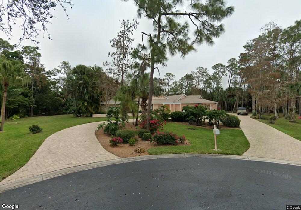
890 Swallow Point Unit 47 Naples, FL 34105
Moorings Park-Hawks Ridge NeighborhoodEstimated Value: $871,000 - $924,792
3
Beds
3
Baths
2,657
Sq Ft
$335/Sq Ft
Est. Value
About This Home
This home is located at 890 Swallow Point Unit 47, Naples, FL 34105 and is currently estimated at $889,448, approximately $334 per square foot. 890 Swallow Point Unit 47 is a home located in Collier County with nearby schools including Osceola Elementary School, Pine Ridge Middle School, and Barron Collier High School.
Ownership History
Date
Name
Owned For
Owner Type
Purchase Details
Closed on
Aug 22, 2025
Sold by
Bailey David E
Bought by
Theodore E Troe Estate Trust and Eve Mara Estate Trust
Current Estimated Value
Purchase Details
Closed on
May 22, 2023
Sold by
C & D Partnership Llc
Bought by
Bailey David E
Purchase Details
Closed on
Dec 31, 2018
Sold by
C And P Partnership Lllp
Bought by
C And D Partnership Llc
Create a Home Valuation Report for This Property
The Home Valuation Report is an in-depth analysis detailing your home's value as well as a comparison with similar homes in the area
Home Values in the Area
Average Home Value in this Area
Purchase History
| Date | Buyer | Sale Price | Title Company |
|---|---|---|---|
| Theodore E Troe Estate Trust | $860,000 | Cottrell Title & Escrow | |
| Bailey David E | -- | None Listed On Document | |
| Bailey David E | -- | None Listed On Document | |
| C And D Partnership Llc | -- | Attorney |
Source: Public Records
Map
Nearby Homes
- 700 Bald Eagle Dr Unit 37
- 740 Bald Eagle Dr Unit 40
- 1044 Woodshire Ln Unit 205
- 1096 Woodshire Ln Unit 205
- 1096 Woodshire Ln Unit 210
- 640 Jacana Cir Unit 28
- 628 Woodshire Ln Unit G12
- 628 Woodshire Ln Unit G4
- 1562 Oyster Catcher Point Unit 1562
- 2341 Mayfield Ct Unit 8
- 2383 Mayfield Ct Unit 4
- 190 Turtle Lake Ct Unit 311
- 190 Turtle Lake Ct Unit 202
- 1554 Oyster Catcher Point Unit 1554-C
- 325 Imperial Wilder Blvd
- 1538 Oyster Catcher Point Unit 1538
- 117 Bobolink Way Unit 17A
- 1529 Oyster Catcher Point Unit 1529
- 1057 Forest Lakes Dr Unit 209
- 1057 Forest Lakes Dr Unit 1208
- 760 Bald Eagle Dr Unit 42
- 831 Swallow Point Unit 50
- 700 Bald Eagle Dr
- 1021 Oriole Cir Unit 63
- 1041 Oriole Cir Unit 61
- 1050 Oriole Cir
- 1030 Oriole Cir Unit 57
- 1010 Oriole Cir Unit 55
- 900 Bald Eagle Dr Unit 52
- 801 Swallow Point Unit 51
- 890 Swallow Point
- 860 Swallow Point Unit 46
- 830 Swallow Point Unit 45
- 760 Bald Eagle Dr
- 750 Bald Eagle Dr Unit 41
- 720 Bald Eagle Dr Unit 39
- 831 Swallow Point
- 760 Bald Eagle Dr Unit 11
- 900 Bald Eagle Dr Unit 11
- 720 Bald Eagle Dr Unit 601
Your Personal Tour Guide
Ask me questions while you tour the home.