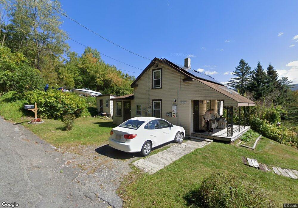
890 W Cross Rd Clarksburg, MA 01247
Estimated Value: $171,310 - $222,000
2
Beds
1
Bath
836
Sq Ft
$227/Sq Ft
Est. Value
About This Home
This home is located at 890 W Cross Rd, Clarksburg, MA 01247 and is currently estimated at $189,828, approximately $227 per square foot. 890 W Cross Rd is a home located in Berkshire County with nearby schools including Clarksburg Elementary School.
Ownership History
Date
Name
Owned For
Owner Type
Purchase Details
Closed on
Jan 5, 1993
Sold by
Hazard John and Hazard Robert J
Bought by
Worth William H and Wroth Joan M
Current Estimated Value
Home Financials for this Owner
Home Financials are based on the most recent Mortgage that was taken out on this home.
Original Mortgage
$30,750
Interest Rate
8.32%
Mortgage Type
Purchase Money Mortgage
Create a Home Valuation Report for This Property
The Home Valuation Report is an in-depth analysis detailing your home's value as well as a comparison with similar homes in the area
Home Values in the Area
Average Home Value in this Area
Purchase History
| Date | Buyer | Sale Price | Title Company |
|---|---|---|---|
| Worth William H | $44,000 | -- |
Source: Public Records
Mortgage History
| Date | Status | Borrower | Loan Amount |
|---|---|---|---|
| Open | Worth William H | $20,500 | |
| Closed | Worth William H | $10,250 | |
| Closed | Worth William H | $6,533 | |
| Closed | Worth William H | $30,750 | |
| Closed | Worth William H | $6,630 |
Source: Public Records
Tax History Compared to Growth
Tax History
| Year | Tax Paid | Tax Assessment Tax Assessment Total Assessment is a certain percentage of the fair market value that is determined by local assessors to be the total taxable value of land and additions on the property. | Land | Improvement |
|---|---|---|---|---|
| 2025 | $1,425 | $104,900 | $38,200 | $66,700 |
| 2024 | $1,507 | $98,200 | $32,900 | $65,300 |
| 2023 | $1,478 | $95,600 | $32,900 | $62,700 |
| 2022 | $1,490 | $90,400 | $32,900 | $57,500 |
| 2021 | $1,346 | $85,100 | $32,900 | $52,200 |
| 2020 | $1,646 | $92,000 | $40,000 | $52,000 |
| 2019 | $1,456 | $91,100 | $39,600 | $51,500 |
| 2018 | $1,402 | $91,600 | $39,600 | $52,000 |
| 2016 | $1,276 | $83,300 | $41,300 | $42,000 |
| 2015 | $1,258 | $89,300 | $44,400 | $44,900 |
| 2014 | $1,193 | $89,300 | $44,400 | $44,900 |
Source: Public Records
Map
Nearby Homes
- 450 N Eagle St
- 31 Millard Ave
- 0 Earl Taylor Rd Unit 73369542
- 0 Earl Taylor Rd Unit 246196
- 39 Fieldwood Dr
- 24 Bryant St
- 97 Barth St
- 333 Eagle St
- 54 Marietta St
- 471 Middle Rd
- 22 Marietta St
- 24 Franklin St
- 20 Wesleyan St
- 38 Wesleyan St
- 33-35 Hall St
- 50 1/2 Williams St
- 70-72 Chase Ave
- 51 Bracewell Ave
- 166 Houghton St
- 137 Bracewell Ave
- 667 N Houghton St
- 666 N Eagle St
- 866 W Cross Rd
- 644 N Eagle St
- 637 N Eagle St
- 636 N Eagle St
- 626 N Eagle St
- 618 N Eagle St
- 615 N Eagle St
- 610 N Eagle St
- 0 N Gates Ave & Houghton St
- 600 N Houghton St
- 34 Inga Ave
- 600 N Eagle St
- 592 N Houghton St
- 17 Gates Ave
- 795 W Cross Rd
- 81 West Rd
- 120 West Rd
- 590 N Eagle St