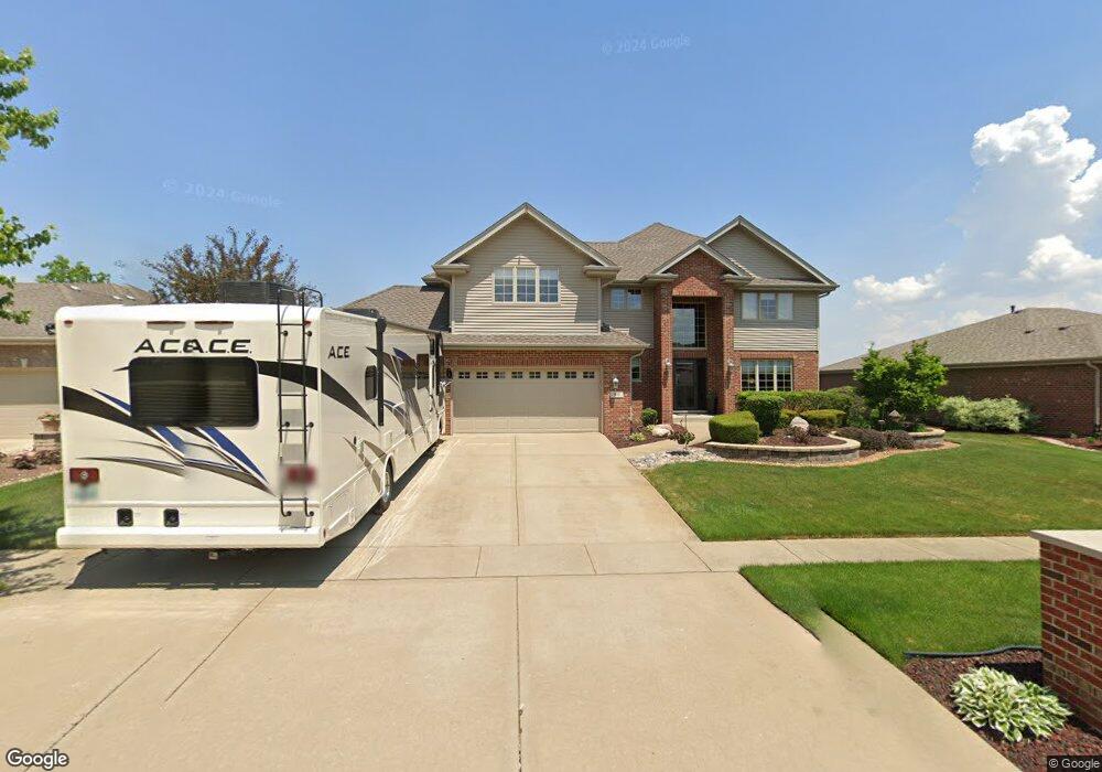
891 Krystal Ln New Lenox, IL 60451
Estimated Value: $499,809 - $589,000
--
Bed
--
Bath
--
Sq Ft
0.25
Acres
About This Home
This home is located at 891 Krystal Ln, New Lenox, IL 60451 and is currently estimated at $543,702. 891 Krystal Ln is a home located in Will County with nearby schools including Bentley Elementary School, Arnold J Tyler School, and Alex M Martino Jr High School.
Ownership History
Date
Name
Owned For
Owner Type
Purchase Details
Closed on
Apr 29, 2005
Sold by
Eagle Ridge Corp
Bought by
Knopp Olaf G and Knopp Lynn M
Current Estimated Value
Home Financials for this Owner
Home Financials are based on the most recent Mortgage that was taken out on this home.
Original Mortgage
$306,100
Outstanding Balance
$162,565
Interest Rate
6.13%
Mortgage Type
Fannie Mae Freddie Mac
Estimated Equity
$381,137
Create a Home Valuation Report for This Property
The Home Valuation Report is an in-depth analysis detailing your home's value as well as a comparison with similar homes in the area
Home Values in the Area
Average Home Value in this Area
Purchase History
| Date | Buyer | Sale Price | Title Company |
|---|---|---|---|
| Knopp Olaf G | $323,000 | -- |
Source: Public Records
Mortgage History
| Date | Status | Borrower | Loan Amount |
|---|---|---|---|
| Open | Knopp Olaf G | $306,100 |
Source: Public Records
Tax History Compared to Growth
Tax History
| Year | Tax Paid | Tax Assessment Tax Assessment Total Assessment is a certain percentage of the fair market value that is determined by local assessors to be the total taxable value of land and additions on the property. | Land | Improvement |
|---|---|---|---|---|
| 2024 | $13,027 | $168,524 | $36,393 | $132,131 |
| 2023 | $13,027 | $153,623 | $33,175 | $120,448 |
| 2022 | $11,726 | $141,523 | $30,562 | $110,961 |
| 2021 | $11,139 | $133,098 | $28,743 | $104,355 |
| 2020 | $10,826 | $128,349 | $27,717 | $100,632 |
| 2019 | $10,366 | $124,370 | $26,858 | $97,512 |
| 2018 | $10,130 | $120,083 | $25,932 | $94,151 |
| 2017 | $9,629 | $116,630 | $25,186 | $91,444 |
| 2016 | $9,350 | $113,509 | $24,512 | $88,997 |
| 2015 | $9,011 | $109,936 | $23,740 | $86,196 |
| 2014 | $9,011 | $108,579 | $23,447 | $85,132 |
| 2013 | $9,011 | $110,043 | $23,763 | $86,280 |
Source: Public Records
Map
Nearby Homes
- 513 Somerset Ln
- 449 Somerset Ln Unit 1
- 1017 E Lincoln Hwy
- 203 Tonell Ave
- 125 N Anderson Rd
- 235 Roberts Rd
- 214 Somerset Ct
- 920 Barnside Rd
- 328 E Lincoln Hwy
- 1139 Georgias Way
- 1212 Georgias Way
- 1125 Georgias Way
- 1193 Georgias Way
- 1245 Georgias Way
- 1535 Glenbrooke Ln
- 1351 E Lincoln Hwy
- 808 Stonegate Rd
- 701 Bishops Gate
- 718 S Prairie Rd
- 641 Lisson Grove
- 875 Krystal Ln
- 903 Krystal Ln
- 843 Krystal Ln
- 911 Krystal Ln
- 872 Krystal Ln Unit 5
- 856 Krystal Ln
- 886 Krystal Ln
- 840 Krystal Ln Unit 5
- 900 Krystal Ln
- 917 Krystal Ln
- 404 Krystal Ct
- 412 Krystal Ct
- 877 Cheyenne Ln Unit 3
- 893 Cheyenne Ln
- 845 Cheyenne Ln
- 906 Krystal Ln Unit 5
- 824 Krystal Ln
- 921 Krystal Ln
- 907 Cheyenne Ln
- 829 Cheyenne Ln