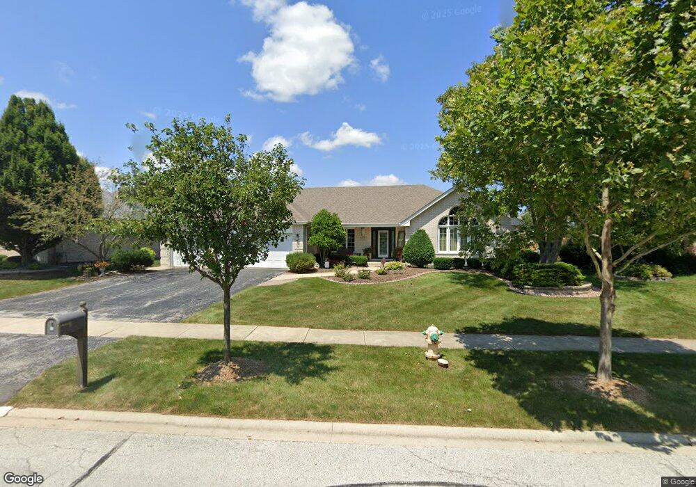
8912 Mallard Rd Tinley Park, IL 60487
Central Tinley Park NeighborhoodEstimated Value: $473,000 - $541,000
3
Beds
3
Baths
2,731
Sq Ft
$188/Sq Ft
Est. Value
About This Home
This home is located at 8912 Mallard Rd, Tinley Park, IL 60487 and is currently estimated at $514,405, approximately $188 per square foot. 8912 Mallard Rd is a home located in Cook County with nearby schools including Millennium Elementary School, Prairie View Middle School, and Victor J Andrew High School.
Ownership History
Date
Name
Owned For
Owner Type
Purchase Details
Closed on
May 15, 2025
Sold by
Martin Maureen
Bought by
Martin Family Trust and Martin
Current Estimated Value
Purchase Details
Closed on
Jan 15, 2010
Sold by
Martin Joseh M and Martin Maureen
Bought by
Martin Joseph M and Martin Maureen
Purchase Details
Closed on
May 13, 1996
Sold by
Heritage Trust Company
Bought by
Martin Joseph M and Martin Maureen
Create a Home Valuation Report for This Property
The Home Valuation Report is an in-depth analysis detailing your home's value as well as a comparison with similar homes in the area
Home Values in the Area
Average Home Value in this Area
Purchase History
| Date | Buyer | Sale Price | Title Company |
|---|---|---|---|
| Martin Family Trust | -- | None Listed On Document | |
| Martin Joseph M | -- | None Available | |
| Martin Joseph M | $242,500 | -- |
Source: Public Records
Tax History Compared to Growth
Tax History
| Year | Tax Paid | Tax Assessment Tax Assessment Total Assessment is a certain percentage of the fair market value that is determined by local assessors to be the total taxable value of land and additions on the property. | Land | Improvement |
|---|---|---|---|---|
| 2024 | $10,837 | $41,815 | $16,115 | $25,700 |
| 2023 | $11,037 | $45,000 | $16,115 | $28,885 |
| 2022 | $11,037 | $37,116 | $6,952 | $30,164 |
| 2021 | $10,738 | $37,115 | $6,951 | $30,164 |
| 2020 | $10,597 | $37,115 | $6,951 | $30,164 |
| 2019 | $10,386 | $38,198 | $6,319 | $31,879 |
| 2018 | $11,033 | $38,198 | $6,319 | $31,879 |
| 2017 | $10,757 | $38,198 | $6,319 | $31,879 |
| 2016 | $9,622 | $31,468 | $5,687 | $25,781 |
| 2015 | $9,478 | $31,468 | $5,687 | $25,781 |
| 2014 | $9,414 | $31,468 | $5,687 | $25,781 |
| 2013 | $9,481 | $34,772 | $5,687 | $29,085 |
Source: Public Records
Map
Nearby Homes
- 9038 Mansfield Dr Unit 8
- 9051 Mansfield Dr Unit 1
- 18055 Upland Dr
- 18248 Murphy Cir Unit 182
- 17964 Upland Dr
- 18261 Kirby Dr Unit 2918261
- 8423 Stratford Dr Unit 8423
- 8416 Stratford Dr Unit 8416
- 17631 Dover Ct
- 17533 Pecan Ln
- Fremont Plan at Radcliffe Place
- Calysta Plan at Radcliffe Place
- Danbury Plan at Radcliffe Place
- Briarcliffe Plan at Radcliffe Place
- Eden Plan at Radcliffe Place
- Amberwood Plan at Radcliffe Place
- 9280 Windsor Pkwy Unit 92
- 9260 Windsor Pkwy Unit 80
- 9201 175th St
- 17500 Lagrange Rd
- 8906 Mallard Rd
- 8918 Mallard Rd
- 8913 Flamingo Dr
- 8913 Mallard Rd
- 8919 Flamingo Dr
- 8900 Mallard Rd
- 8907 Flamingo Dr
- 18113 Pheasant Lake Dr
- 18107 Pheasant Lake Dr
- 8911 Mallard Rd
- 8907 Mallard Rd
- 8915 Mallard Rd
- 8917 Mallard Rd
- 8905 Mallard Rd
- 8901 Flamingo Dr
- 18101 Pheasant Lake Dr
- 8921 Mallard Rd
- 8903 Mallard Rd
- 8830 Mallard Rd
- 8923 Mallard Rd