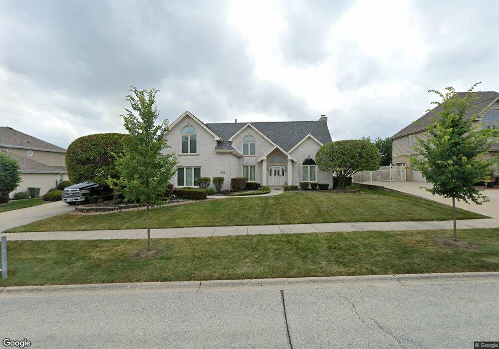
8913 Flamingo Dr Tinley Park, IL 60487
Central Tinley Park NeighborhoodEstimated Value: $543,000 - $575,000
4
Beds
3
Baths
2,870
Sq Ft
$194/Sq Ft
Est. Value
About This Home
This home is located at 8913 Flamingo Dr, Tinley Park, IL 60487 and is currently estimated at $555,795, approximately $193 per square foot. 8913 Flamingo Dr is a home located in Cook County with nearby schools including Millennium Elementary School, Prairie View Middle School, and Victor J Andrew High School.
Ownership History
Date
Name
Owned For
Owner Type
Purchase Details
Closed on
Jun 17, 1994
Sold by
Heritage Trust Company
Bought by
Roe Michael D and Roe Colleen C
Current Estimated Value
Home Financials for this Owner
Home Financials are based on the most recent Mortgage that was taken out on this home.
Original Mortgage
$150,000
Interest Rate
8.66%
Purchase Details
Closed on
Dec 21, 1993
Sold by
First United Bank
Bought by
Heritage Trust Company
Create a Home Valuation Report for This Property
The Home Valuation Report is an in-depth analysis detailing your home's value as well as a comparison with similar homes in the area
Home Values in the Area
Average Home Value in this Area
Purchase History
| Date | Buyer | Sale Price | Title Company |
|---|---|---|---|
| Roe Michael D | $303,000 | -- | |
| Heritage Trust Company | $86,666 | -- |
Source: Public Records
Mortgage History
| Date | Status | Borrower | Loan Amount |
|---|---|---|---|
| Closed | Roe Michael D | $150,000 |
Source: Public Records
Tax History Compared to Growth
Tax History
| Year | Tax Paid | Tax Assessment Tax Assessment Total Assessment is a certain percentage of the fair market value that is determined by local assessors to be the total taxable value of land and additions on the property. | Land | Improvement |
|---|---|---|---|---|
| 2024 | $11,573 | $45,000 | $17,739 | $27,261 |
| 2023 | $10,998 | $45,000 | $17,739 | $27,261 |
| 2022 | $10,998 | $34,270 | $7,652 | $26,618 |
| 2021 | $10,675 | $34,270 | $7,652 | $26,618 |
| 2020 | $10,475 | $34,270 | $7,652 | $26,618 |
| 2019 | $10,233 | $34,981 | $6,956 | $28,025 |
| 2018 | $10,012 | $34,981 | $6,956 | $28,025 |
| 2017 | $10,392 | $37,016 | $6,956 | $30,060 |
| 2016 | $9,854 | $32,167 | $6,260 | $25,907 |
| 2015 | $9,707 | $32,167 | $6,260 | $25,907 |
| 2014 | $9,642 | $32,167 | $6,260 | $25,907 |
| 2013 | $10,312 | $36,772 | $6,260 | $30,512 |
Source: Public Records
Map
Nearby Homes
- 9038 Mansfield Dr Unit 8
- 9051 Mansfield Dr Unit 1
- 18055 Upland Dr
- 18248 Murphy Cir Unit 182
- 17964 Upland Dr
- 18261 Kirby Dr Unit 2918261
- 8423 Stratford Dr Unit 8423
- 8416 Stratford Dr Unit 8416
- 17631 Dover Ct
- 17533 Pecan Ln
- Fremont Plan at Radcliffe Place
- Calysta Plan at Radcliffe Place
- Danbury Plan at Radcliffe Place
- Briarcliffe Plan at Radcliffe Place
- Eden Plan at Radcliffe Place
- Amberwood Plan at Radcliffe Place
- 9280 Windsor Pkwy Unit 92
- 9260 Windsor Pkwy Unit 80
- 9201 175th St
- 17500 Lagrange Rd
- 8907 Flamingo Dr
- 8919 Flamingo Dr
- 8912 Mallard Rd
- 8906 Mallard Rd
- 8918 Mallard Rd
- 8901 Flamingo Dr
- 18030 Cardinal Ln
- 18101 Pheasant Lake Dr
- 8900 Mallard Rd
- 18031 Cardinal Ln
- 18107 Pheasant Lake Dr
- 18031 Pheasant Lake Dr
- 18113 Pheasant Lake Dr
- 8831 Flamingo Dr
- 8830 Mallard Rd
- 8913 Mallard Rd
- 18024 Cardinal Ln
- 18030 Pelican Dr
- 18025 Cardinal Ln
- 8907 Mallard Rd