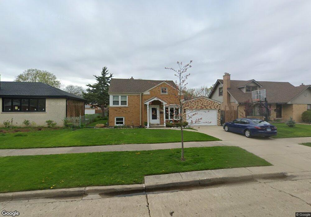
8918 Mansfield Ave Morton Grove, IL 60053
Estimated Value: $460,000 - $545,000
3
Beds
2
Baths
1,686
Sq Ft
$298/Sq Ft
Est. Value
About This Home
This home is located at 8918 Mansfield Ave, Morton Grove, IL 60053 and is currently estimated at $501,926, approximately $297 per square foot. 8918 Mansfield Ave is a home located in Cook County with nearby schools including Park View Elementary School and Niles West High School.
Ownership History
Date
Name
Owned For
Owner Type
Purchase Details
Closed on
Dec 13, 2023
Sold by
Ostrowski John S and Ostrowski Janet M
Bought by
Ostrowski Family Trust and Ostrowski
Current Estimated Value
Purchase Details
Closed on
Dec 14, 1995
Sold by
Aban Danilo D and Aban Maricel R
Bought by
Ostrowski John S and Ostrowski Janet M
Home Financials for this Owner
Home Financials are based on the most recent Mortgage that was taken out on this home.
Original Mortgage
$121,000
Interest Rate
7.45%
Create a Home Valuation Report for This Property
The Home Valuation Report is an in-depth analysis detailing your home's value as well as a comparison with similar homes in the area
Home Values in the Area
Average Home Value in this Area
Purchase History
| Date | Buyer | Sale Price | Title Company |
|---|---|---|---|
| Ostrowski Family Trust | -- | None Listed On Document | |
| Ostrowski John S | $228,000 | -- |
Source: Public Records
Mortgage History
| Date | Status | Borrower | Loan Amount |
|---|---|---|---|
| Previous Owner | Ostrowski John S | $121,000 |
Source: Public Records
Tax History Compared to Growth
Tax History
| Year | Tax Paid | Tax Assessment Tax Assessment Total Assessment is a certain percentage of the fair market value that is determined by local assessors to be the total taxable value of land and additions on the property. | Land | Improvement |
|---|---|---|---|---|
| 2024 | $4,681 | $19,190 | $4,875 | $14,315 |
| 2023 | $4,434 | $19,190 | $4,875 | $14,315 |
| 2022 | $4,434 | $19,190 | $4,875 | $14,315 |
| 2021 | $3,738 | $13,320 | $3,000 | $10,320 |
| 2020 | $3,674 | $13,320 | $3,000 | $10,320 |
| 2019 | $3,711 | $14,967 | $3,000 | $11,967 |
| 2018 | $4,499 | $15,976 | $2,718 | $13,258 |
| 2017 | $4,542 | $15,976 | $2,718 | $13,258 |
| 2016 | $4,413 | $15,976 | $2,718 | $13,258 |
| 2015 | $4,069 | $13,937 | $2,343 | $11,594 |
| 2014 | $4,073 | $13,937 | $2,343 | $11,594 |
| 2013 | $3,970 | $13,937 | $2,343 | $11,594 |
Source: Public Records
Map
Nearby Homes
- 8836 Mansfield Ave
- 8841 Menard Ave
- 8849 Mcvicker Ave
- 8918 Parkside Ave
- 5536 Greenwood St
- 9224 Menard Ave
- 8708 Central Ave
- 5459 Suffield Ct
- 9314 Menard Ave
- 9320 Menard Ave
- 9234 Central Ave
- 5449 Arcadia St
- 5644 Lyons St
- 6020 Lincoln Ave Unit 407
- 5352 Greenwood St
- 8655 Harms Rd
- 6035 Lincoln Ave
- 5346 Suffield Terrace
- 6330 Hennings Ct
- 6332 Hennings Ct
- 8918 Mansfield Ave
- 8912 Mansfield Ave
- 8920 Mansfield Ave
- 8920 Mansfield Ave
- 8910 Mansfield Ave
- 8928 Mansfield Ave
- 8906 Mansfield Ave
- 8917 Marmora Ave
- 8919 Marmora Ave
- 8913 Marmora Ave
- 8923 Marmora Ave
- 8930 Mansfield Ave
- 8909 Marmora Ave
- 8927 Marmora Ave
- 8917 Mansfield Ave
- 8902 Mansfield Ave
- 8925 Mansfield Ave
- 8905 Marmora Ave
- 8913 Mansfield Ave
- 8913 Mansfield Ave