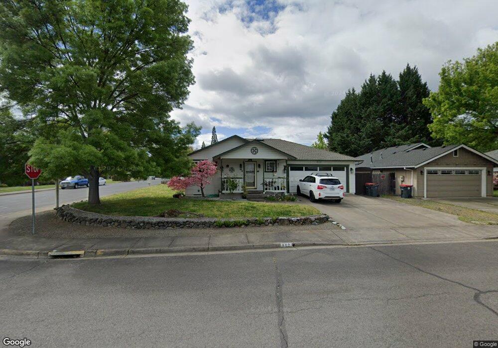
892 Westrop Dr Central Point, OR 97502
Estimated Value: $393,000 - $412,000
3
Beds
2
Baths
1,550
Sq Ft
$261/Sq Ft
Est. Value
About This Home
This home is located at 892 Westrop Dr, Central Point, OR 97502 and is currently estimated at $404,089, approximately $260 per square foot. 892 Westrop Dr is a home located in Jackson County with nearby schools including Howard Elementary School, McLoughlin Middle School, and North Medford High School.
Ownership History
Date
Name
Owned For
Owner Type
Purchase Details
Closed on
Oct 6, 1999
Sold by
Smith Christopher F and Smith Paula K
Bought by
Kirk Jan M
Current Estimated Value
Home Financials for this Owner
Home Financials are based on the most recent Mortgage that was taken out on this home.
Original Mortgage
$100,000
Outstanding Balance
$27,921
Interest Rate
7.76%
Estimated Equity
$376,168
Create a Home Valuation Report for This Property
The Home Valuation Report is an in-depth analysis detailing your home's value as well as a comparison with similar homes in the area
Purchase History
| Date | Buyer | Sale Price | Title Company |
|---|---|---|---|
| Kirk Jan M | $127,000 | Amerititle |
Source: Public Records
Mortgage History
| Date | Status | Borrower | Loan Amount |
|---|---|---|---|
| Open | Kirk Jan M | $100,000 |
Source: Public Records
Tax History
| Year | Tax Paid | Tax Assessment Tax Assessment Total Assessment is a certain percentage of the fair market value that is determined by local assessors to be the total taxable value of land and additions on the property. | Land | Improvement |
|---|---|---|---|---|
| 2026 | $3,949 | $237,730 | -- | -- |
| 2025 | $3,861 | $230,810 | $74,850 | $155,960 |
| 2024 | $3,861 | $224,090 | $72,670 | $151,420 |
| 2023 | $3,744 | $217,570 | $70,560 | $147,010 |
| 2022 | $3,650 | $217,570 | $70,560 | $147,010 |
| 2021 | $3,554 | $211,240 | $68,500 | $142,740 |
| 2020 | $3,465 | $205,090 | $66,500 | $138,590 |
| 2019 | $3,380 | $193,330 | $62,680 | $130,650 |
| 2018 | $3,292 | $187,700 | $60,860 | $126,840 |
| 2017 | $3,227 | $187,700 | $60,860 | $126,840 |
| 2016 | $3,158 | $176,940 | $57,360 | $119,580 |
| 2015 | $3,035 | $176,940 | $57,360 | $119,580 |
| 2014 | $2,979 | $166,790 | $54,060 | $112,730 |
Source: Public Records
Map
Nearby Homes
- 959 Westrop Dr
- 1258 Joshua Ct
- 1204 Heather Ln
- 3358 Bursell Rd
- 659 Herman Ave
- 3364 Bursell Rd
- 14 Scholarship Way
- 18 Scholarship Way
- 1065 Edwina Ave
- 105 Queens Gate Ct
- 2841 Howard Ave
- 1025 Fairfield Ave
- 736 Hemlock Ave
- 2825 Howard Ave
- 3600 N Pacific Hwy
- 2817 Howard Ave
- 2727 Connell Ave
- 918 Brandi Way
- 2717 Elliott Ave
- 171 Mellecker Way
- 890 Westrop Dr
- 1321 Marilee St
- 948 Westrop Dr
- 886 Westrop Dr
- 1341 Marilee St
- 899 Westrop Dr
- 891 Westrop Dr
- 1308 Magruder Ct
- 882 Westrop Dr
- 952 Westrop Dr
- 951 Westrop Dr
- 885 Westrop Dr
- 1361 Marilee St
- 1310 Magruder Ct
- 654 Marlin Way
- 953 Westrop Dr
- 1312 Magruder Ct
- 958 Westrop Dr
- 892 Isaac Way
- 1381 Marilee St
Your Personal Tour Guide
Ask me questions while you tour the home.