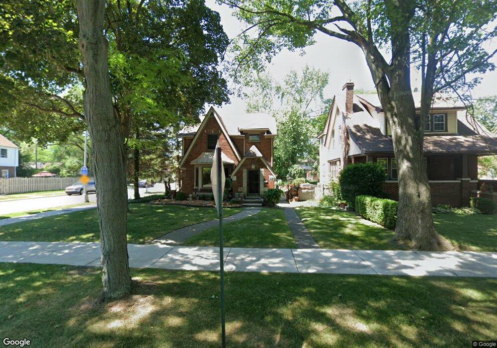
893 Fisher Rd Grosse Pointe, MI 48230
Estimated Value: $383,971 - $481,000
--
Bed
--
Bath
1,637
Sq Ft
$265/Sq Ft
Est. Value
About This Home
This home is located at 893 Fisher Rd, Grosse Pointe, MI 48230 and is currently estimated at $434,493, approximately $265 per square foot. 893 Fisher Rd is a home located in Wayne County with nearby schools including Richard Elementary School, Brownell Middle School, and Grosse Pointe South High School.
Ownership History
Date
Name
Owned For
Owner Type
Purchase Details
Closed on
Aug 20, 2003
Sold by
Murphy Halet and Murphy Samantha
Bought by
Nixon John H
Current Estimated Value
Purchase Details
Closed on
Dec 15, 1999
Sold by
Louchart Lisa P
Bought by
Murphy Samantha
Purchase Details
Closed on
Nov 27, 1996
Sold by
Taylor David L and Taylor Laura Z
Bought by
Lisa P Louchart
Purchase Details
Closed on
May 15, 1995
Sold by
Claude H Miller
Bought by
Taylor David L and Taylor Laura Z
Create a Home Valuation Report for This Property
The Home Valuation Report is an in-depth analysis detailing your home's value as well as a comparison with similar homes in the area
Home Values in the Area
Average Home Value in this Area
Purchase History
| Date | Buyer | Sale Price | Title Company |
|---|---|---|---|
| Nixon John H | $290,000 | Heritage Title Company | |
| Murphy Samantha | $248,000 | -- | |
| Lisa P Louchart | $166,000 | -- | |
| Taylor David L | $151,400 | -- |
Source: Public Records
Tax History Compared to Growth
Tax History
| Year | Tax Paid | Tax Assessment Tax Assessment Total Assessment is a certain percentage of the fair market value that is determined by local assessors to be the total taxable value of land and additions on the property. | Land | Improvement |
|---|---|---|---|---|
| 2025 | $3,982 | $194,900 | $0 | $0 |
| 2024 | $3,982 | $186,300 | $0 | $0 |
| 2023 | $3,798 | $171,100 | $0 | $0 |
| 2022 | $5,497 | $153,000 | $0 | $0 |
| 2021 | $5,212 | $146,100 | $0 | $0 |
| 2019 | $5,413 | $139,700 | $0 | $0 |
| 2018 | $3,296 | $126,600 | $0 | $0 |
| 2017 | $3,480 | $125,100 | $0 | $0 |
| 2016 | $4,961 | $122,400 | $0 | $0 |
| 2015 | $9,408 | $104,700 | $0 | $0 |
| 2013 | $9,114 | $97,400 | $0 | $0 |
| 2012 | -- | $89,000 | $0 | $0 |
Source: Public Records
Map
Nearby Homes
- 827 Fisher Rd
- 876 Washington Rd
- 352 Mckinley Ave
- 975 Fisher Rd
- 341 Mcmillan Rd
- 380 Merriweather Rd
- 343 Mount Vernon Ave
- 415 Lothrop Rd
- 317 Mount Vernon Ave
- 314 Mount Vernon Ave
- 872 University Place
- 276 Lewiston Rd
- 745 Lincoln Rd
- 302 Mount Vernon Ave
- 441 Manor St
- 4598 Lodewyck St
- 4607 Radnor St
- 259 Mount Vernon Ave
- 18119 Cornwall St
- 194 Charlevoix Ave