Estimated Value: $150,000 - $212,640
3
Beds
2
Baths
1,723
Sq Ft
$101/Sq Ft
Est. Value
About This Home
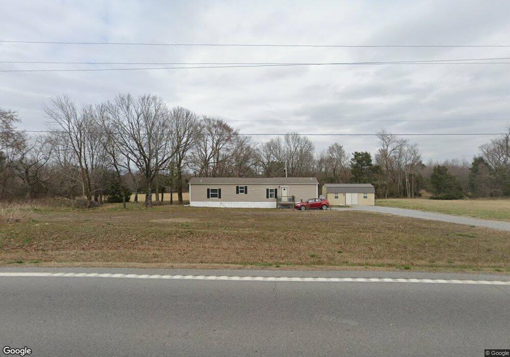
This home is located at 8930 White Dr, Cord, AR 72524 and is currently estimated at $173,660, approximately $100 per square foot. 8930 White Dr is a home located in Independence County with nearby schools including Cord-Charlotte Elementary School and Cedar Ridge High School.
Ownership History
Date
Name
Owned For
Owner Type
Purchase Details
Closed on
Jun 5, 2009
Bought by
Branscum Roy
Current Estimated Value
Purchase Details
Closed on
Dec 14, 2007
Sold by
Branscum Kathleen J
Bought by
Branscum Russell D
Purchase Details
Closed on
Oct 19, 2007
Sold by
Branscum Kathleen J
Bought by
Branscum Russell D
Purchase Details
Closed on
Aug 8, 2006
Sold by
Branscum Lisa N
Bought by
Branscum Russell D
Purchase Details
Closed on
Dec 7, 2002
Sold by
Not Provided
Bought by
Branscum Russell D
Purchase Details
Closed on
Dec 6, 2002
Sold by
Not Provided
Bought by
Huskey Nita Walden
Purchase Details
Closed on
May 2, 2001
Bought by
Walden Thomas J and Nita Walden Huskey %
Purchase Details
Closed on
Jan 1, 1982
Bought by
Walden Thomas J and Nita Walden Huskey %
Create a Home Valuation Report for This Property
The Home Valuation Report is an in-depth analysis detailing your home's value as well as a comparison with similar homes in the area
Home Values in the Area
Average Home Value in this Area
Purchase History
| Date | Buyer | Sale Price | Title Company |
|---|---|---|---|
| Branscum Roy | $79,000 | -- | |
| Branscum Roy | $79,000 | -- | |
| Branscum Russell D | -- | -- | |
| Branscum Russell D | -- | -- | |
| Branscum Russell D | $80,000 | -- | |
| Branscum Russell D | $80,000 | -- | |
| Branscum Russell D | -- | -- | |
| Branscum Roy L | -- | -- | |
| Branscum Russell D | $110,000 | -- | |
| Branscum Roy L | $110,000 | -- | |
| Huskey Nita Walden | -- | -- | |
| Huskey Nita Walden | -- | -- | |
| Walden Thomas J | -- | -- | |
| Walden Thomas J | $3,000 | -- |
Source: Public Records
Tax History Compared to Growth
Tax History
| Year | Tax Paid | Tax Assessment Tax Assessment Total Assessment is a certain percentage of the fair market value that is determined by local assessors to be the total taxable value of land and additions on the property. | Land | Improvement |
|---|---|---|---|---|
| 2024 | $464 | $19,040 | $2,390 | $16,650 |
| 2023 | $539 | $19,040 | $2,390 | $16,650 |
| 2022 | $589 | $19,040 | $2,390 | $16,650 |
| 2021 | $589 | $19,040 | $2,390 | $16,650 |
| 2020 | $589 | $19,040 | $2,390 | $16,650 |
| 2019 | $516 | $18,860 | $2,570 | $16,290 |
| 2018 | $541 | $18,860 | $2,570 | $16,290 |
| 2017 | $533 | $18,860 | $2,570 | $16,290 |
| 2016 | $541 | $18,860 | $2,570 | $16,290 |
| 2015 | $533 | $18,860 | $2,570 | $16,290 |
| 2014 | $500 | $18,170 | $2,350 | $15,820 |
Source: Public Records
Map
Nearby Homes
- 105 Walden Rd
- 701 Wpa Rd
- 250 Summerset Ln
- 400 Weaver Ln
- 6118 Cord Rd
- 14 Law 351
- 5976 and 5980 Cord Rd Rd
- 15 Hawks Run
- 1962 acres Upper Lockhart Rd
- 1962 Upper Lockhart Rd
- 70 and 76 Crow Ln
- 1700 Sanders Rd
- 6820 White Dr
- 183 Law 352 Strawberry
- 310 Lawrence Road 333
- 201 Cr-319
- 195 Cee Jay Ln
- 00 Kirby Ln
- 1800 Antioch Rd
- 56 Law 338