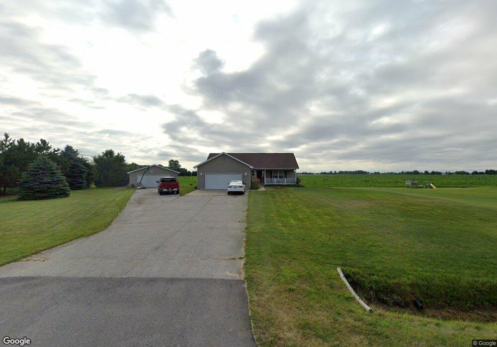
8938 Hospital Rd Freeland, MI 48623
Estimated Value: $279,000 - $435,000
3
Beds
2
Baths
1,472
Sq Ft
$229/Sq Ft
Est. Value
About This Home
This home is located at 8938 Hospital Rd, Freeland, MI 48623 and is currently estimated at $336,836, approximately $228 per square foot. 8938 Hospital Rd is a home located in Bay County with nearby schools including Freeland Learning Center, Freeland Elementary School, and Freeland Middle/High School.
Ownership History
Date
Name
Owned For
Owner Type
Purchase Details
Closed on
Oct 16, 2019
Sold by
King Gregory and King Linda
Bought by
King Gregory and King Linda
Current Estimated Value
Home Financials for this Owner
Home Financials are based on the most recent Mortgage that was taken out on this home.
Original Mortgage
$57,700
Outstanding Balance
$50,171
Interest Rate
3.6%
Mortgage Type
New Conventional
Estimated Equity
$286,665
Purchase Details
Closed on
Jun 21, 2001
Sold by
Helmreich David and Helmreich Joyce
Bought by
King Gregory and King Linda
Create a Home Valuation Report for This Property
The Home Valuation Report is an in-depth analysis detailing your home's value as well as a comparison with similar homes in the area
Home Values in the Area
Average Home Value in this Area
Purchase History
| Date | Buyer | Sale Price | Title Company |
|---|---|---|---|
| King Gregory | -- | None Available | |
| King Gregory | $14,000 | -- |
Source: Public Records
Mortgage History
| Date | Status | Borrower | Loan Amount |
|---|---|---|---|
| Open | King Gregory | $57,700 |
Source: Public Records
Tax History Compared to Growth
Tax History
| Year | Tax Paid | Tax Assessment Tax Assessment Total Assessment is a certain percentage of the fair market value that is determined by local assessors to be the total taxable value of land and additions on the property. | Land | Improvement |
|---|---|---|---|---|
| 2025 | $2,731 | $151,550 | $0 | $0 |
| 2024 | $889 | $131,000 | $0 | $0 |
| 2023 | $847 | $124,850 | $0 | $0 |
| 2022 | $2,469 | $101,050 | $0 | $0 |
| 2021 | $2,178 | $91,850 | $91,850 | $0 |
| 2020 | $2,159 | $94,400 | $94,400 | $0 |
| 2019 | $1,990 | $87,750 | $0 | $0 |
| 2018 | $1,937 | $81,450 | $0 | $0 |
| 2017 | $1,797 | $77,700 | $0 | $0 |
| 2016 | $1,801 | $86,950 | $0 | $86,950 |
| 2015 | $1,807 | $60,750 | $0 | $60,750 |
| 2014 | $1,807 | $58,100 | $0 | $58,100 |
Source: Public Records
Map
Nearby Homes
- 9325 Hospital Rd
- 6641 Pierce Rd
- 6790 Hospital Rd
- 4079 S 8 Mile Rd
- 9924 Garner Ln
- 7474 Kochville Rd
- 9100 Brook Hollow Ln
- 9160 Brook Hollow Ln
- 8421 Waxwing Dr
- 10123 Hawk Dr
- 1040 Wheelock St
- 8599 Ashland Place
- 8535 Summer Ridge Dr
- 8442 Cottonwood Dr
- 0000 Pierce Rd
- 10585 Prairie View Ct
- 10399 Webster Rd
- 0 Foxtail Trail Unit 50182332
- 8630 Foxtail Trail
- 8657 Foxtail Trail
- 8950 Hospital Rd
- 8850 Hospital Rd
- 8990 Hospital Rd
- 8895 Hospital Rd
- 8810 Hospital Rd
- 8957 Hospital Rd
- 8787 Hospital Rd
- 8995 Hospital Rd
- 0 Amelith Rd
- 8768 Hospital Rd
- 7055 Sarle Rd
- 8769 Hospital Rd
- 8739 Hospital Rd
- 7109 Sarle Rd
- 25 Amelith Rd
- 8726 Hospital Rd
- 8700 Hospital Rd
- 7145 Sarle Rd
- 130 Amelith Rd
- 9089 Hospital Rd