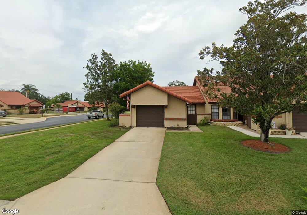
895 Tetlow Ct NE Palm Bay, FL 32905
Port Malabar NeighborhoodEstimated Value: $188,396 - $224,000
2
Beds
2
Baths
888
Sq Ft
$232/Sq Ft
Est. Value
About This Home
This home is located at 895 Tetlow Ct NE, Palm Bay, FL 32905 and is currently estimated at $206,349, approximately $232 per square foot. 895 Tetlow Ct NE is a home located in Brevard County with nearby schools including Riviera Elementary School, Stone Magnet Middle School, and Palm Bay Magnet Senior High School.
Ownership History
Date
Name
Owned For
Owner Type
Purchase Details
Closed on
Jan 25, 2019
Sold by
Latino Wayne and Latino Claire M
Bought by
Latino Claire M
Current Estimated Value
Purchase Details
Closed on
Feb 28, 2014
Sold by
Latino Charles W and Latino Peter R
Bought by
Latino C Wayne and Latino Claire M
Purchase Details
Closed on
Dec 30, 2002
Sold by
Latino Charles D and Latino Shirley P
Bought by
Latino Charles W and Latino Peter R
Create a Home Valuation Report for This Property
The Home Valuation Report is an in-depth analysis detailing your home's value as well as a comparison with similar homes in the area
Home Values in the Area
Average Home Value in this Area
Purchase History
| Date | Buyer | Sale Price | Title Company |
|---|---|---|---|
| Latino Claire M | $10,000 | None Available | |
| Latino C Wayne | $70,000 | Supreme Title Closings Llc | |
| Latino Charles W | -- | -- |
Source: Public Records
Tax History Compared to Growth
Tax History
| Year | Tax Paid | Tax Assessment Tax Assessment Total Assessment is a certain percentage of the fair market value that is determined by local assessors to be the total taxable value of land and additions on the property. | Land | Improvement |
|---|---|---|---|---|
| 2025 | $2,400 | $172,650 | -- | -- |
| 2024 | $2,383 | $167,790 | -- | -- |
| 2023 | $2,383 | $165,320 | $0 | $0 |
| 2022 | $2,287 | $160,510 | $0 | $0 |
| 2021 | $2,284 | $112,210 | $31,500 | $80,710 |
| 2020 | $2,086 | $103,570 | $26,250 | $77,320 |
| 2019 | $2,057 | $90,890 | $21,000 | $69,890 |
| 2018 | $1,865 | $86,410 | $21,000 | $65,410 |
| 2017 | $1,751 | $75,820 | $15,750 | $60,070 |
| 2016 | $1,508 | $66,080 | $10,500 | $55,580 |
| 2015 | $1,434 | $60,940 | $15,750 | $45,190 |
| 2014 | $1,372 | $56,970 | $15,750 | $41,220 |
Source: Public Records
Map
Nearby Homes
- 1647 Avery Rd NE
- 1698 Sunny Brook Ln NE Unit G203
- 1698 Sunny Brook Ln NE Unit 206
- 1825 Market Cir NE
- 1680 Sunny Brook Ln NE Unit 103
- 1600 Sunny Brook Ln NE Unit F108
- 1460 Par St NE
- 815 Brae Ct NE
- 609 Cedar Side Cir NE
- 1640 Sunny Brook Ln NE Unit A203
- 1573 Par St NE
- 950 Hooper Ave NE
- 1624 Sunny Brook Ln NE Unit 203
- 1617 Sunny Brook Ln NE Unit F103
- 1609 Sunny Brook Ln NE Unit 102
- 790 Aragon Ave NE
- 840 Hawks Ridge Ct NE
- 3612 Tree Ridge Ln NE
- 725 Port Malabar Blvd NE Unit 106
- 725 Port Malabar Blvd NE Unit 104
- 865 Tetlow Ct NE
- 835 Tetlow Ct NE
- 805 Tetlow Ct NE
- 1686 Avery Rd NE
- 1688 Avery Rd NE
- 1683 Avery Rd NE
- 894 Tetlow Ct NE
- 864 Tetlow Ct NE
- 1687 Avery Rd NE
- 1679 Avery Rd NE
- 834 Tetlow Ct NE
- 1691 Avery Rd NE
- 1675 Avery Rd NE
- 1690 Avery Rd NE
- 1671 Avery Rd NE
- 804 Tetlow Ct NE
- 1692 Avery Rd NE
- 1665 Avery Rd NE
- 1665 Avery Rd NE Unit 5
- 1694 Avery Rd NE