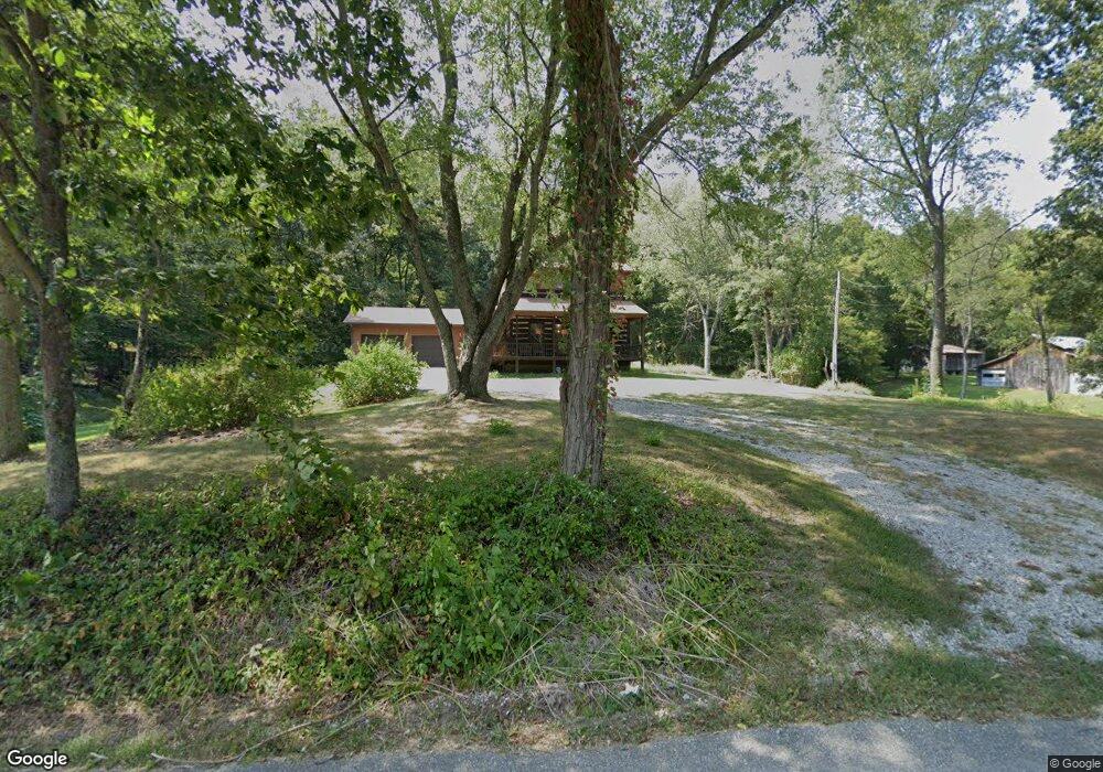
8956 Houston Rd Freetown, IN 47235
Estimated Value: $378,000 - $777,030
2
Beds
2
Baths
1,632
Sq Ft
$348/Sq Ft
Est. Value
About This Home
This home is located at 8956 Houston Rd, Freetown, IN 47235 and is currently estimated at $568,343, approximately $348 per square foot. 8956 Houston Rd is a home located in Brown County with nearby schools including Brown County High School.
Ownership History
Date
Name
Owned For
Owner Type
Purchase Details
Closed on
Apr 17, 2025
Sold by
Revocable Trust Agreement Of Bob D Wilso and Wilson Clark
Bought by
Wilson Clark
Current Estimated Value
Purchase Details
Closed on
Apr 10, 2025
Sold by
Wilson Clark
Bought by
Wilson Family Living Trust
Purchase Details
Closed on
Oct 29, 2014
Sold by
Wilson Bob D
Bought by
Wilson Bob D and Bob D Wilson Revocable Trust Agreement
Create a Home Valuation Report for This Property
The Home Valuation Report is an in-depth analysis detailing your home's value as well as a comparison with similar homes in the area
Home Values in the Area
Average Home Value in this Area
Purchase History
| Date | Buyer | Sale Price | Title Company |
|---|---|---|---|
| Wilson Clark | $360,000 | None Listed On Document | |
| Wilson Family Living Trust | -- | None Listed On Document | |
| Wilson Bob D | -- | None Available |
Source: Public Records
Tax History Compared to Growth
Tax History
| Year | Tax Paid | Tax Assessment Tax Assessment Total Assessment is a certain percentage of the fair market value that is determined by local assessors to be the total taxable value of land and additions on the property. | Land | Improvement |
|---|---|---|---|---|
| 2024 | $4,069 | $622,600 | $421,300 | $201,300 |
| 2023 | $3,611 | $530,600 | $343,800 | $186,800 |
| 2022 | $3,617 | $486,600 | $337,600 | $149,000 |
| 2021 | $3,817 | $462,100 | $337,600 | $124,500 |
| 2020 | $3,833 | $450,800 | $328,200 | $122,600 |
| 2019 | $3,711 | $444,200 | $328,200 | $116,000 |
| 2018 | $4,281 | $442,500 | $328,200 | $114,300 |
| 2017 | $4,282 | $434,000 | $328,200 | $105,800 |
| 2016 | $4,094 | $429,900 | $328,200 | $101,700 |
| 2014 | $3,525 | $417,900 | $328,200 | $89,700 |
| 2013 | $3,525 | $416,000 | $328,200 | $87,800 |
Source: Public Records
Map
Nearby Homes
- 8650 Mount Nebo Rd
- 9601 Buffalo Pike
- 7693 S Bob Allen Rd
- 7275 Hamilton Creek Rd
- 11000 N County Road 650 W
- 7932 S Mount Nebo Rd
- XXXX Keith Donaldson Rd
- 6913 Poplar Grove Rd
- 6985 Poplar Grove Rd
- 2000 Block W 1125 N
- 7594 W County Road 925 N
- 9649 N County Road 450 W
- 00 Lutheran Lake Rd
- 6947 Poplar Grove Rd
- 6873 Poplar Grove Rd
- 5217 Bellsville Pike
- 4410 State Rd 135
- 3000 W Block Co Rd 900 N
- 14000 W Lake Rd
- 3978 State Road 135 S
- 9005 Houston Rd
- 8662 Houston Rd
- 9188 Houston Rd
- 8540 Houston Rd
- 9411 Houston Rd
- 8160 State Road 135 S
- 8375 State Road 135 S
- 8526 State Road 135 S
- 8803 State Road 135
- 9278 Houston Rd
- 8564 State Road 135 S
- 8171 State Road 135 S
- 8181 State Road 135 S
- 8181 State Road 135 S
- 8084 State Road 135
- 8084 State Road 135 S
- 8084 Indiana 135
- 8573 State Road 135 S
- 8569 State Road 135 S
- 9444 Houston Rd