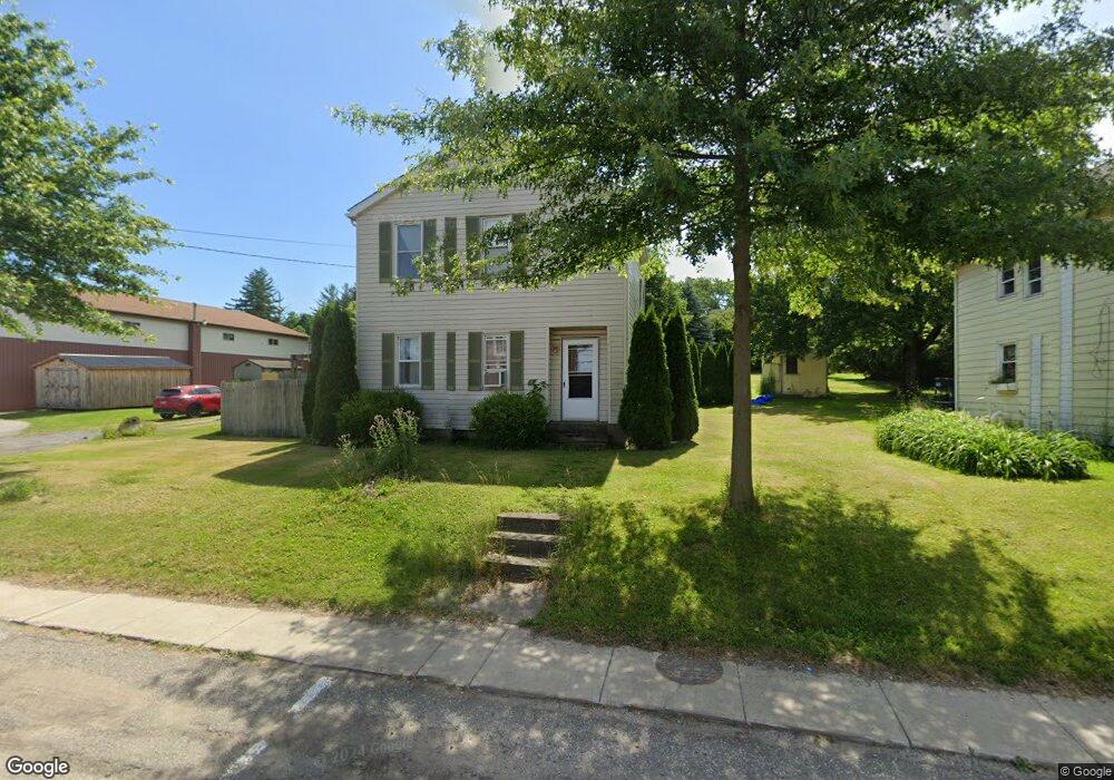
8961 Main St Mc Kean, PA 16426
Estimated Value: $163,000 - $317,000
3
Beds
2
Baths
1,474
Sq Ft
$155/Sq Ft
Est. Value
About This Home
This home is located at 8961 Main St, Mc Kean, PA 16426 and is currently estimated at $228,268, approximately $154 per square foot. 8961 Main St is a home located in Erie County with nearby schools including McKean Elementary School, James W. Parker Middle School, and General McLane High School.
Ownership History
Date
Name
Owned For
Owner Type
Purchase Details
Closed on
Oct 19, 2000
Sold by
Matts Helen and Matts Kenneth R
Bought by
Dobrzynski Peter J and Dobrzynski Cathy L
Current Estimated Value
Home Financials for this Owner
Home Financials are based on the most recent Mortgage that was taken out on this home.
Original Mortgage
$58,500
Outstanding Balance
$21,197
Interest Rate
7.83%
Estimated Equity
$207,071
Create a Home Valuation Report for This Property
The Home Valuation Report is an in-depth analysis detailing your home's value as well as a comparison with similar homes in the area
Home Values in the Area
Average Home Value in this Area
Purchase History
| Date | Buyer | Sale Price | Title Company |
|---|---|---|---|
| Dobrzynski Peter J | $65,000 | -- |
Source: Public Records
Mortgage History
| Date | Status | Borrower | Loan Amount |
|---|---|---|---|
| Open | Dobrzynski Peter J | $58,500 |
Source: Public Records
Tax History Compared to Growth
Tax History
| Year | Tax Paid | Tax Assessment Tax Assessment Total Assessment is a certain percentage of the fair market value that is determined by local assessors to be the total taxable value of land and additions on the property. | Land | Improvement |
|---|---|---|---|---|
| 2025 | $1,898 | $83,390 | $28,700 | $54,690 |
| 2024 | $1,838 | $83,390 | $28,700 | $54,690 |
| 2023 | $1,730 | $83,390 | $28,700 | $54,690 |
| 2022 | $1,679 | $83,390 | $28,700 | $54,690 |
| 2021 | $1,658 | $83,390 | $28,700 | $54,690 |
| 2020 | $1,637 | $83,390 | $28,700 | $54,690 |
| 2019 | $86 | $83,390 | $28,700 | $54,690 |
| 2018 | $1,591 | $83,390 | $28,700 | $54,690 |
| 2017 | $1,591 | $83,390 | $28,700 | $54,690 |
| 2016 | $1,828 | $83,390 | $28,700 | $54,690 |
| 2015 | $1,807 | $83,390 | $28,700 | $54,690 |
| 2014 | $901 | $83,390 | $28,700 | $54,690 |
Source: Public Records
Map
Nearby Homes
- 0 Edinboro Rd Unit 183772
- 0 Edinboro Rd Unit 182375
- 0 Edinboro Rd Unit 173270
- 11897 Silverthorn (Tr 86 Rt T438) Rd
- 5115 West Rd
- 4817 Greenlee Rd
- 702 Skyline Dr
- 127 Timberlake Dr
- 4241 Dunn Valley Rd
- 9735 Old Route 99
- 8580 Rick Rd
- 29 Sharon Dr
- 7761 Grubb Rd
- 10050 Old Route 99
- 5233 California Rd
- 0 S Hill Rd
- 0 Flower Rd
- 8720 Oriole Dr
- 6419 Sterrettania Rd
- 8675 Oriole Dr
- 8967 Main St
- 8971 Main St
- 8962 Main St Unit 64
- 8962 Main St
- 8975 Main St
- 0 Edinboro Rd Unit 174303
- 0 Edinboro Rd Unit 168165
- 0 Edinboro Rd Unit 166097
- 0 Edinboro Rd Unit 1577969
- 0 Edinboro Rd Unit 165646
- 0 Edinboro Rd Unit 165020
- 0 Edinboro Rd Unit A Road 163559
- 0 Edinboro Rd
- 5022 East Ave
- 4953 School St
- 8974 Main St
- 5010 East Ave
- 5045 N Main St
- 9007 Main St Unit 2
- 9005 Main St Unit 5