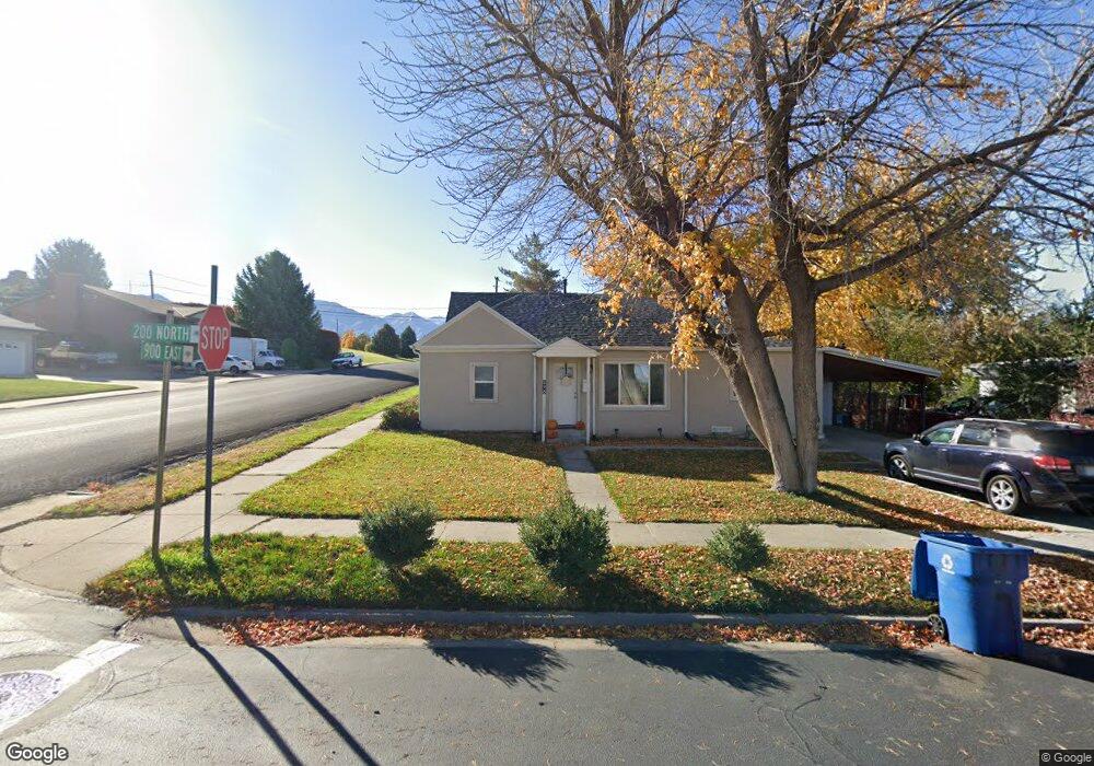
898 E 200 N Spanish Fork, UT 84660
Estimated Value: $355,206 - $398,000
3
Beds
1
Bath
1,352
Sq Ft
$280/Sq Ft
Est. Value
About This Home
This home is located at 898 E 200 N, Spanish Fork, UT 84660 and is currently estimated at $378,402, approximately $279 per square foot. 898 E 200 N is a home with nearby schools including Park Elementary School, Spanish Fork Jr High School, and Spanish Fork High School.
Ownership History
Date
Name
Owned For
Owner Type
Purchase Details
Closed on
Feb 28, 2022
Sold by
Scott Roberts
Bought by
Viking Investing Llc
Current Estimated Value
Purchase Details
Closed on
Jul 11, 2018
Sold by
Roberts La Mar Kay
Bought by
Roberts Scott and Roberts Janessa
Purchase Details
Closed on
Aug 31, 2008
Sold by
Roberts Lela Kaye
Bought by
Roberts La Mar Kay
Create a Home Valuation Report for This Property
The Home Valuation Report is an in-depth analysis detailing your home's value as well as a comparison with similar homes in the area
Home Values in the Area
Average Home Value in this Area
Purchase History
| Date | Buyer | Sale Price | Title Company |
|---|---|---|---|
| Viking Investing Llc | -- | None Listed On Document | |
| Roberts Scott | -- | Provo Land Title Co | |
| Roberts La Mar Kay | -- | None Available |
Source: Public Records
Tax History
| Year | Tax Paid | Tax Assessment Tax Assessment Total Assessment is a certain percentage of the fair market value that is determined by local assessors to be the total taxable value of land and additions on the property. | Land | Improvement |
|---|---|---|---|---|
| 2025 | $1,526 | $172,040 | -- | -- |
| 2024 | $1,526 | $157,245 | $0 | $0 |
| 2023 | $1,555 | $160,490 | $0 | $0 |
| 2022 | $1,542 | $156,035 | $0 | $0 |
| 2021 | $1,328 | $215,000 | $79,100 | $135,900 |
| 2020 | $1,196 | $188,300 | $65,900 | $122,400 |
| 2019 | $1,040 | $172,300 | $65,900 | $106,400 |
| 2018 | $990 | $158,400 | $65,900 | $92,500 |
| 2017 | $941 | $80,960 | $0 | $0 |
| 2016 | $777 | $65,945 | $0 | $0 |
| 2015 | $705 | $59,125 | $0 | $0 |
| 2014 | $655 | $55,165 | $0 | $0 |
Source: Public Records
Map
Nearby Homes
- 284 N 1000 E
- 265 N 800 E
- 306 N 1070 E
- 306 N 1070 E Unit 17
- 274 N 1070 E Unit 14
- 299 N 1070 E Unit 8
- 212 N 1070 E Unit 9
- 314 N 1070 E
- 998 E 260 N Unit 16
- 992 E 260 N Unit 15
- 973 E 60 S
- 136 N 1120 E
- 679 E 400 N
- 453 N 1210 E
- 1025 E 360 N Unit 5
- 1022 E 360 N Unit 27
- 991 E 360 N Unit 8
- 270 N 500 E
- 1238 E 100 S
- 1074 E 660 N
Your Personal Tour Guide
Ask me questions while you tour the home.