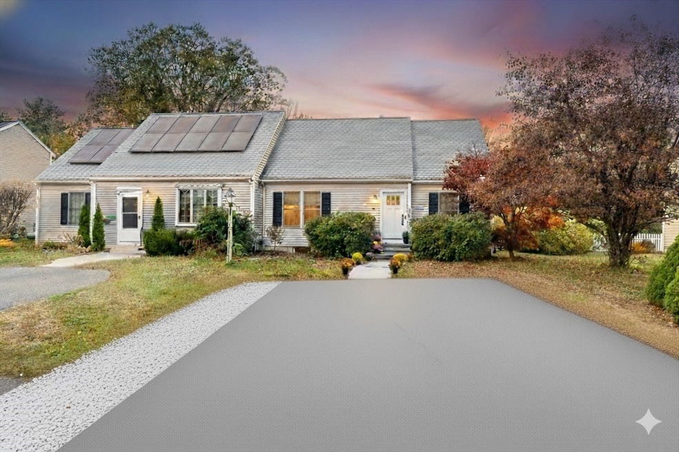


9 Andrews Farm Rd Boxford, MA 01921
Estimated payment $4,244/month
Highlights
- Golf Course Community
- Community Stables
- Custom Closet System
- Spofford Pond School Rated A-
- Open Floorplan
- Cape Cod Architecture
About This Home
Welcome to 9 Andrews Farm Road-a meticulous and elegant home that exudes modern comforts while offering the feeling of a warmth the minute you step inside! This home is situated within the sought-after Tri-Town community, well -known for its top-notch school system & in one of Boxford’s most family-oriented neighborhoods making the location a dream for those looking for a home within a neighborhood. Beautifully renovated from top to bottom, the bright, open-concept living, dining, & kitchen area flows effortlessly to a spacious deck overlooking a beautifully landscaped, fenced-in backyard perfect for relaxing, entertaining, or for children to play. The kitchen is an absolute stunner w/ granite countertops, SS appliances, custom soft-close cabinetry & drawers, & a one-touch faucet perfect for when the Chef is on duty! The spacious bedrooms w/ oversized closets (including one on the main level) & spa-like baths offer easy living & sophistication. There’s nothing to do here but move in!
Home Details
Home Type
- Single Family
Est. Annual Taxes
- $6,795
Year Built
- Built in 1992
Lot Details
- 6,331 Sq Ft Lot
- Fenced Yard
- Level Lot
- Cleared Lot
- Property is zoned RA
Home Design
- Cape Cod Architecture
- Shingle Roof
- Concrete Perimeter Foundation
Interior Spaces
- Open Floorplan
- Recessed Lighting
- Decorative Lighting
- Insulated Windows
- Picture Window
- Window Screens
- Sliding Doors
- Insulated Doors
- Dining Area
- Bonus Room
Kitchen
- Stove
- Range
- Microwave
- Freezer
- Dishwasher
- Stainless Steel Appliances
- Kitchen Island
- Solid Surface Countertops
- Disposal
Flooring
- Wood
- Marble
- Ceramic Tile
- Vinyl
Bedrooms and Bathrooms
- 3 Bedrooms
- Primary bedroom located on second floor
- Custom Closet System
- Dual Closets
- 2 Full Bathrooms
- Double Vanity
- Bathtub with Shower
- Separate Shower
- Linen Closet In Bathroom
Laundry
- Dryer
- Washer
Finished Basement
- Basement Fills Entire Space Under The House
- Interior and Exterior Basement Entry
Parking
- 2 Car Parking Spaces
- Driveway
- Paved Parking
- Open Parking
- Off-Street Parking
Outdoor Features
- Bulkhead
- Balcony
- Deck
- Outdoor Storage
- Rain Gutters
Location
- Property is near schools
Schools
- Cole/Spofford Elementary School
- Masconomet Middle School
- Masconomet High School
Utilities
- Forced Air Heating and Cooling System
- Heating System Uses Natural Gas
- Generator Hookup
- Power Generator
- Well
- Gas Water Heater
- Private Sewer
Listing and Financial Details
- Assessor Parcel Number M:038 B:003 L:006,1870801
Community Details
Overview
- No Home Owners Association
- Near Conservation Area
Recreation
- Golf Course Community
- Tennis Courts
- Park
- Community Stables
- Jogging Path
- Bike Trail
Map
Home Values in the Area
Average Home Value in this Area
Tax History
| Year | Tax Paid | Tax Assessment Tax Assessment Total Assessment is a certain percentage of the fair market value that is determined by local assessors to be the total taxable value of land and additions on the property. | Land | Improvement |
|---|---|---|---|---|
| 2025 | $6,795 | $505,200 | $260,700 | $244,500 |
| 2024 | $6,445 | $493,900 | $260,700 | $233,200 |
| 2023 | $6,204 | $448,300 | $232,700 | $215,600 |
| 2022 | $6,042 | $397,000 | $194,000 | $203,000 |
| 2021 | $5,972 | $373,000 | $176,300 | $196,700 |
| 2020 | $5,918 | $366,000 | $176,300 | $189,700 |
| 2019 | $5,498 | $337,700 | $167,900 | $169,800 |
| 2018 | $5,048 | $311,600 | $167,900 | $143,700 |
| 2017 | $4,782 | $293,200 | $159,900 | $133,300 |
| 2016 | $4,520 | $274,600 | $159,900 | $114,700 |
| 2015 | $4,370 | $273,300 | $159,900 | $113,400 |
Property History
| Date | Event | Price | List to Sale | Price per Sq Ft |
|---|---|---|---|---|
| 11/20/2025 11/20/25 | Pending | -- | -- | -- |
| 11/05/2025 11/05/25 | For Sale | $699,999 | -- | $380 / Sq Ft |
Source: MLS Property Information Network (MLS PIN)
MLS Number: 73451545
APN: BOXF-000038-000003-000006
Disclaimer: Certain information contained herein is derived from information provided by parties other than Homes.com. All information provided is deemed reliable, but is not guaranteed to be accurate and should be independently verified.
![]() The property listing data and information, or the Images, set forth herein were provided to MLS Property Information Network, Inc. from third party sources, including sellers, lessors and public records, and were compiled by MLS Property Information Network, Inc. The property listing data and information, and the Images, are for the personal, non-commercial use of consumers having a good faith interest in purchasing or leasing listed properties of the type displayed to them and may not be used for any purpose other than to identify prospective properties which such consumers may have a good faith interest in purchasing or leasing. MLS Property Information Network, Inc. and its subscribers disclaim any and all representations and warranties as to the accuracy of the property listing data and information, or as to the accuracy of any of the Images, set forth herein.
The property listing data and information, or the Images, set forth herein were provided to MLS Property Information Network, Inc. from third party sources, including sellers, lessors and public records, and were compiled by MLS Property Information Network, Inc. The property listing data and information, and the Images, are for the personal, non-commercial use of consumers having a good faith interest in purchasing or leasing listed properties of the type displayed to them and may not be used for any purpose other than to identify prospective properties which such consumers may have a good faith interest in purchasing or leasing. MLS Property Information Network, Inc. and its subscribers disclaim any and all representations and warranties as to the accuracy of the property listing data and information, or as to the accuracy of any of the Images, set forth herein.
- 10 Haymeadow Rd
- 20 Barnside Rd
- 18 Boxford Rd
- 34 Wildmeadow Rd
- 20-B Wildmeadow Rd
- 36 Main St Unit 1
- 3 Warren Dr
- 16 Killam Hill Rd
- 78 Mill St
- 112 Mill St
- 117 Perkins Row
- 1 Mill Terrace
- 3 Useadoor St
- 22 Locust St
- 34 Woodcrest Rd
- 50 Stonecleave Rd
- Lot 2 (31) Lawrence Rd
- 55 Sheffield Rd
- 4 Ruby Cir
- 19 Bridle Spur Ln
