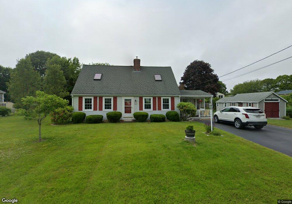
9 Andrews St Buzzards Bay, MA 02532
Estimated Value: $584,505 - $769,000
3
Beds
2
Baths
1,201
Sq Ft
$542/Sq Ft
Est. Value
About This Home
This home is located at 9 Andrews St, Buzzards Bay, MA 02532 and is currently estimated at $651,376, approximately $542 per square foot. 9 Andrews St is a home located in Plymouth County.
Ownership History
Date
Name
Owned For
Owner Type
Purchase Details
Closed on
Jan 29, 2013
Sold by
Johnson David F and Johnson Elaine E
Bought by
T F
Current Estimated Value
Purchase Details
Closed on
Sep 6, 2001
Sold by
Wilkins Kenneth A and Wilkins Mildred E
Bought by
Johnson Elaine E and Johnson David P
Purchase Details
Closed on
Sep 23, 1987
Sold by
Fitzpatrick T F
Bought by
Wilkins Kenneth A
Create a Home Valuation Report for This Property
The Home Valuation Report is an in-depth analysis detailing your home's value as well as a comparison with similar homes in the area
Home Values in the Area
Average Home Value in this Area
Purchase History
| Date | Buyer | Sale Price | Title Company |
|---|---|---|---|
| T F | -- | -- | |
| Ferrara | -- | -- | |
| Johnson Elaine E | $239,900 | -- | |
| Johnson Elaine E | $239,900 | -- | |
| Wilkins Kenneth A | $133,000 | -- |
Source: Public Records
Mortgage History
| Date | Status | Borrower | Loan Amount |
|---|---|---|---|
| Previous Owner | Wilkins Kenneth A | $157,000 | |
| Previous Owner | Wilkins Kenneth A | $172,300 | |
| Previous Owner | Wilkins Kenneth A | $150,000 |
Source: Public Records
Tax History Compared to Growth
Tax History
| Year | Tax Paid | Tax Assessment Tax Assessment Total Assessment is a certain percentage of the fair market value that is determined by local assessors to be the total taxable value of land and additions on the property. | Land | Improvement |
|---|---|---|---|---|
| 2025 | $5,936 | $540,600 | $183,500 | $357,100 |
| 2024 | $5,793 | $496,000 | $131,000 | $365,000 |
| 2023 | $5,087 | $440,300 | $119,000 | $321,300 |
| 2022 | $5,087 | $373,500 | $119,000 | $254,500 |
| 2021 | $5,065 | $361,800 | $119,000 | $242,800 |
| 2020 | $5,125 | $373,800 | $142,800 | $231,000 |
| 2019 | $5,032 | $371,100 | $148,200 | $222,900 |
| 2018 | $4,767 | $339,500 | $148,200 | $191,300 |
| 2017 | $4,606 | $329,500 | $148,200 | $181,300 |
| 2016 | $4,526 | $321,200 | $135,100 | $186,100 |
| 2015 | $4,400 | $321,200 | $135,100 | $186,100 |
| 2014 | $3,616 | $272,100 | $115,800 | $156,300 |
Source: Public Records
Map
Nearby Homes
- 22 Bay View Ave
- 17 Carleton St Unit 17
- 6 Unit 74
- 12 Grove St
- 35 Locust St
- 35 Locust St
- 0 Broad St Off Unit 72362523
- 1 Pine Tree Dr
- 45 Kins Ct
- 46 Kins Ct
- 3 Fairway Dr Unit F
- 38 Amos Way
- 37 Bay Pointe Drive Extension Unit 37
- 13 Bay Pointe Drive Extension Unit 13
- 12 Beacon St Unit 84
- 46 Winship Ave
- 52 Starboard Dr Unit 36H
- 2 Beacon St Unit 77
- 69 Bay Pointe Drive Extension Unit 69
- 26 Highland Ave