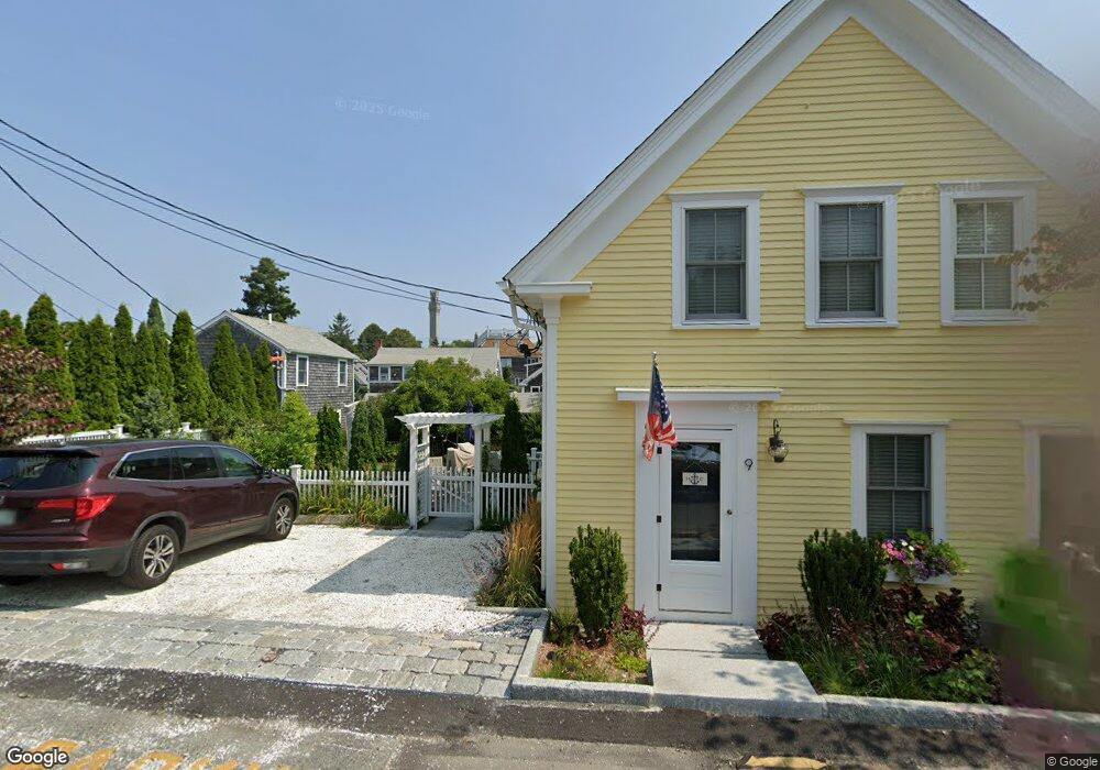
9 Atlantic Ave Provincetown, MA 02657
Estimated Value: $1,989,000 - $3,011,000
4
Beds
3
Baths
1,441
Sq Ft
$1,645/Sq Ft
Est. Value
About This Home
This home is located at 9 Atlantic Ave, Provincetown, MA 02657 and is currently estimated at $2,370,014, approximately $1,644 per square foot. 9 Atlantic Ave is a home located in Barnstable County with nearby schools including Provincetown Schools.
Ownership History
Date
Name
Owned For
Owner Type
Purchase Details
Closed on
Dec 24, 2024
Sold by
Norcross Christine E and Vanderveen Deborah K
Bought by
Christine E Norcross Ft and Vanderveen
Current Estimated Value
Purchase Details
Closed on
Jan 14, 2005
Sold by
Palheiro Edith W
Bought by
Norcross Christine E and Vanderveen Deborah
Home Financials for this Owner
Home Financials are based on the most recent Mortgage that was taken out on this home.
Original Mortgage
$460,400
Interest Rate
5.81%
Mortgage Type
Purchase Money Mortgage
Create a Home Valuation Report for This Property
The Home Valuation Report is an in-depth analysis detailing your home's value as well as a comparison with similar homes in the area
Home Values in the Area
Average Home Value in this Area
Purchase History
| Date | Buyer | Sale Price | Title Company |
|---|---|---|---|
| Christine E Norcross Ft | -- | None Available | |
| Christine E Norcross Ft | -- | None Available | |
| Christine E Norcross Ft | -- | None Available | |
| Norcross Christine E | $706,000 | -- | |
| Norcross Christine E | $706,000 | -- |
Source: Public Records
Mortgage History
| Date | Status | Borrower | Loan Amount |
|---|---|---|---|
| Previous Owner | Norcross Christine E | $460,400 |
Source: Public Records
Tax History Compared to Growth
Tax History
| Year | Tax Paid | Tax Assessment Tax Assessment Total Assessment is a certain percentage of the fair market value that is determined by local assessors to be the total taxable value of land and additions on the property. | Land | Improvement |
|---|---|---|---|---|
| 2025 | $11,603 | $2,072,000 | $857,900 | $1,214,100 |
| 2024 | $10,960 | $1,964,100 | $817,500 | $1,146,600 |
| 2023 | $9,701 | $1,622,200 | $711,000 | $911,200 |
| 2022 | $9,219 | $1,384,300 | $664,500 | $719,800 |
| 2021 | $7,508 | $1,060,400 | $604,100 | $456,300 |
| 2020 | $6,898 | $1,042,000 | $608,300 | $433,700 |
| 2019 | $7,028 | $995,400 | $590,600 | $404,800 |
| 2018 | $6,748 | $905,800 | $584,200 | $321,600 |
| 2017 | $6,198 | $803,900 | $513,500 | $290,400 |
| 2016 | $6,079 | $779,300 | $498,500 | $280,800 |
Source: Public Records
Map
Nearby Homes
- 7 Central St
- 3 Atlantic Ave
- 162 Commercial St
- 165 Commercial St Unit 4
- 176 Commercial St Unit 2
- 3 Carver Ct
- 147 Commercial St Unit L7
- 147 Commercial St Unit UL7
- 134 Commercial St
- 26 Pleasant St Unit 5
- 27 Court St Pf
- 27 Court St Unit PF
- 7 Kings Way
- 36 Shank Painter Rd Unit 11
- 22 Brown St
- 234 Commercial St
- 10 Bradford St Unit 1
- 10A Bradford St Unit 1
- 10 Bradford St Unit 4
- 10 Bradford St Unit 2
- 7 Atlantic Ave
- 7 Atlantic Ave Unit 1 & 2
- 10 Central St
- 8 Central St
- 8 Central St Unit 1-3
- 11 Atlantic Ave Unit C
- 11 Atlantic Ave Unit B
- 11 Atlantic Ave Unit A
- 11 Atlantic Ave
- 11 Atlantic Ave Unit UA
- 8 Atlantic Ave Unit F
- 10 Atlantic Ave Unit F
- 10 Atlantic Ave Unit C
- 10 Atlantic Ave Unit D
- 10 Atlantic Ave
- 8 Atlantic Ave Unit UB
- 8 Atlantic Ave Unit B
- 8 Atlantic Ave Unit G
- 8 Atlantic Ave Unit D
- 8 Atlantic Ave Unit C