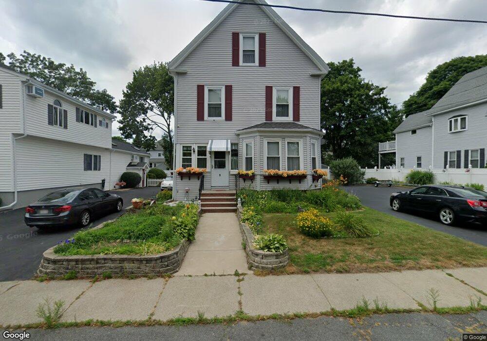
9 Avon St Saugus, MA 01906
Cliftondale NeighborhoodEstimated Value: $716,000 - $846,000
5
Beds
2
Baths
2,351
Sq Ft
$339/Sq Ft
Est. Value
About This Home
This home is located at 9 Avon St, Saugus, MA 01906 and is currently estimated at $796,205, approximately $338 per square foot. 9 Avon St is a home located in Essex County with nearby schools including Saugus High School, Pioneer Charter School Of Science II, and Malden Catholic.
Ownership History
Date
Name
Owned For
Owner Type
Purchase Details
Closed on
Nov 7, 2018
Sold by
Ananian David J and Avola Doreen M
Bought by
Slater T
Current Estimated Value
Purchase Details
Closed on
Jul 7, 2003
Sold by
Avola Doreen M
Bought by
Slater T
Purchase Details
Closed on
Jan 30, 1992
Sold by
Plassmann Ernest and Plassmann Barbara
Bought by
Slater Trust
Create a Home Valuation Report for This Property
The Home Valuation Report is an in-depth analysis detailing your home's value as well as a comparison with similar homes in the area
Home Values in the Area
Average Home Value in this Area
Purchase History
| Date | Buyer | Sale Price | Title Company |
|---|---|---|---|
| Slater T | -- | -- | |
| Slater T | -- | -- | |
| Slater Trust | $135,000 | -- |
Source: Public Records
Mortgage History
| Date | Status | Borrower | Loan Amount |
|---|---|---|---|
| Previous Owner | Slater Trust | $92,500 | |
| Previous Owner | Slater Trust | $77,900 |
Source: Public Records
Tax History Compared to Growth
Tax History
| Year | Tax Paid | Tax Assessment Tax Assessment Total Assessment is a certain percentage of the fair market value that is determined by local assessors to be the total taxable value of land and additions on the property. | Land | Improvement |
|---|---|---|---|---|
| 2025 | $7,097 | $664,500 | $314,100 | $350,400 |
| 2024 | $6,827 | $641,000 | $296,200 | $344,800 |
| 2023 | $6,703 | $595,300 | $260,300 | $335,000 |
| 2022 | $6,364 | $529,900 | $238,700 | $291,200 |
| 2021 | $5,903 | $478,400 | $207,300 | $271,100 |
| 2020 | $5,464 | $458,400 | $197,500 | $260,900 |
| 2019 | $5,364 | $440,400 | $179,500 | $260,900 |
| 2018 | $4,880 | $421,400 | $174,100 | $247,300 |
| 2017 | $4,526 | $375,600 | $162,400 | $213,200 |
| 2016 | $3,991 | $327,100 | $162,200 | $164,900 |
| 2015 | $3,743 | $311,400 | $154,400 | $157,000 |
| 2014 | $3,871 | $333,400 | $154,400 | $179,000 |
Source: Public Records
Map
Nearby Homes
- 32-34 Mount Vernon St
- 28 Eustis St
- 292 Salem St Unit 101
- 32 Staaf Rd
- 2 Ashford St
- 4 Foss Ave
- 47 School St
- 35 Liberty Ave
- 166 Essex St
- 184 Breedens Ln
- 15 Stone St
- 133 Salem St Unit 418
- 133 Salem St Unit 412
- 133 Salem St Unit 213
- 133 Salem St Unit 416
- 133 Salem St Unit 307
- 133 Salem St Unit 417
- 133 Salem St Unit 414
- 133 Salem St Unit 315
- 133 Salem St Unit 102