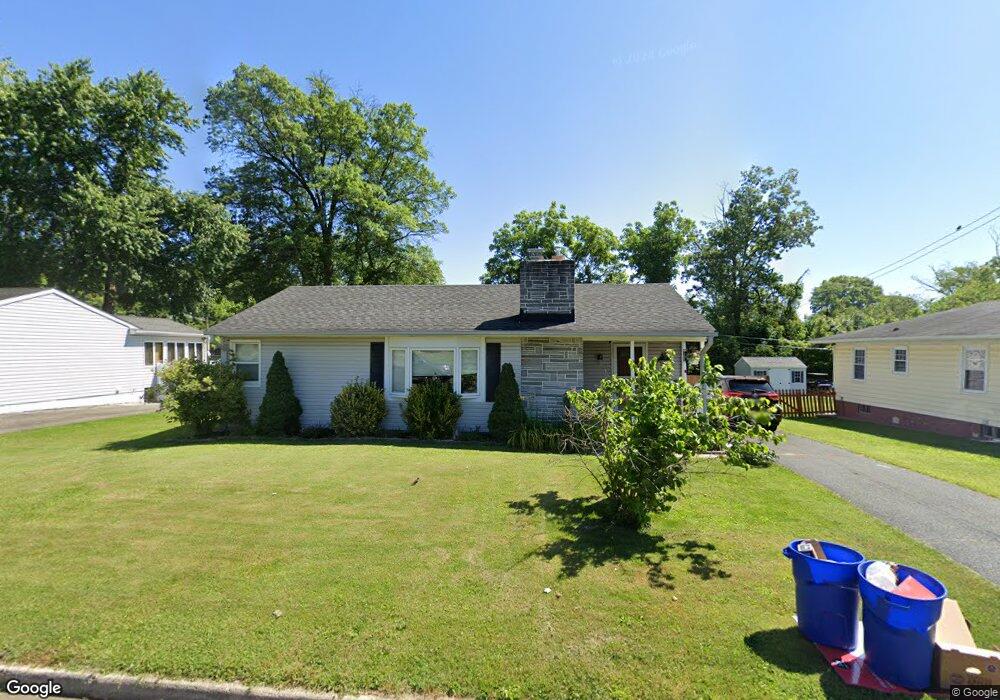
9 Brooks Rd Bel Air, MD 21014
Estimated Value: $355,000 - $436,000
3
Beds
2
Baths
1,407
Sq Ft
$277/Sq Ft
Est. Value
About This Home
This home is located at 9 Brooks Rd, Bel Air, MD 21014 and is currently estimated at $389,738, approximately $276 per square foot. 9 Brooks Rd is a home located in Harford County with nearby schools including Bel Air Elementary School, Bel Air Middle School, and Bel Air High School.
Ownership History
Date
Name
Owned For
Owner Type
Purchase Details
Closed on
Oct 14, 2005
Sold by
Brooks Carl N
Bought by
Brooks Carl N and Brooks Lauren Maria
Current Estimated Value
Home Financials for this Owner
Home Financials are based on the most recent Mortgage that was taken out on this home.
Original Mortgage
$210,400
Outstanding Balance
$112,970
Interest Rate
5.81%
Mortgage Type
New Conventional
Estimated Equity
$276,768
Purchase Details
Closed on
Aug 22, 2001
Sold by
Walter Teresa M
Bought by
Brooks Carl N
Purchase Details
Closed on
Oct 15, 1999
Sold by
Walter Teresa M
Bought by
Walter Teresa M and Guercio Henry P
Purchase Details
Closed on
Dec 3, 1997
Sold by
Bente Henry F
Bought by
Walter Teresa M and Guercio Henry P
Create a Home Valuation Report for This Property
The Home Valuation Report is an in-depth analysis detailing your home's value as well as a comparison with similar homes in the area
Home Values in the Area
Average Home Value in this Area
Purchase History
| Date | Buyer | Sale Price | Title Company |
|---|---|---|---|
| Brooks Carl N | -- | -- | |
| Brooks Carl N | $152,750 | -- | |
| Walter Teresa M | -- | -- | |
| Walter Teresa M | $129,010 | -- |
Source: Public Records
Mortgage History
| Date | Status | Borrower | Loan Amount |
|---|---|---|---|
| Open | Brooks Carl N | $210,400 | |
| Closed | Brooks Carl N | -- |
Source: Public Records
Tax History
| Year | Tax Paid | Tax Assessment Tax Assessment Total Assessment is a certain percentage of the fair market value that is determined by local assessors to be the total taxable value of land and additions on the property. | Land | Improvement |
|---|---|---|---|---|
| 2025 | $2,376 | $288,800 | $78,400 | $210,400 |
| 2024 | $2,376 | $267,167 | $0 | $0 |
| 2023 | $2,253 | $245,533 | $0 | $0 |
| 2022 | $2,134 | $223,900 | $78,400 | $145,500 |
| 2021 | $2,252 | $223,900 | $78,400 | $145,500 |
| 2020 | $2,252 | $223,900 | $78,400 | $145,500 |
| 2019 | $2,383 | $236,900 | $97,700 | $139,200 |
| 2018 | $2,355 | $236,267 | $0 | $0 |
| 2017 | $2,349 | $236,900 | $0 | $0 |
| 2016 | -- | $235,000 | $0 | $0 |
| 2015 | $2,402 | $235,000 | $0 | $0 |
| 2014 | $2,402 | $235,000 | $0 | $0 |
Source: Public Records
Map
Nearby Homes
- 108 Archer St
- 24 N Atwood Rd
- 537 Park Manor Cir
- 101 Nichols St Unit F
- 259 Beckenham Cir Unit 404
- 633 Wallingford Rd Unit 302
- 10 Shannon Dr
- 17 Shannon Dr
- 636 Wallingford Rd Unit 3J
- 637 Wallingford Rd Unit 102
- 204 Chaucer Ln Unit I
- 601 Thames Way Unit E
- 501 Giles St
- 298 Canterbury Rd Unit 298-M
- 200 Thames Way Unit I
- 601 Churchhill Rd Unit 601-E
- 606 Squire Ln Unit G
- 606 Squire Ln Unit 606-A
- 302 Canterbury Rd Unit J
- 302 Canterbury Rd Unit E
Your Personal Tour Guide
Ask me questions while you tour the home.