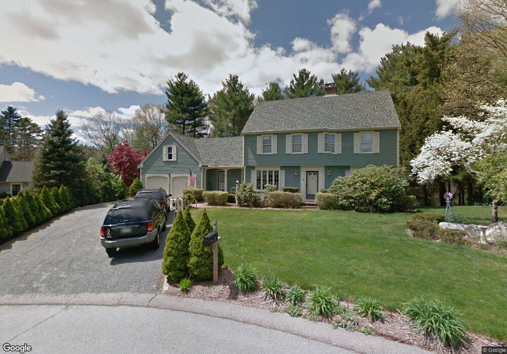
9 Brookview Ln North Easton, MA 02356
Estimated Value: $960,000 - $1,089,000
4
Beds
4
Baths
2,574
Sq Ft
$399/Sq Ft
Est. Value
About This Home
This home is located at 9 Brookview Ln, North Easton, MA 02356 and is currently estimated at $1,028,036, approximately $399 per square foot. 9 Brookview Ln is a home located in Bristol County with nearby schools including Easton Middle School.
Ownership History
Date
Name
Owned For
Owner Type
Purchase Details
Closed on
Dec 27, 2019
Sold by
Vanzandt Richard N and Vanzandt Karen L
Bought by
Vanzandt Ft and Vanzandt
Current Estimated Value
Purchase Details
Closed on
Nov 16, 1995
Sold by
Tokarz Edward M and Tokarz Julia R
Bought by
Vanzandt Richard N and Vanzandt Karen L
Create a Home Valuation Report for This Property
The Home Valuation Report is an in-depth analysis detailing your home's value as well as a comparison with similar homes in the area
Home Values in the Area
Average Home Value in this Area
Purchase History
| Date | Buyer | Sale Price | Title Company |
|---|---|---|---|
| Vanzandt Ft | -- | None Available | |
| Vanzandt Ft | -- | None Available | |
| Vanzandt Richard N | $330,000 | -- | |
| Vanzandt Richard N | $330,000 | -- |
Source: Public Records
Mortgage History
| Date | Status | Borrower | Loan Amount |
|---|---|---|---|
| Previous Owner | Vanzandt Richard N | $262,000 | |
| Previous Owner | Vanzandt Richard N | $265,000 |
Source: Public Records
Tax History Compared to Growth
Tax History
| Year | Tax Paid | Tax Assessment Tax Assessment Total Assessment is a certain percentage of the fair market value that is determined by local assessors to be the total taxable value of land and additions on the property. | Land | Improvement |
|---|---|---|---|---|
| 2025 | $10,463 | $838,400 | $407,400 | $431,000 |
| 2024 | $9,939 | $744,500 | $314,400 | $430,100 |
| 2023 | $9,945 | $681,600 | $306,100 | $375,500 |
| 2022 | $9,733 | $632,400 | $270,900 | $361,500 |
| 2021 | $9,587 | $619,300 | $257,800 | $361,500 |
| 2020 | $9,290 | $604,000 | $253,000 | $351,000 |
| 2019 | $9,432 | $591,000 | $230,900 | $360,100 |
| 2018 | $9,211 | $568,200 | $230,900 | $337,300 |
| 2017 | $8,845 | $545,300 | $230,900 | $314,400 |
| 2016 | $8,582 | $530,100 | $230,900 | $299,200 |
| 2015 | $7,898 | $470,700 | $196,500 | $274,200 |
| 2014 | $7,779 | $467,200 | $196,500 | $270,700 |
Source: Public Records
Map
Nearby Homes
- 15 King Ave
- 12 Holmes St
- Lot 8 Cooper Ln
- 224 Main St
- 8 Hobart Way
- 225 Main St
- 280 Washington St
- 334-336 Main St
- 175 N Main St
- 11 Olde Stable Ln
- 14 Marshall Rd
- 96 Winterberry Ln
- Lot 1 Winterberry Ln
- Lot 2 Winterberry Ln
- LOT 4 Winterberry Ln
- 86 Union St
- 110 Union St
- 56 Williams St
- 95 Union St
- 67 Center St
- 10 Brookview Ln
- 5 Brookview Ln
- 14 Brookview Ln Unit 14
- 1 Brookview Ln
- 6 Brookview Ln
- 2 Brookview Ln
- 46 Whitmans Brook Dr
- 1 Harvestwood Ln
- lot 33 Eastwood Ln
- 2 Harvestwood Ln
- 1 Eastwood Ln
- 2 Eastwood Ln
- 1 Woodledge Ln
- 19 Whitmans Brook Dr
- 5 Woodledge Ln
- 5 Eastwood Ln
- 5 Harvestwood Ln
- 6 Harvestwood Ln
- 2 Woodledge Ln
- 104 Elm St