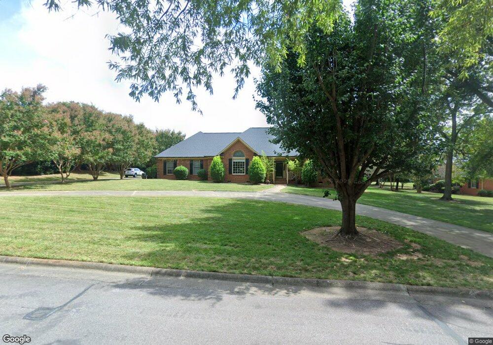
9 Butterwick Place Durham, NC 27705
Croasdaile NeighborhoodEstimated Value: $844,000 - $963,000
4
Beds
4
Baths
3,049
Sq Ft
$302/Sq Ft
Est. Value
About This Home
This home is located at 9 Butterwick Place, Durham, NC 27705 and is currently estimated at $920,852, approximately $302 per square foot. 9 Butterwick Place is a home located in Durham County with nearby schools including Hillandale Elementary School, George L Carrington Middle, and Riverside High School.
Ownership History
Date
Name
Owned For
Owner Type
Purchase Details
Closed on
Mar 20, 2017
Sold by
Fulp Marice M
Bought by
Spruill Thomas R
Current Estimated Value
Home Financials for this Owner
Home Financials are based on the most recent Mortgage that was taken out on this home.
Original Mortgage
$450,000
Outstanding Balance
$367,430
Interest Rate
3.63%
Mortgage Type
New Conventional
Estimated Equity
$553,422
Create a Home Valuation Report for This Property
The Home Valuation Report is an in-depth analysis detailing your home's value as well as a comparison with similar homes in the area
Home Values in the Area
Average Home Value in this Area
Purchase History
| Date | Buyer | Sale Price | Title Company |
|---|---|---|---|
| Spruill Thomas R | $500,000 | -- |
Source: Public Records
Mortgage History
| Date | Status | Borrower | Loan Amount |
|---|---|---|---|
| Open | Spruill Thomas R | $450,000 |
Source: Public Records
Tax History
| Year | Tax Paid | Tax Assessment Tax Assessment Total Assessment is a certain percentage of the fair market value that is determined by local assessors to be the total taxable value of land and additions on the property. | Land | Improvement |
|---|---|---|---|---|
| 2025 | $8,887 | $896,486 | $343,200 | $553,286 |
| 2024 | $8,039 | $576,290 | $268,076 | $308,214 |
| 2023 | $7,549 | $576,290 | $268,076 | $308,214 |
| 2022 | $7,376 | $576,290 | $268,076 | $308,214 |
| 2021 | $7,341 | $576,290 | $268,076 | $308,214 |
| 2020 | $7,168 | $576,290 | $268,076 | $308,214 |
| 2019 | $7,168 | $576,290 | $268,076 | $308,214 |
| 2018 | $6,645 | $489,850 | $114,075 | $375,775 |
| 2017 | $6,596 | $489,850 | $114,075 | $375,775 |
| 2016 | $6,373 | $489,850 | $114,075 | $375,775 |
| 2015 | $7,481 | $540,403 | $145,001 | $395,402 |
| 2014 | $7,481 | $540,403 | $145,001 | $395,402 |
Source: Public Records
Map
Nearby Homes
- 3735 Stoneybrook Dr
- 1513 Cole Mill Rd
- 3716 Medford Rd
- 3737 Medford Rd
- 1217 Opal Ln
- 1221 Opal Ln
- 1229 Opal Ln
- 3710 Dairy Pond Place
- 524 Soapstone Dr
- 1011 Coldspring Cir
- 1007 Coldspring Cir
- 1005 Coldspring Cir
- 1001 Coldspring Cir
- 1003 Coldspring Cir
- 1047 Coldspring Cir
- 2104 Skipping Stone Dr
- 605 Blackwood Ct
- 209 Old Mill Place
- 105 Old Mill Place
- 104 Old Mill Place
- 3631 Stoneybrook Dr
- 15 Butterwick Place
- 3625 Stoneybrook Dr
- 12 Butterwick Place
- 12 Butterwick Place
- 18 Butterwick Place
- 3630 Stoneybrook Dr
- 3704 Stoneybrook Dr
- 3624 Stoneybrook Dr
- 3711 Stoneybrook Dr
- 3609 Stoneybrook Dr
- 3618 Stoneybrook Dr
- 3712 Stoneybrook Dr
- 3612 Stoneybrook Dr
- 3603 Stoneybrook Dr
- 3519 Stoneybrook Dr
- 1410 Cole Mill Rd
- 3606 Stoneybrook Dr
- 3531 Stoneybrook Dr
- 1414 Cole Mill Rd
Your Personal Tour Guide
Ask me questions while you tour the home.