Estimated Value: $541,563 - $606,000
--
Bed
--
Bath
3,055
Sq Ft
$186/Sq Ft
Est. Value
About This Home
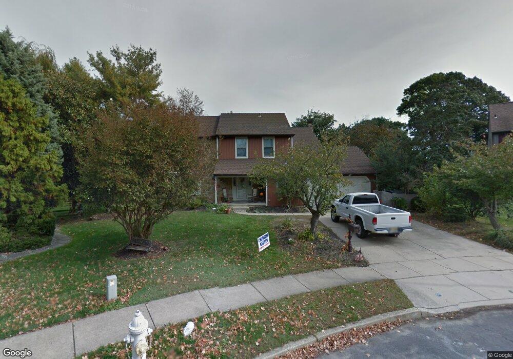
This home is located at 9 Buxton Ct, West Deptford, NJ 08051 and is currently estimated at $567,641, approximately $185 per square foot. 9 Buxton Ct is a home located in Gloucester County with nearby schools including Green-Fields Elementary School, Oakview Elementary School, and Red Bank Elementary School.
Ownership History
Date
Name
Owned For
Owner Type
Purchase Details
Closed on
Jun 29, 2004
Sold by
Kane John J and Kane Lois C
Bought by
Labbree Paul and Labbree Theresa
Current Estimated Value
Home Financials for this Owner
Home Financials are based on the most recent Mortgage that was taken out on this home.
Original Mortgage
$228,000
Outstanding Balance
$114,501
Interest Rate
6.3%
Mortgage Type
Purchase Money Mortgage
Estimated Equity
$453,140
Purchase Details
Closed on
Aug 4, 1997
Sold by
Kane John J and Kane Lois C
Bought by
Kane Lois C
Create a Home Valuation Report for This Property
The Home Valuation Report is an in-depth analysis detailing your home's value as well as a comparison with similar homes in the area
Home Values in the Area
Average Home Value in this Area
Purchase History
| Date | Buyer | Sale Price | Title Company |
|---|---|---|---|
| Labbree Paul | $285,000 | Franklin Title Agency | |
| Kane Lois C | -- | -- |
Source: Public Records
Mortgage History
| Date | Status | Borrower | Loan Amount |
|---|---|---|---|
| Open | Labbree Paul | $228,000 |
Source: Public Records
Tax History Compared to Growth
Tax History
| Year | Tax Paid | Tax Assessment Tax Assessment Total Assessment is a certain percentage of the fair market value that is determined by local assessors to be the total taxable value of land and additions on the property. | Land | Improvement |
|---|---|---|---|---|
| 2025 | $12,173 | $348,600 | $92,900 | $255,700 |
| 2024 | $12,016 | $348,600 | $92,900 | $255,700 |
| 2023 | $12,016 | $348,600 | $92,900 | $255,700 |
| 2022 | $11,960 | $348,600 | $92,900 | $255,700 |
| 2021 | $11,919 | $348,600 | $92,900 | $255,700 |
| 2020 | $11,891 | $348,600 | $92,900 | $255,700 |
| 2019 | $11,560 | $348,600 | $92,900 | $255,700 |
| 2018 | $11,246 | $348,600 | $92,900 | $255,700 |
| 2017 | $10,984 | $348,600 | $92,900 | $255,700 |
| 2016 | $10,678 | $348,600 | $92,900 | $255,700 |
| 2015 | $10,172 | $348,600 | $92,900 | $255,700 |
| 2014 | $9,667 | $348,600 | $92,900 | $255,700 |
Source: Public Records
Map
Nearby Homes
- 463 Durham Ct
- 411 Durham Ct Unit 411
- 827 Saint Regis Ct
- 807 Saint Regis Ct
- 213 Barclay Ct
- 751 Garrison Ct
- 75 Hickory Ave
- 111 Cove Rd
- 629 Vassar Rd
- 125 Ivy Ln
- 7 Manchester Ct
- 90 Ginger Dr
- 748 Dartmouth Dr
- 114 Buddy Powell Ln
- 100 Buddy Powell Ln
- 1121 Tristram Cir Unit 1
- 212 Fawn Meadow Dr
- 1134 Tristram Cir Unit 4
- 15 Ash Ave
- 14 Aviary Rd