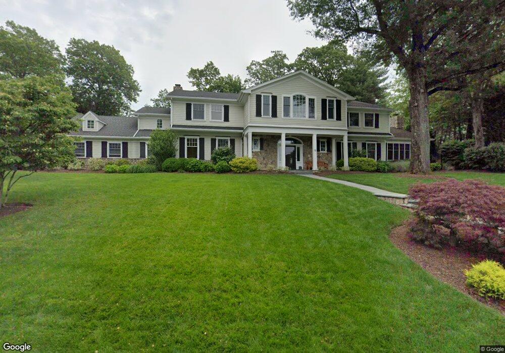
9 Canterbury Ln Summit, NJ 07901
Estimated Value: $3,150,054 - $4,922,000
--
Bed
--
Bath
6,272
Sq Ft
$621/Sq Ft
Est. Value
About This Home
This home is located at 9 Canterbury Ln, Summit, NJ 07901 and is currently estimated at $3,894,351, approximately $620 per square foot. 9 Canterbury Ln is a home located in Union County with nearby schools including L C Johnson Summit Middle School, Summit Sr High School, and Oak Knoll School of the Holy Child.
Ownership History
Date
Name
Owned For
Owner Type
Purchase Details
Closed on
Aug 1, 2006
Sold by
Brody Richard
Bought by
Stone Bradford S and Stone Pamela E
Current Estimated Value
Home Financials for this Owner
Home Financials are based on the most recent Mortgage that was taken out on this home.
Original Mortgage
$1,200,000
Interest Rate
6.46%
Mortgage Type
New Conventional
Purchase Details
Closed on
Jul 29, 2005
Sold by
Peer Diane
Bought by
Peer Peer V and Peer Diane
Purchase Details
Closed on
Apr 23, 2004
Sold by
Kroll Robert
Bought by
Brody Richard and Brody Lauren Reiter
Home Financials for this Owner
Home Financials are based on the most recent Mortgage that was taken out on this home.
Original Mortgage
$440,000
Interest Rate
6.12%
Create a Home Valuation Report for This Property
The Home Valuation Report is an in-depth analysis detailing your home's value as well as a comparison with similar homes in the area
Home Values in the Area
Average Home Value in this Area
Purchase History
| Date | Buyer | Sale Price | Title Company |
|---|---|---|---|
| Stone Bradford S | $3,275,000 | -- | |
| Peer Peer V | -- | -- | |
| Brody Richard | $1,800,000 | -- |
Source: Public Records
Mortgage History
| Date | Status | Borrower | Loan Amount |
|---|---|---|---|
| Closed | Stone Bradford S | $1,200,000 | |
| Previous Owner | Brody Richard | $440,000 |
Source: Public Records
Tax History Compared to Growth
Tax History
| Year | Tax Paid | Tax Assessment Tax Assessment Total Assessment is a certain percentage of the fair market value that is determined by local assessors to be the total taxable value of land and additions on the property. | Land | Improvement |
|---|---|---|---|---|
| 2025 | $57,717 | $1,325,000 | $457,400 | $867,600 |
| 2024 | $57,333 | $1,325,000 | $457,400 | $867,600 |
| 2023 | $57,333 | $1,325,000 | $457,400 | $867,600 |
| 2022 | $56,750 | $1,325,000 | $457,400 | $867,600 |
| 2021 | $57,200 | $1,325,000 | $457,400 | $867,600 |
| 2020 | $57,770 | $1,325,000 | $457,400 | $867,600 |
| 2019 | $57,836 | $1,325,000 | $457,400 | $867,600 |
| 2018 | $57,465 | $1,325,000 | $457,400 | $867,600 |
| 2017 | $57,836 | $1,325,000 | $457,400 | $867,600 |
| 2016 | $56,988 | $1,325,000 | $457,400 | $867,600 |
| 2015 | $55,875 | $1,325,000 | $457,400 | $867,600 |
| 2014 | $54,431 | $1,325,000 | $457,400 | $867,600 |
Source: Public Records
Map
Nearby Homes
- 110 Division Ave
- 4 Midland Terrace
- 47 Parkview Terrace
- 25 Division Ave
- 171 Grant Ave
- 29 Druid Hill Rd
- 709 Springfield Ave Unit 4
- 709 Springfield Ave Unit 3
- 54 Badgley Dr
- 97 the Fellsway
- 100 Larned Rd
- 140 Countryside Dr
- 24 Primrose Dr
- 67 Laurel Dr
- 62 Beekman Rd
- 183 Countryside Dr
- 34 Grant Ave
- 19 Hickson Dr
- 67 Tulip St
- 52 Greenwood Rd