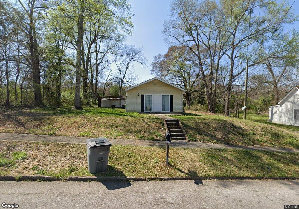
9 Cary St Lagrange, GA 30241
Estimated Value: $126,000 - $140,000
2
Beds
1
Bath
1,122
Sq Ft
$117/Sq Ft
Est. Value
About This Home
This home is located at 9 Cary St, Lagrange, GA 30241 and is currently estimated at $130,893, approximately $116 per square foot. 9 Cary St is a home located in Troup County with nearby schools including Franklin Forest Elementary School, Hollis Hand Elementary School, and Ethel W. Kight Elementary School.
Ownership History
Date
Name
Owned For
Owner Type
Purchase Details
Closed on
Jan 31, 2022
Sold by
Ahmad Hawar
Bought by
Saeed Karzan Azad
Current Estimated Value
Purchase Details
Closed on
Jul 21, 2017
Sold by
Bond Talton M
Bought by
Hawar Ahmad
Purchase Details
Closed on
Jun 10, 1994
Sold by
Lafayette Mini Storage
Bought by
Bond Talton M
Purchase Details
Closed on
Dec 22, 1993
Sold by
Anderson Joey
Bought by
Lafayette Mini Storage
Purchase Details
Closed on
Feb 8, 1985
Sold by
Howell Arrington
Bought by
Anderson Joey
Purchase Details
Closed on
Feb 1, 1985
Sold by
Linda A Bevel
Bought by
Howell Arrington
Purchase Details
Closed on
Apr 15, 1981
Sold by
J A and J Hester T
Bought by
Linda A Bevel
Purchase Details
Closed on
Nov 1, 1966
Sold by
Farmer
Bought by
J A and J Hester T
Create a Home Valuation Report for This Property
The Home Valuation Report is an in-depth analysis detailing your home's value as well as a comparison with similar homes in the area
Purchase History
| Date | Buyer | Sale Price | Title Company |
|---|---|---|---|
| Saeed Karzan Azad | $65,500 | -- | |
| Hawar Ahmad | $30,000 | -- | |
| Bond Talton M | $39,500 | -- | |
| Lafayette Mini Storage | $3,800 | -- | |
| Anderson Joey | -- | -- | |
| Howell Arrington | $16,000 | -- | |
| Linda A Bevel | $14,000 | -- | |
| J A | -- | -- |
Source: Public Records
Tax History
| Year | Tax Paid | Tax Assessment Tax Assessment Total Assessment is a certain percentage of the fair market value that is determined by local assessors to be the total taxable value of land and additions on the property. | Land | Improvement |
|---|---|---|---|---|
| 2025 | $1,157 | $37,544 | $5,480 | $32,064 |
| 2024 | $1,157 | $42,420 | $5,480 | $36,940 |
| 2023 | $715 | $26,588 | $5,480 | $21,108 |
| 2022 | $720 | $25,788 | $5,480 | $20,308 |
| 2021 | $681 | $22,576 | $3,080 | $19,496 |
| 2020 | $681 | $22,576 | $3,080 | $19,496 |
| 2019 | $593 | $19,656 | $3,080 | $16,576 |
| 2018 | $362 | $19,656 | $3,080 | $16,576 |
| 2017 | $621 | $20,584 | $3,128 | $17,456 |
| 2016 | $623 | $20,646 | $3,128 | $17,518 |
| 2015 | $624 | $20,646 | $3,128 | $17,518 |
| 2014 | $597 | $19,724 | $3,128 | $16,596 |
| 2013 | -- | $21,257 | $3,128 | $18,129 |
Source: Public Records
Map
Nearby Homes
- 4 1/2 Barnard Ave
- 5 Curran Ave
- 15 Fulton St
- 204 Cleveland Dr
- 3 Gulfstream Dr
- 212 Cleveland Dr
- 5 Gulfstream Dr
- 130 Clara Jean Ct
- 2 Louise St
- 0 N Barnard Ave
- Coleman Plan at Crossvine Village
- Beckman Plan at Crossvine Village
- Fairfield Plan at Crossvine Village
- Broadmoor Plan at Crossvine Village
- Dover Plan at Crossvine Village
- 87 Youngs Mill Rd
- 115 Clara Jean Ct
- 107 N Barnard Ave
- 110 Lenox Cir
- 304 Bridgette Blvd
Your Personal Tour Guide
Ask me questions while you tour the home.