
Seller's Agent in 2026
Geb Masterson
William Pitt
(714) 473-8530
23 in this area
35 Total Sales
Estimated Value: $629,408 - $659,000
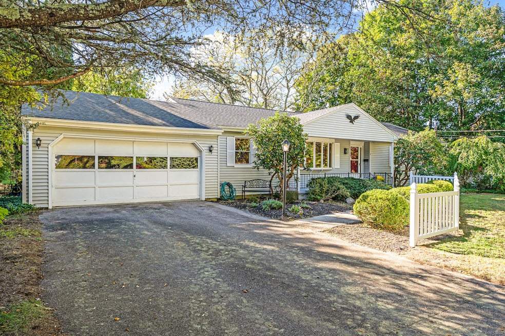
Welcome to 9 Cedar Crest Drive - a classic ranch-style home set on a quiet street in one of Westerly's most convenient neighborhoods. With 1,864 sq ft on the main level plus 1,612 sq ft of partially finished, heated lower-level space, this well-built 3 BR, 2 BA home offers easy single-level living and a relaxed coastal lifestyle. A bright kitchen opens to comfortable living areas, including a cozy den with a wood-burning fireplace and a cheerful sunroom that invites morning coffee or afternoon reading. The private backyard, framed by mature landscaping, provides a tranquil setting for outdoor gatherings. Enjoy the peace of mind of town water and sewer - no wells or septic systems to worry about - along with an 8-year-young roof, attached 2-car garage, and ample guest parking. Just a short stroll from the Pawcatuck River and Westerly Yacht Club, and minutes to Westerly's beautiful beaches and the charming Village of Watch Hill, this home is perfectly positioned for year-round living or a weekend retreat. Solidly built and lovingly maintained, it's ready for your personal touch - a wonderful opportunity to update at your own pace and create the perfect coastal getaway. Westerly's Amtrak station and nearby I-95 make travel from NYC, Fairfield County, and Boston a breeze. Discover the simple joy of life by the sea at 9 Cedar Crest Drive.
Last Agent to Sell the Property
William Pitt Sotheby's Int'l Brokerage Phone: (714) 473-8530 License #RES.0803268 Listed on: 10/19/2025
| Date | Buyer | Sale Price | Title Company |
|---|---|---|---|
| Texeira Richard | $638,000 | -- | |
| Murphy Palmer W | $340,000 | -- |
| Date | Status | Borrower | Loan Amount |
|---|---|---|---|
| Previous Owner | Murphy Palmer W | $25,000 | |
| Previous Owner | Murphy Palmer W | $100,000 |
| Date | Event | Price | List to Sale | Price per Sq Ft |
|---|---|---|---|---|
| 01/07/2026 01/07/26 | Pending | -- | -- | -- |
| 01/05/2026 01/05/26 | Sold | $638,000 | -1.1% | $184 / Sq Ft |
| 10/25/2025 10/25/25 | For Sale | $645,000 | -- | $186 / Sq Ft |
| Year | Tax Paid | Tax Assessment Tax Assessment Total Assessment is a certain percentage of the fair market value that is determined by local assessors to be the total taxable value of land and additions on the property. | Land | Improvement |
|---|---|---|---|---|
| 2025 | $4,022 | $517,000 | $217,800 | $299,200 |
| 2024 | $4,254 | $407,100 | $155,600 | $251,500 |
| 2023 | $4,136 | $407,100 | $155,600 | $251,500 |
| 2022 | $4,112 | $407,100 | $155,600 | $251,500 |
| 2021 | $3,971 | $329,300 | $135,200 | $194,100 |
| 2020 | $3,902 | $329,300 | $135,200 | $194,100 |
| 2019 | $3,866 | $329,300 | $135,200 | $194,100 |
| 2018 | $3,395 | $274,900 | $124,800 | $150,100 |
| 2017 | $3,299 | $274,900 | $124,800 | $150,100 |
| 2016 | $3,299 | $274,900 | $124,800 | $150,100 |
| 2015 | $3,316 | $295,300 | $138,100 | $157,200 |
| 2014 | $3,263 | $295,300 | $138,100 | $157,200 |
Seller's Agent in 2026
Geb Masterson
William Pitt
(714) 473-8530
23 in this area
35 Total Sales
Buyer's Agent in 2026
Samantha Conde
RE/MAX
(401) 714-5784
2 in this area
84 Total Sales
Source: SmartMLS
MLS Number: 24134456
APN: WEST-000117-000133
Disclaimer: Certain information contained herein is derived from information provided by parties other than Homes.com. All information provided is deemed reliable, but is not guaranteed to be accurate and should be independently verified.
![]() IDX information is provided exclusively for personal, non-commercial use, and may not be used for any purpose other than to identify prospective properties consumers may be interested in purchasing. Information is deemed reliable but not guaranteed.
IDX information is provided exclusively for personal, non-commercial use, and may not be used for any purpose other than to identify prospective properties consumers may be interested in purchasing. Information is deemed reliable but not guaranteed.
Ask me questions while you tour the home.