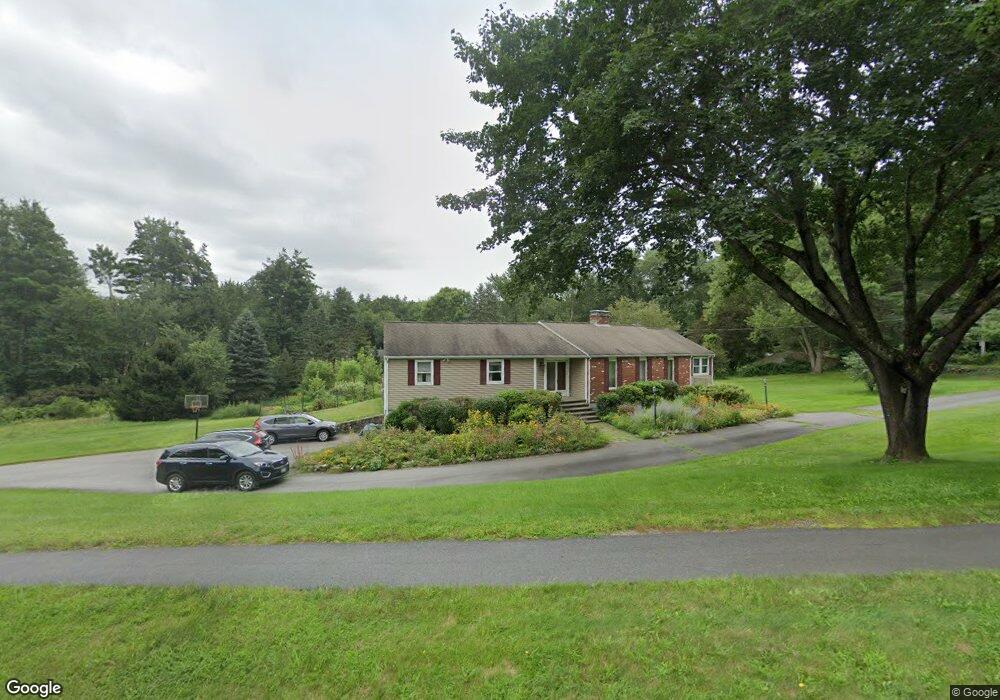
9 Cobleigh Rd Boxborough, MA 01719
Estimated Value: $822,000 - $1,007,000
4
Beds
2
Baths
1,784
Sq Ft
$499/Sq Ft
Est. Value
About This Home
This home is located at 9 Cobleigh Rd, Boxborough, MA 01719 and is currently estimated at $890,091, approximately $498 per square foot. 9 Cobleigh Rd is a home located in Middlesex County with nearby schools including Acton-Boxborough Regional High School.
Ownership History
Date
Name
Owned For
Owner Type
Purchase Details
Closed on
Jul 18, 2019
Sold by
Mcgrory William C
Bought by
Yendluri Esther
Current Estimated Value
Purchase Details
Closed on
Sep 14, 2000
Sold by
Moriarty Catherine and Moriarty Robert
Bought by
Mcgrory William C and Mcgrory Beverly A
Create a Home Valuation Report for This Property
The Home Valuation Report is an in-depth analysis detailing your home's value as well as a comparison with similar homes in the area
Home Values in the Area
Average Home Value in this Area
Purchase History
| Date | Buyer | Sale Price | Title Company |
|---|---|---|---|
| Yendluri Esther | -- | None Available | |
| Yendluri Esther | -- | None Available | |
| Yendluri Esther | -- | None Available | |
| Mcgrory William C | $340,975 | -- |
Source: Public Records
Mortgage History
| Date | Status | Borrower | Loan Amount |
|---|---|---|---|
| Previous Owner | Mcgrory William C | $250,000 | |
| Previous Owner | Mcgrory William C | $219,000 |
Source: Public Records
Tax History Compared to Growth
Tax History
| Year | Tax Paid | Tax Assessment Tax Assessment Total Assessment is a certain percentage of the fair market value that is determined by local assessors to be the total taxable value of land and additions on the property. | Land | Improvement |
|---|---|---|---|---|
| 2025 | $11,353 | $749,900 | $293,900 | $456,000 |
| 2024 | $11,069 | $738,400 | $282,500 | $455,900 |
| 2023 | $10,678 | $688,000 | $243,700 | $444,300 |
| 2022 | $10,375 | $595,600 | $243,700 | $351,900 |
| 2020 | $8,552 | $511,500 | $243,700 | $267,800 |
| 2019 | $8,399 | $511,500 | $243,700 | $267,800 |
| 2018 | $4,322 | $497,600 | $232,300 | $265,300 |
| 2017 | $7,692 | $457,600 | $232,300 | $225,300 |
| 2016 | $7,506 | $458,800 | $232,300 | $226,500 |
| 2015 | $6,790 | $407,800 | $203,800 | $204,000 |
| 2014 | $6,650 | $375,900 | $199,800 | $176,100 |
Source: Public Records
Map
Nearby Homes
- 777 Depot Rd
- 139 Picnic St
- 96 Cedarwood Rd
- 1155 Burroughs Rd
- 134 Russet Ln
- 68 Macintosh Ln
- 89 School House Ln
- 62 Waite Rd
- 30 Paul Revere Rd
- 58 Spencer Rd Unit 18K
- 50 Spencer Rd Unit 36
- 53 Swanson Ct Unit 36C
- 42 Swanson Ct Unit 14A
- 63 Leonard Rd Unit 63
- 220 Swanson Rd Unit 605
- 220 Swanson Rd Unit 606
- 176 Swanson Rd Unit 309
- 12 Olde Lantern Rd
- 5 Elm St Unit 1
- 9 Elm St Unit 1