
Seller's Agent in 2025
Tanya McDermott
Berkshire Hathaway Home Services
(860) 933-0996
7 in this area
72 Total Sales
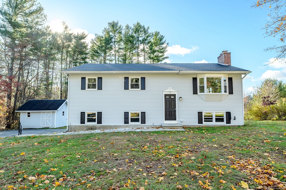
Beautifully renovated 3-bedroom home showcasing a stunning new kitchen with quartz countertops, modern appliances, and sleek finishes. The interior boasts new flooring throughout, updated windows, new roof, and fresh paint inside and out. A partially finished basement adds additional space with a half bath and laundry hookup. Outside, enjoy a brand-new deck, a 2-car attached garage, and a convenient storage shed. Ideally located in a sought-after neighborhood with quick access to Route 6, I-395, and the Rhode Island line.
Last Agent to Sell the Property
Berkshire Hathaway NE Prop. Brokerage Phone: (860) 933-0996 License #RES.0809404 Listed on: 09/01/2025
| Date | Type | Sale Price | Title Company |
|---|---|---|---|
| Commissioners Deed | $109,101 | None Available | |
| Commissioners Deed | $109,101 | None Available | |
| Commissioners Deed | $109,101 | None Available | |
| Warranty Deed | $215,000 | -- | |
| Warranty Deed | $215,000 | -- |
| Date | Status | Loan Amount | Loan Type |
|---|---|---|---|
| Open | $225,000 | Purchase Money Mortgage | |
| Closed | $225,000 | Purchase Money Mortgage | |
| Previous Owner | $172,000 | No Value Available | |
| Previous Owner | $43,000 | No Value Available |
| Date | Event | Price | List to Sale | Price per Sq Ft |
|---|---|---|---|---|
| 12/02/2025 12/02/25 | Sold | $396,000 | +1.8% | $346 / Sq Ft |
| 11/30/2025 11/30/25 | Pending | -- | -- | -- |
| 09/03/2025 09/03/25 | For Sale | $389,000 | -- | $340 / Sq Ft |
| Year | Tax Paid | Tax Assessment Tax Assessment Total Assessment is a certain percentage of the fair market value that is determined by local assessors to be the total taxable value of land and additions on the property. | Land | Improvement |
|---|---|---|---|---|
| 2025 | $4,068 | $175,040 | $37,580 | $137,460 |
| 2024 | $3,870 | $175,040 | $37,580 | $137,460 |
| 2023 | $3,642 | $125,300 | $30,870 | $94,430 |
| 2022 | $3,424 | $125,300 | $30,870 | $94,430 |
| 2021 | $3,413 | $125,300 | $30,870 | $94,430 |
| 2020 | $3,351 | $125,300 | $30,870 | $94,430 |
| 2019 | $3,403 | $125,300 | $30,870 | $94,430 |
| 2017 | $2,874 | $100,100 | $23,870 | $76,230 |
| 2016 | $2,874 | $100,100 | $23,870 | $76,230 |
| 2015 | $2,874 | $100,100 | $23,870 | $76,230 |
| 2014 | $2,794 | $100,100 | $23,870 | $76,230 |
Seller's Agent in 2025
Tanya McDermott
Berkshire Hathaway Home Services
(860) 933-0996
7 in this area
72 Total Sales
Buyer's Agent in 2025
Michele Geragotelis
RE/MAX
(860) 917-6090
7 in this area
163 Total Sales
Source: SmartMLS
MLS Number: 24121143
APN: KILL-000213-000000-000022
Disclaimer: Certain information contained herein is derived from information provided by parties other than Homes.com. All information provided is deemed reliable, but is not guaranteed to be accurate and should be independently verified.
![]() IDX information is provided exclusively for personal, non-commercial use, and may not be used for any purpose other than to identify prospective properties consumers may be interested in purchasing. Information is deemed reliable but not guaranteed.
IDX information is provided exclusively for personal, non-commercial use, and may not be used for any purpose other than to identify prospective properties consumers may be interested in purchasing. Information is deemed reliable but not guaranteed.