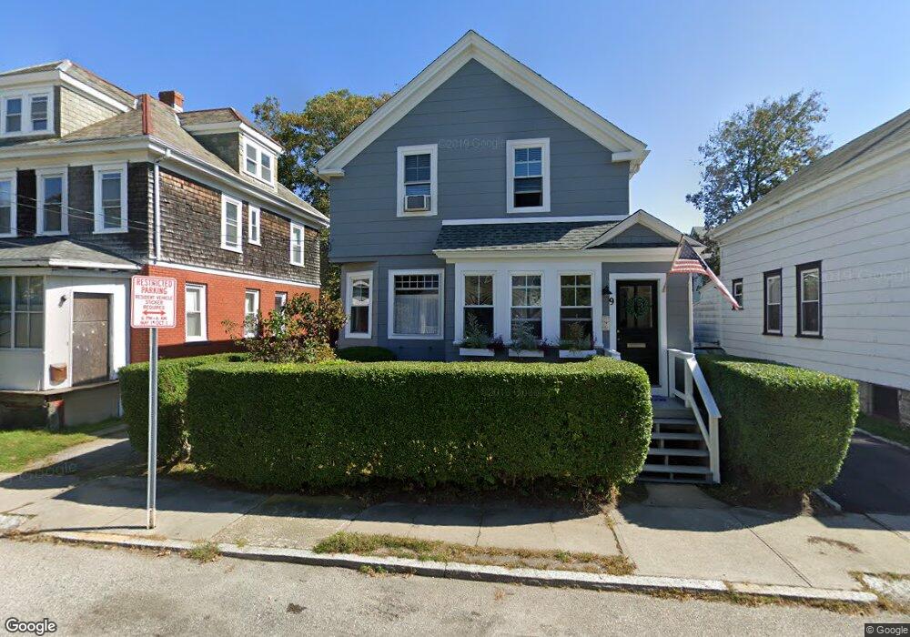
9 Congdon Ave Newport, RI 02840
Estimated Value: $711,000 - $788,000
3
Beds
1
Bath
1,425
Sq Ft
$533/Sq Ft
Est. Value
About This Home
This home is located at 9 Congdon Ave, Newport, RI 02840 and is currently estimated at $759,144, approximately $532 per square foot. 9 Congdon Ave is a home located in Newport County with nearby schools including Rogers High School, St Michael's Country Day School, and St George's School.
Ownership History
Date
Name
Owned For
Owner Type
Purchase Details
Closed on
May 21, 2010
Sold by
Benson Abby Sophia
Bought by
Park Julie
Current Estimated Value
Home Financials for this Owner
Home Financials are based on the most recent Mortgage that was taken out on this home.
Original Mortgage
$251,611
Interest Rate
5.23%
Mortgage Type
Purchase Money Mortgage
Purchase Details
Closed on
Oct 23, 2000
Sold by
Egan Lawrence P
Bought by
Wilcox Benjamin H and Wilcox Abby
Purchase Details
Closed on
Jul 20, 1999
Sold by
Redden Stephen and Dana Richard
Bought by
Egan Lawrence P
Create a Home Valuation Report for This Property
The Home Valuation Report is an in-depth analysis detailing your home's value as well as a comparison with similar homes in the area
Home Values in the Area
Average Home Value in this Area
Purchase History
| Date | Buyer | Sale Price | Title Company |
|---|---|---|---|
| Park Julie | $255,000 | -- | |
| Wilcox Benjamin H | $140,000 | -- | |
| Egan Lawrence P | $111,000 | -- |
Source: Public Records
Mortgage History
| Date | Status | Borrower | Loan Amount |
|---|---|---|---|
| Open | Egan Lawrence P | $235,246 | |
| Closed | Egan Lawrence P | $251,611 | |
| Previous Owner | Egan Lawrence P | $139,000 |
Source: Public Records
Tax History Compared to Growth
Tax History
| Year | Tax Paid | Tax Assessment Tax Assessment Total Assessment is a certain percentage of the fair market value that is determined by local assessors to be the total taxable value of land and additions on the property. | Land | Improvement |
|---|---|---|---|---|
| 2025 | $4,238 | $590,300 | $173,000 | $417,300 |
| 2024 | $4,114 | $590,300 | $173,000 | $417,300 |
| 2023 | $3,870 | $390,100 | $112,200 | $277,900 |
| 2022 | $3,749 | $390,100 | $112,200 | $277,900 |
| 2021 | $3,640 | $390,100 | $112,200 | $277,900 |
| 2020 | $2,829 | $275,200 | $96,900 | $178,300 |
| 2019 | $2,751 | $267,600 | $96,900 | $170,700 |
| 2018 | $2,673 | $267,600 | $96,900 | $170,700 |
| 2017 | $2,606 | $232,500 | $74,500 | $158,000 |
| 2016 | $2,541 | $232,500 | $74,500 | $158,000 |
| 2015 | $2,481 | $232,500 | $74,500 | $158,000 |
| 2014 | $2,694 | $223,400 | $66,600 | $156,800 |
Source: Public Records
Map
Nearby Homes
- 3 Vicksburg Place
- 53 Warner St
- 44 Warner St
- 4 Newport Ave Unit B2
- 5 Bowser Ct
- 7 Sheffield Ave
- 155 Evarts St
- 26 Prescott Hall Rd
- 17 Warner St
- 1 Arnold Ave
- 17 Lincoln St
- 6 Sunshine Ct
- 74 Third St
- 102 Broadway Unit 2B
- 12 Poplar St
- 104 Second St
- 27 Soar Way
- 31 Coddington St Unit 24
- 11 Willow St Unit 5
- 44 Third St